Huron River of Data
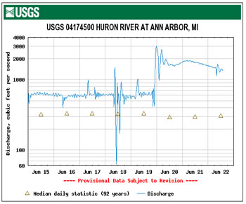
Graph of Huron River water levels on June 18, 2009 when the dam gates were opened. Late on June 19, it started raining hard. (Image links to higher resolution graph. )
Back in mid-June, Paul Christensen, who’s president of the Huron River Fly Fishing Club, gave us a heads up that some fishermen plying their craft in the waters downstream from Argo Dam – himself included – had been surprised the previous morning by a rapid rise then fall of the water levels.
Real time data on river levels and flow rates is available online from the U.S. Geological Survey website, along with archived data and a charting tool. That allowed us to get a visual snapshot of the event as measured by the gauge.
We later headed off to the dam to get a closeup view of the dam’s gates – the incident had been caused by an opening and closing of those gates. But before photographing the gates, we swung by the NEW Center, where the Huron River Watershed Council offices are located, just upstream from the dam. There we touched base with Laura Rubin, executive director of HRWC, to see what she knew about the event.
In the course of that conversation, Rubin suggested that when we went down to take our photos, we look for a new yellow buoy among the familiar line of orange buoys just in front of the dam. More on what the yellow buoy is for, plus an explanation of the gate opening-and-closing event, after the break. We’ll also give an update on where things stand with the future of Argo Dam.
Opening the Gates of Argo: Logs
Point man for mechanical operations and maintenance of Argo and the other dams along the Huron within the city limits is Sumedh Bahl, the unit manager for the city’s water treatment plant. The Chronicle’s phone conversation with Bahl essentially confirmed what the Huron River fishermen had sussed out via inquiries made by the Huron River Watershed Council: A log wedged in the Argo Dam gate had led to a manual opening of the gate, which had caused the rapid rise in water levels.
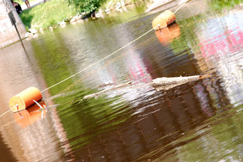
A log floating in water just inside the buoy line at Argo Dam. The pair of legs in the upper left corner belong to a trestle-jumper – something we missed seeing first-hand, but were apprised of by a fisherman who'd seen the (illegal, ill-advised and not condoned by The Chronicle) activity. (Photo by the writer.)
Bahl stressed that it’s not the case that every time a log shows up near the dam that the gates are opened to flush it through. When a log gets trapped near the orange buoy line, said Bahl, they’d typically send out people in a boat to retrieve it.
But in the case of the June 18 gate opening, the log in question was wedged in the partly opened gate, so that the gate could not have closed if it needed to. It’s the computer-controlled, automatic fine tuning of the openings of the gates that keeps the Argo Pond water levels behind the dam almost perfectly constant.
And because it was actually wedged right in the gate, Bahl explained, a decision was made to open the gate and flush the log through, instead of putting people at risk by sending them to retrieve the log in a boat. It was thought that opening the gate just a little would flush the log through, but the “weird shape” of that particular log required a wider opening.
Once the log was flushed through, the dam gates were closed, but not so as to completely block flow. In its minimum flow configuration, the dam will still allow a minimum of 100 cubic feet per second (cfs) through, provided there is adequate “head” to support that flow rate, Bahl said.
The graph on the gauge shows around 67 cfs at its lowest flow rate on June 18, which Bahl clarified was due to the relatively low “head” behind the dam at that particular time.
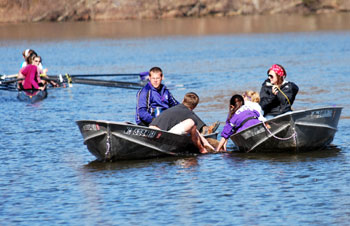
Earlier in the spring of 2009, two motor launches from the Pioneer rowing team hauled a log out of the water. (Photo by the writer.)
When we visited the dam, we observed a log floating just inside the orange buoy line, so based on Bahl’s description it was likely a good candidate to be fished out of the water by boat.
And based on our observation last week, plus an afternoon earlier in the spring spent on the rowing boat dock near Bandemer Park, logs in the river aren’t a rarity.
Logs pose a hazard not just for dam gates, but also for the hulls of the craft that are rowed up and down Argo in training for competition. So when a log is spotted, a motor launch will shepherd it to shore. Back in the spring, we witnessed a log that was massive enough to require two motor launches working together to steer it shoreward.
While the dam’s gates don’t get raised and lowered unless there’s a pressing need, Bahl indicated there’s also not a checklist or a specific protocol for raising and lowering the gates when flushing through a log. If the dam operator anticipated a sustained large volume of water being sent downstream, he said, there would be communication and coordination with the canoe liveries at Argo and Gallup (downstream).
Opening the Gates: Flood Control?
In our conversation with Laura Rubin before heading to the dam to take some photos, she pointed out that while the Argo Dam gates could be raised or lowered to clear logs on occasion, they could not be opened in order to lower the level of Argo Pond. Why not? After all, it might make sense to lower the pond level if a particularly heavy rain is forecast.
Rubin explained that Argo Pond levels are subject to the Lake Level Control Act, so it’s not an option to lower the pond level without a petition. That’s why Argo Pond levels stay within a fraction of an inch of their prescribed levels through automatic adjustment of the dam gates.
The Fishermen
Our trip to Argo Dam was prompted by reports from fishermen downstream of the dam, but when we visited we found a lone fisherman with a line in the water above the dam. Jim Singleton was using shrimp as bait, angling for catfish. His dinner didn’t depend on what he caught, he said. Even if he had some luck, he’d be giving away the fish he caught.

Jim Singleton, who's lived in Ann Arbor most of his life, fishing at Argo Pond. (Photo by the writer.)
Heading downstream from the dam, we didn’t encounter any fishermen between Argo and Island Park, unless the two Mormons on their service mission at Island Park count – as fishers of men’s souls.
It had rained quite heavily and river levels were considerably higher than the morning of June 18 before the dam gates had opened, so it wasn’t surprising we didn’t see anyone wading the river.
In a follow-up phone conversation, Christensen put some numbers on wading the river – which explained the lack of fishermen on our short tour. The flow rate generally needed to be below 1,000 cfs before he’d consider wading the river to fish. And for inexperienced waders and anglers, a rate of somewhere around 600-800 cfs was preferable, he said.
The day of June 18, Christensen been fishing the Riverside Park section of the river, and had caught 3-4 carp before he’d had to scramble out of the water.
For photographers interesting in getting shots of fishermen on the Huron, Christensen suggested sometime in August, when the mayflies hatch. That would bring people from as far as an hour away to fish, he said, joining the 8-10 regulars he knew of who fished the Huron through the summer. Small mouth bass are particularly fond of mayflies.
Another one of the downstream fishermen, who discussed their experiences with the June 18 rapid water rise on the Huron River Net Discussion Board, might be familiar to Chronicle readers in a different guise. On that discussion board, Wally Heralla, describes how he was focused on making long casts for bluegill in a deep pool behind the soccer fields on Fuller Road as the water rose on June 18.
He’d gotten a good dunk, but hadn’t had to swim.
The Yellow Buoys: Temperature Measurement
The yellow buoy at Argo Dam that Laura Rubin had mentioned wasn’t hard to spot. At Rubin’s suggestion, we phoned up Matt Naud, environmental coordinator for the city of Ann Arbor, to ask him about it. The short story is: It’s a thermometer.
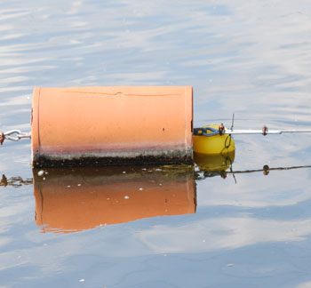
Big orange buoy floating next to small yellow buoy on Argo Pond in Ann Arbor. (Photo by the writer.)
Whether the Argo Pond impoundment has an impact on water temperatures has been a point of contention in the long community conversation that has evolved over the last few years and which intensified over the course of this spring. The new yellow buoy is not an attempt to systematically study temperatures at Argo, but it does reflect a possible collaboration between the city of Ann Arbor and Michigan Technological University.
Naud pointed us toward Tyler Erickson, a research scientist at MTU, who explained by phone that the thermometer was recording temperatures every 15 minutes. They planned to leave it in place for a week to 10 days. Someone will need to physically retrieve the device and then read the memory – as opposed to having a live data transmission in real time to a remote monitoring post.
But Erickson said that MTU does deploy remote sensor packages that have that capability – just not at Argo Dam on the yellow buoy. For the Alaska North Slope, Erickson said, they used devices that had a satellite connection, which allowed remote monitoring, plus the ability to locate the device through GPS coordinates sent from the sensor package.
The Future of Argo Dam
Given the general feeling expressed during the city council work session held on Monday, June 15, there won’t be a definitive dam-in or dam-out decision made by council at its July 6 meeting, even though the city faces a deadline of July 31, 2009 from the state Department of Environmental Quality for a plan to address the toe drains – structures in the part of the dam that consists of a long earthen embankment on its western side. As early as 2004, the DEQ had indicated to the city of Ann Arbor that the toe drains were failing.
The language of that letter has been the source of much contention throughout the community discussion on the issue. The 2004 letter states that:
Specifically, the toe drains along the downstream side of the raceway canal embankment are failing. The toe drain failure is complicated by the dense growth of trees and bush on the raceway embankment and by the inability to block the flow of water into the raceway during an emergency. The toe drain system should be repaired immediately, and means of blocking flow into the raceway canal should be devised as soon as possible … These problems were pointed out in our 2001 inspection report, and to date, the City of Ann Arbor has done nothing.
In a May 7 opinion piece for The Ann Arbor News, Laura Rubin had written that “Argo Dam is failing.” If given an interpretation of “in danger of imminent collapse,” Rubin’s statement would appear to be at odds with the assurances given throughout the recent public discussion by Matt Naud that the dam is not about to collapse. Given the interpretive context of the 2004 letter from the DEQ, Rubin’s assertion seems less controversial.
Documents provided by the city of Ann Arbor to The Chronicle for this article:
- Recommendations page from the September 12, 2007 dam safety report
- November 18, 2004 letter from the DEQ
- December 26, 2007 letter from the DEQ
- March 24, 2008 letter from the DEQ
As for the future of the dam, it looks like the city council will likely try to put off a final decision a bit longer. As Mayor John Hieftje put it during that work session, he figured that he and the council would prefer to undertake a two-phase delay consisting of (i) a determination of what options they wanted to explore, and (ii) a year or two to carry out those explorations. Among those options to be explored in more detail, according to Naud, are the rowing venues – expansions and alternatives – plus the leveraging of local funds for whatever options are decided on.
To put off the decision in that way, however, would require another extension of the DEQ’s deadline.
Speaking with The Chronicle by phone last Friday, Naud said this week (June 29) he’d be drafting a letter to the DEQ asking for another extension to the deadline. How long would the extension be? Naud said he’d prefer something on the order of six months. He said he hoped the DEQ found that the city was moving ahead diligently with its process, and that in light of the diligence in moving ahead, they’d be amenable to another extension.


Yet another interesting and informative article from the Chronicle. Thanks for the great article!
King Hieftje has already made his decision. The dam goes because it is the PC thing to do. The city council children will vote as told. Hieftje is just waiting for the opportunity to blame someone else.
I was one of those fishermen the day of the episode. I was fishing with a beginner so we were fishing in the small canal in Island park. We noticed that the river level was lower than before and went into the main river. While fishing there I could see the canal was drying up and fish were flopping around. I went back to the canal and picked up some of the larger smallmouth bass and took them to the main river. We continued to fish in the river but then realized that the levels were rising rapidly. So rapidly we could only make it to an island in the middle of the river. We couldn’t get out of the river from the road side of the park but were able to work our way back on the soccer field side. Very scary to be caught in the middle of the raging river. I was most concerned with the fish being caught “high and dry” by such erratic levels.
That type a flow variability is actually very common when the river is at low summer levels. Note that there is 100 to 200 cfs variation on a multi hour basis. Similar variation around the baseline occurs at all flow levels resulting in relatively huge fluctuations in flow when the daily mean is only 150 cfs, which is normal for dry spell in summer. Its normal for the fish to be terrorized by drastic flow variation in the hottest part of the summer, and its caused by the dam control mechanism.
On the wooden bridges/walkway at the north end of the park there are trees that have been wedged under the bridges for several years now. I don’t under stand why the city has never remove them. The result is a sand bar that has been created and water no longer flows under the bridges when the river is low and canoes are unable to pass under the bridges. I discussed this with the former Park Ranger and he saw the need to have the log jam removed and also have that area possibility dredged.Of course had the fallen trees been removed the problem would not have been created.There are several trees in the Island Park area(and other locations between Argo and Gallup Park) that have fallen into the river that could/should be removed.It has become a safety hazard for canoes
Can The Chronicle publish some information about what the toe drains really are–with a diagram, perhaps? I have done some research, myself–but i get this question all the time. I’m not an engineer–tho one explained it to me, but not to the point that i can answer all questions. I think if we could see what the problem/issue really is–in pseudo laymen’s terms, it would help a great deal. Comments such as Rubin’s “the dam is failing” are very, very, very misleading to the public–and simply NOT TRUE!
Toe drains are kind of complicated, Margaret, as you note. Basically they relieve the water’s pressure on the earthen embankment of a dam and keep the dam stable. If they’re not working properly, water can seep into the embankment, erode it, and eventually tear it out.
But Margaret, if, as you say, you don’t fully understand this issue, how do you judge what statements about it are “very, very, very misleading” and “NOT TRUE”?
Here’s what the chief of the DEQ’s Water Management Section said about Argo’s toe drains five years ago. “…the toe drains along the downstream side of the raceway canal embankment are failing. …The toe drain system should be repaired immediately…” (emphasis added. Full letter here.) The same letter notes that the DEQ has been telling the city to fix the problem since 2001, and to this day that hasn’t happened.
In other words, one of the state’s top dam safety officials says the same thing Rubin does. Arguing semantics, when both sides can make a decent case for the language they use, is picayune and irrelevant to the issues at hand. Whatever you call Argo’s condition, the DEQ takes it seriously enough that it’s ordered the city to do something about it, and no matter what word you use the city still has to repair the dam or take it out.
Glad the city has agreed to let MTU track the water temperature of the pond. It will be interesting to see the results and what those results are compared against.
The DEQ’s stating that the toe drains are failing is not the same as the “dam failing” statement made by Ms. Rubin in her AA News opinion piece. If the dam was actually failing I imagine the DEQ would force the city to take immediate action, instead of waiting for a plan to be presented by the city.
What I found especially interesting is that the DEQ letter also stated “and means of blocking flow into the raceway canal should be devised as soon as possible” Which is exactly in line with Joe O’Neal’s recommendation.
Did anyone notice over the past few weeks, a few canoeists and kayakers have needed rescue below Argo dam because of fast water issues, and that canoe renters were restricted to rowing only in Argo pond during some of these high water periods?
Argo pond provided a safe water venue during these high water events, something that will be lost if the dam is removed.
My frustration here is there is a proposal to remove the newest dam on the river, costing millions of dollars, yet a low-cost solution that retains the pond and focuses on the canoe-portage problem is being ignored
An aspect of confusion here is that everyone keeps using the word “Dam” to describe two different features. One feature is extremely important, the other is less so.
Look at the the Sept 12, 2007 document. The DEQ official is very clear- at least to me. He states “The principal spillway and the main embankment of Argo Dam are in good condition. However, the headrace embankment is in poor condition”.
My translation: As DEQ describes, Argo Dam has two major parts. There is the main part that most everyone would consider the dam including the concrete and gates. This is the part that was completely reconstructed, or in dam-years is virtually new. It is the part that holds back the water thereby forming the embankment. It is also the part that is in good condition.
The second part is the headrace embankment. This is an appendage that has limited flow and is currently used by those that would like to paddle downstream (e.g. canoes). This is the part that needs attention. However it is also a part that is distinct from the rest of the dam system in that it can be shut off. In one sense there is a simple and low cost solution to this problem – use a weir board to close off the water in the raceway. If there is no water in the race then a failure of the headrace embankment isn’t an issue. The pond can stay. Of course keeping the water out of raceway would create a portage problem in that paddlers would have to find another way around the dam.
Any claim that the entire dam is failing distracts us from the much lower cost solutions.
It’s been a crazy flow week on the Huron.
Monday 7/6 the Federal Energy Regulatory Commission (FERC) issued a letter to the City on the subject of violation of Run-of-the-River (ROR) operation at Barton Dam and the lack of inflow and outflow gauging that was required by the 1982 license. A plan to address these problems is required within 120 days. FERC rejected the long held practice of maintaining pond elevation as a proxy for ROR operation, noting many days of violation in a study period of December 2007 through February 2008. The incident that prompted the 2007/8 investigation was a hydro generation shutdown like the one that occurred today, where a power grid outage forced the hydro turbine to automatically shut off, leaving no utility power to operate the dam gates.
We’d already had two days this week of severe flow fluctuations – Wednesday City and contractor personnel made programming changes and did hoist maintenance, and that afternoon flow in the river dropped to very low levels twice. Thursday there were more fluctuations coinciding with gate and hydro operations at Barton.
This morning, the short, heavy downpour on the impervious surfaces of Ann Arbor sent a huge surge down Allen Creek, but at ~10am both Barton and Argo dams were flowing normally. Shortly thereafter the Barton turbine shut off and river flow dropped to ~50cfs for about two hours. As I write this the flow at the Ann Arbor gauge is 800 cfs above the previous steady flow (~500cfs) and still rising – probably due to the controller at Barton which is trying to get rid of the excess water stored there while the output was near zero.
As the city goes forward with plans to satisfy FERC, I hope they will consider adding automatic backup power at Barton (so an operator doesn’t have to go to the dam and start the backup generator to get control of the gates – this scenario has been reported to FERC at least twice before today). Also consider overall river effects during recovery from equipment/power failures – Maybe it’s better (ecologically and for human safety) to allow the pond levels to vary if downstream flows can be maintained at more natural levels rather than try to return to the target levels so quickly.
[search the FERC elibrary for docket p-3142]