Work Planned at Ann Arbor’s Riverside Park
Five residents showed up to the Island Park shelter on Tuesday evening to give input on planned renovations at nearby Riverside Park, which has experienced flooding and other problems.

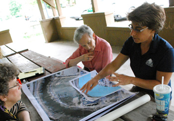
Ann Arbor park planner Amy Kuras, right, shows maps of Riverside Park to neighbors who came to an information meeting on Tuesday evening at the nearby Island Park. Sitting next to her is Eliana Moya-Raggio, a resident of Wall Street. The smaller map is an overlay showing how a lot of the park, which is located next to the Huron River, is in a floodplain. (Photos by the writer.)
Park planner Amy Kuras described the park’s entrance off of Wall Street as “falling apart,” and talked through some of the proposed changes of the project. The two main changes involve relocating a parking lot and repaving Canal Street, a narrow lane that runs parallel to the park and leads to the back of the University of Michigan’s new Kellogg Eye Center building.
The project is one of many slated for fiscal year 2012 and outlined in the recently updated Parks & Recreation Open Space (PROS) plan.
Residents generally expressed support for the project, and gave suggestions for improvements. During the hour-long discussion they also raised other concerns not directly tied to the park, including increased traffic along Wall Street, additional parking lots planned by UM, and noise from delivery trucks traveling along Canal Street to Kellogg Eye Center. Similar concerns had been raised by some of these residents nearly three years ago, at a December 2008 meeting with university officials regarding planned parking along Wall Street.
Tuesday’s conversation also touched on topics that affect the surrounding area, including the need for better connections to the Border-to-Border trail system, and the status of changes planned at the Argo headrace. The city had expected to receive a state permit earlier in the day so that work could begin on the headrace, but Kuras reported that by late afternoon, it still hadn’t arrived. [Responding to a follow-up email from The Chronicle, parks & rec manager Colin Smith reported that the permit has now been received, and work on the headrace will begin on Thursday, Aug. 25. For details of that work, see Chronicle coverage: "Action on Argo Headrace, Trails Near Fuller" ]
The Riverside changes are among several slated for the city’s current fiscal year, paid for out of the parks millage and outlined in the PROS plan. Another forum is planned for Tuesday, Aug. 30 at Cobblestone Farm to talk about proposed improvements at Buhr Park.
Riverside Park: Proposed Changes
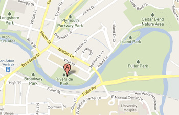
Riverside is one of the city’s oldest parks, acquired in the early 1900s and located in the Lower Town district, fronting a section of the Huron River. It includes a playground area, softball diamond and a field used by several rugby teams.
Nearly all of the 15-acre park is located in the river’s floodplain, and flooding is frequent. Eliana Moya-Raggio, who lives next to the park at the Riverside Park Place condominiums, reported that it’s been worse over the past two years because of heavier-than-usual rains.
In particular, the gravel parking lot near the park’s entrance is often covered with water, Kuras noted. On Tuesday evening, large puddles were still visible from recent rains.
The PROs plan listed the Riverside parking lot as an infrastructure need, and parks staff included it in the action plan for fiscal year 2012, which began July 1, 2011. The plan called for: (1) repaving the path and drive entry to create a separation between the path and road; (2) paving the parking lot; and (3) creating a rain garden.
However, rather than keeping the lot where it’s currently located, Kuras suggested moving it to slightly higher ground at the opposite end of Canal Street, on the west side of the softball diamond. That would likely mean a rain garden wouldn’t be necessary. Feedback from residents indicated support for that move, and a preference for making the new lot parallel to Canal Street – rather than an elongated lot jutting into the park. [.pdf of map showing proposed changes]
Kuras noted that the existing lot is used by UM employees, and she’s exploring the possibility of negotiating for the university to lease the new lot during the day. Currently, there’s no lease arrangement for the Riverside parking lot, though UM does lease other lots from the city – most notably a surface lot at Fuller Road, where the proposed Fuller Road Station parking structure is planned.
Stephanie Munz recommended keeping a few spaces at the location of the current lot, for fly fishermen who use that nearby portion of the Huron River. It would be less of a walk for them, she noted. Kuras said another option would be to put a couple of spots along Canal Street.
In addition to moving and paving the parking lot, other proposed changes at the park include:
- Removing and/or relocating the lights at the current parking lot.
- Moving the park’s sign to the opposite (east) side of the entry drive, for better visibility.
- Adding curbs along the entrance and possibly extending the curbs along Canal Street. There are no curbs now on Canal or the entrance.
- Requesting that trees at the entrance be trimmed. Residents have planted a garden on the west side of the entrance, but overgrown trees and bushes have prevented it from getting sufficient light.
Kuras added the caveat that the amount of work will depend on costs and available funding. She said there’s a $175,000 budget for Riverside improvements, funded by city’s park maintenance and capital improvements millage. Canal Street repaving will be paid for by the city’s street millage.

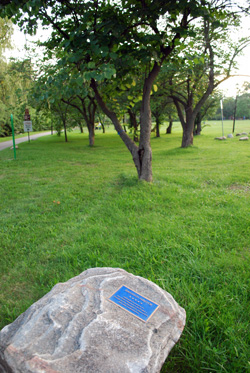
A redbud grove at Riverside Park. The plaque in the foreground notes that the grove was planted in memory of World War I veterans from Ann Arbor, paid for by the Elizabeth R. Dean Fund and other contributions. On the left is a path running through the park next to the Huron River.
Other Issues: Argo, Trails
At Tuesday’s meeting, several questions were raised that were unrelated to the Riverside improvement project. In response to one question, Kuras clarified that a temporary canoe launch at the park will be removed as soon as work on the Argo headrace is completed, likely by the 2012 season.
Currently, because of a state-mandated reconstruction of the headrace, there’s no access between the city’s Argo canoe livery and the downstream section of the Huron River. A temporary launch at Riverside allows canoeists to put in to the river below Argo dam. The Argo livery is available for canoeing and kayaking on Argo Pond and upstream. [The park advisory commission was updated on the Argo headrace work at their Aug. 16 meeting. See Chronicle coverage: "Action on Argo Headrace, Trails Near Fuller" ]
At one point in the meeting, Kuras expressed dismay that whenever she had visited Riverside Park, she rarely saw it being used by people other than teams that played on the fields. Residents assured her that the park was well-used by walkers, joggers and bicyclists. UM employees also use it during the day on breaks and during their lunch hours, Kuras was told. And many people are just passing through the park, on their way to other destinations.
That final observation led to a discussion about how the Riverside Park path fits in to a broader trail network throughout the city’s park system.
By way of background, access to Riverside Park is addressed in the city’s master plan, in a section on the Lower Town district:
Access to Riverside Park: Riverside Park was acquired by the City of Ann Arbor in the late 1920’s. Public pedestrian and bicycle access points to Riverside Park should be provided from at least the following places: a) the future pedestrian bridge over the Huron River near Broadway Bridge connecting to Broadway Park [that pedestrian bridge is now completed], b) from the Huron River Trail under Broadway Bridge, c) through the Detroit Edison site where Canal Street turns toward Wall Street, d) from the University District at two access points, and e) from the Huron River Trail near Wall Street. Access points should be clearly identified, well landscaped, properly lighted, and designed to encourage pedestrian access to the Riverside Park. Canoe/kayak access should be provided along the Huron River near the Detroit Edison Building to encourage marine access to Lower Town.
Kuras pointed out that when Maiden Lane bridge was built, the design included room for future trails to go under the bridge. It has never been fully developed, however, and the walkway is overgrown with plants and is a hangout for the homeless, she said.
The entire intersection at Maiden Lane, Fuller Road and East Medical Center drive is a “conundrum,” Kuras said, and parks staff are exploring ways to improve the area for pedestrians and bicyclists.
Tim Mortimer said he hoped to see a pedestrian bridge over the Huron River at the east side of Riverside Park, similar to the one at Broadway. When he noted that in the past there was a bridge crossing the river at Wall Street, Stephanie Munz pulled out her iPhone and produced a picture of it – there’s a photo of the old Wall Street bridge hanging at the Potbelly sandwich shop in downtown Ann Arbor, and she’d taken a picture of that photo.
Other Projects: Buhr Park
Changes are also in the works at Buhr Park, and a public input meeting for that project will be held on Tuesday, Aug. 30 at 7 p.m. at the Cobblestone Farm barn, 2751 Packard Road. A needs assessment listed in the PROS plan calls for several changes to Buhr Park, including:
- Provide inter-connecting pathway system to provide pedestrian access from the surrounding neighborhoods.
- Light the tennis courts.
- Construct new picnic pavilion with added picnic opportunities.
- Provide new wayfinding signage.
- Continue implementation of the goals and elements as identified in the Buhr Park stormwater management plan.
- Renovate entry road and parking lots.
For fiscal year 2012, a total of $250,000 is earmarked for the Buhr Park entry drive and pool/arena parking lot, and the Riverside Park entry drive and parking lot. [.pdf of FY 2011-2015 parks project list from the updated PROS plan]
The Chronicle relies in part on regular voluntary subscriptions to support our coverage of local government and civic affairs, including the Ann Arbor parks. Click this link for details: Subscribe to The Chronicle. And if you’re already supporting us, please encourage your friends, neighbors and colleagues to help support The Chronicle, too!


