


Burrowing Under Railroad Berm: Feasible?
On Wednesday, Ann Arbor city staff led a tour of property starting from the city-owned 721 N. Main site, northwards to the entrance ramp of M-14. On the tour were some members of a recently established North Main-Huron River corridor task force.

View of Depot Street from the south. The railroad track curves northward as it passes by Argo Dam, visible at the top of this image.
They were briefed on the status of the 721 N. Main property’s status with respect to potential environmental contamination – which is apparently less certain than what’s been portrayed recently by elected officials.
Task force members were also briefed on a related project that’s in its initial stages: a feasibility study for opening up the railroad berm separating the area south of Depot Street (including 721 N. Main) from the Huron River. The railroad tracks run along the top of the berm. The idea is to study the possible impact of replacing the solid berm – which acts as a dam for stormwater flow from the Allen Creek creekshed – with a culvert or a trestled system for suspending the tracks.
The primary impetus behind the berm project is stormwater management and flood mitigation. That’s reflected by the fact that the source of funds for the roughly $50,000 feasibility study would be from the city’s stormwater utility. The feasibility study would move ahead only if it’s approved by the city council, which will likely have the item on its agenda in about two months.
But the railroad berm study also has implications for pedestrian connections and riverside access – which the task force is supposed to study. The task force is asked to create a vision that, among other things, improves pedestrian and bicycle connections to Bandemer Park and increases public access to riverside parks.
So the railroad berm feasibility study has been coordinated with the goal of pedestrian accessibility. The RFP (request for proposals) for the study includes among its tasks a study of the potential for non-motorized access through the railroad berm.
The problematic character of pedestrian movement on the North Main corridor was evident during the July 25 tour. As the tour group made its way northward toward the M-14 entrance ramp, it repeated a pattern of fracturing into smaller clusters and re-grouping. That was partly a function of the size of the group (about 10 people), but also the corridor itself.
The relatively narrow walkable space – between the road to the left, and fences, buildings or vegetation on the right – features sidewalk slabs in need of repair and sections of dirt path that require single-file passage. Noise from rush hour traffic made conversation difficult along the way.
A year from now, on July 31, 2013, the task force is supposed to deliver its report on a vision for the corridor. Earlier than that, by the end of 2012, the task force has been asked to provide a recommendation on the use of 721 N. Main.
For task force members and members of the public, the same tour will be repeated on Aug. 1, starting at 5 p.m. from 721 N. Main.
721 N. Main
The July 25 tour began at the city-owned 721 N. Main site. City staff discussed two issues with task force members: where the floodway and floodplain lines are for the property; and the status of the site’s environmental clearance.
721 N. Main: Environmental
Compared to 415 W. Washington – another city-owned property that’s the focus of attention regarding its future disposition – 721 N. Main has been portrayed by mayor John Hieftje at recent meetings of the city council as not suffering from environmental contamination. And that’s the basis of a decision to try to make 721 N. Main the city’s first greenway park – an effort that would be supported through an eventual grant application by the city to Michigan’s Department of Natural Resources Trust Fund.
It’s the annual spring application deadline for the DNR trust fund grant that is driving the earlier timeline for the task force recommendation on 721 N. Main – Dec. 31, 2012, instead of six months later for a recommendation on the whole North Main-Huron River corridor.

Fluid lines formerly used for vehicle repair in 721 N. Main building, which previously served as the city's vehicle maintenance and repair facility.
But during the tour, city environmental coordinator Matt Naud addressed the possible perception that the 721 N. Main site has an environmental clearance and the idea that it has been certified as not contaminated. He traced that perception to the fact that the city had removed some underground gas storage tanks from the site – and for the confined area of those tanks, the soil had been remediated to the highest standard. So for the contamination that was known for a fact at 721 N. Main, Naud said, it had been cleaned up. But there was potentially contamination that was unknown in the rest of the site.
For the site as a whole, Naud told the group, 721 N. Main has not had a phase 1 environmental survey done – to study the history of past uses. Phase 2/3 environmental surveys would establish what contaminants are present, if any, and at what levels and locations.
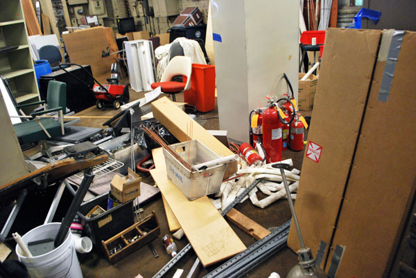
From the quick peek the tour group was given inside the main building at 721 N. Main, the past use of that building as a vehicle maintenance and repair facility indicates the potential for lingering contamination at the site. Aside from possible actual environmental contamination, the building is filled with clutter, including the city councilmembers’ old chairs that were retired from service in May 2011.
Naud also indicated that the Allen Creek creekshed, as the creekshed with the most impervious surface in Ann Arbor, is also likely the “dirtiest.” And any environmental contamination from other sites in the creekshed would naturally migrate to the Allen Creek area – on which the 721 N. Main parcel sits. [The Allen Creek is conveyed underground through a pipe that exits into the Huron River just below the Argo Dam.]
721 N. Main: Floodplain and Floodway
Jerry Hancock, the city’s stormwater and floodplain programs coordinator, also accompanied the tour group. He reviewed the status of a grant from the Federal Emergency Management Agency (FEMA) to demolish two of the buildings at the 721 N. Main site – those that are located in the floodway. The main building is in the floodplain, not the floodway, and is not included in the FEMA grant, which has been awarded and is worth around $100,000. The main building wasn’t included, he said, due in part to the fact that there’s been no public process around what the future of the building should be.
.")
The 721 N. Main parcel is west of Main Street. The main building on the site is oriented north-south, visible just north of the blue-shaded area (the FEMA floodway) and inside the green area (the FEMA floodplain). The FEMA grant for demolishing buildings at 721 N. Main does not include the main building. (Links to higher resolution image.)
Although the grant for demolishing buildings at 721 N. Main had already been awarded by FEMA, Hancock indicated that a delay by the Michigan Dept. of Transportation was long enough that the city’s All-Hazard Plan (for flood mitigation) had expired in the interim. The city is in the process of getting that plan renewed. The receipt of the FEMA funds is contingent on having an up-to-date All-Hazard Plan.
Removal of structures in the floodway – like the two buildings on the 721 N. Main site – is part of the city’s general strategy to reduce flood risk throughout Ann Arbor. Responding to questions from the tour group, Hancock explained that the FEMA flood maps aren’t merely an indicator of low areas – that is, the maps do not simply provide a topographical survey. Although the topography is a significant component of the data that factors into drawing flood maps, he said, the impact of built structures can be to push water into higher elevations.
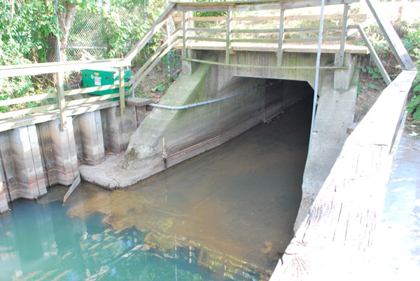
Railroad Berm Feasibility Study
Hancock also briefed the tour group on a feasibility study for a project near Depot Street, that – if eventually constructed – could have an impact on the floodway maps for the area as far away as 721 N. Main. The project is also potentially connected to improvements in non-motorized transportation.
The idea is to open up some portion of the berm that the railroad track sits on – between Depot Street and the Huron River – to allow a less impeded flow of stormwater into the Huron River. It’s one of 56 different specific projects listed out in the city’s flood mitigation plan:
Project 51: Railroad Berm Fill Removal. Examine ways to remove the berm located between Depot St. and the Huron River, as well as other portions of the railroad berm in the Allen Creek corridor, to allow floodwater to travel to the river without a major barrier impeding the flow, acting like a dam. Examine the costs of creating a terraced rail system. Compare costs estimates to complete project with the estimated costs of removal/relocating
The city issued an RFP (request for proposals) with a deadline for response of June 25, 2012: “Allen Creek Railroad Berm Opening Feasibility Study” Representatives from 10 different firms attended a pre-bid meeting on June 12, 2012. The city received proposals from six of them.

The railroad track berm from the Depot Street side of the track, looking southeastward. The Broadway bridges are visible in the distance.
The top two firms in the scoring system were OHM and Spicer Group. The five tasks identified in the RFP are: (1) information gathering; (2) option development; (3) option analysis and stakeholder engagement; (4) conceptual design development; and (5) benefit-cost analysis.
At the city council’s March 19, 2012 meeting, public services area administrator Craig Hupy had responded to questions about flooding along Depot Street during a recent rainstorm. On that occasion, Hupy mentioned the physical, dam-like barrier presented by the railroad berm as a challenge in any improvements to the city’s ability to improve stormwater flow.
Hupy is serving as head of public services on an interim basis, after Sue McCormick’s departure. His permanent position is head of the “systems planning” unit for the city. Systems planning includes not just stormwater manager Jerry Hancock, but also the city’s transportation program manager, Eli Cooper. So according to Hancock, staff were easily able to see a potential connection between the flood mitigation function of a railroad berm project and the potential for non-motorized transportation access to the river, for pedestrians and bicyclists.

The desire for pedestrian and bicycle access across the railroad track was identified separately from the impact that opening the berm could have on flood mitigation. Excerpt from the city's 2007 Non-Motorized Transportation Plan. (Image links to higher resolution file.)
One of the criteria to be applied in task #3 of the RFP, the option analysis, is this: “Possibilities for a shared-use non-motorized path through berm.” And as a part of task #4, the consultant is supposed to: “Develop a design concept for a shared-use non-motorized path through the berm and determine the safety issues due to the floodplain function.”
Hancock described to the tour group how he would be meeting the following morning with one of the respondents to the RFP. That meeting was with OHM, the city’s preferred firm as a result of the RFP review process, and was meant to finalize the details of the scope of work. If OHM and the city can settle on those details, OHM would be hired only after a contract is approved by the city council. It’s expected that the feasibility study would be on the city council’s agenda in about two months. Hancock told The Chronicle that the $50,000 project budget for the study would be drawn from the city’s stormwater utility fund.
On approval by the city council, the project would be completed in a timeframe that Hancock estimated at around 4-6 months.

FEMA flood map that includes the area of study for the railroad berm feasibility study.
Depending on the result of the feasibility study and the resulting concept that the consultant produces, it could become a project that is added to the city’s formal capital improvements plan (CIP). The CIP includes projects the city has identified as useful, even if a funding mechanism for the actual capital project has not been identified.
Hancock told The Chronicle that the capital project itself would be very expensive – with costs driven in part by the fact that it involves a working railroad. Although there’s a pending transaction to transfer ownership from Norfolk Southern to the Michigan Dept. of Transportation, he said, the rail company will continue to have access rights to run its trains under whatever agreement is struck with MDOT.
The Chronicle could not survive without regular voluntary subscriptions to support our coverage of local government issues. Click this link for details: Subscribe to The Chronicle. And if you’re already supporting us, please encourage your friends, neighbors and colleagues to help support The Chronicle, too!
Thank you SO much for this information! I live on Depot (wave to my house in the picture!) and I hadn’t heard about this.
(I still wish I was on the Task Force, grumble grumble 1st world problems :))
That area along the river seems to have SO MUCH potential! I just got back from a trip up north where I saw a ton of awesome shops, restaurants, cafes, etc. along bodies of water. I understand the flood plain issue (my wallet does too, as it says goodbye to about $100 per month in flood insurance), but with all of our smart people working on this, I would hope that we could figure out something.
I realize the I am biased, but I think this is the absolute best place to live in the city (flood insurance costs notwithstanding :))–we are less than a ten minute walk to downtown and Argo Cascades are right across the street. I would hope that local businesses and entrepreneurs would want to set up shop in this lovely area.
Meta: while the lightbox display of images is cool and modernistic, it makes it hard to read the way I like, which is to have the image open in another tab and flip back and forth between article and image. Am I the only one who feels this way? How hard would it be to write a Greasemonkey script or something that would disable the lightbox and restore the old way of viewing images?
Rod, I don’t know what browser you’re using, but Firefox for me will open the image in a new tab if I middle-click it.
Jim, I’m using Firefox too, and that’s usually true, but the lightbox script defeats it (for me, at least). Does it work for you on the first two images in this article?
With the visual aids provided in the article, this is probably a good opportunity to clarify something in regard to the whole DTE property/Amtrak discussion.
There is a large parcel of land across the tracks from the Amtrak station, currently used for passenger parking, that is already owned by Amtrak. (Parcel ID# 09-09-20-403-024)
The parcel is shaped like a human arm, bent slightly up at the elbow. The “upper arm” is the parking area that runs parallel to the tracks (but the parcel actually extends much further to the west than the end of the north parking area–to a line even with the parking lot on the Depot St. side of the tracks, where the potential underpass is indicated in the one image). The “forearm” section runs along Broadway and provides additional parking and vehicle access from Broadway. The parking area is visible on the right of the aerial photo at the top of the article, and the parcel outline is visible in the FEMA map at the bottom of the article. (Look for the arm shape that sits in the north corner of the intersection of the tracks and Broadway.)
I raise this point, because much discussion has already taken place about the future of the DTE parcel–including possible park use, which is great. Others have pointed out that the existing Amtrak station, if need be, ought to be renovated and expanded where it sits, rather than building a brand new one in Fuller Park. That expansion might need to include use of land on the north side of the tracks.
Those who are in favor of building a new Amtrak station in Fuller Park have tried to poo-poo the current location by saying it’s too small and partially in the floodplain. When it has been suggested to them to use some land on the north side of the tracks for Amtrak expansion, the implication has been that the whole site is one parcel belonging to DTE, and that it is likely to all become a park.
I thought it was important to clarify that there is already a sizable piece of land on the north side of the tracks that is currently owned by Amtrak, and this is land that will not be included in any DTE/City deal to acquire property for a park in this location.
Re: #5
Mr. Whitaker is correct in stating that current Amtrak parking on the north side of the tracks belongs to Amtrak. I’m not aware that anyone has suggested otherwise, but will allow that any of us can be confused if we haven’t looked at the parcel maps and other things.
It’s also correctly stated that the parcel owned by Amtrak is larger than its current parking footprint. Seeing that parcel with an overlay of the most recent FEMA flood maps can help illuminate the issue.
Here’s a link to a map I created in order to see the overlay: [link]
and another to the FEMA flood map of the site: [link].
The most recent comments I’ve heard from folks at DTE and the City reinforce my impression that the City will not have access to the entire DTE site as a park. The portion of the DTE site in the flood plain, and a strip of land along the river, are most likely to be used to expand our park system.
“Mr. Whitaker is correct in stating that current Amtrak parking on the north side of the tracks belongs to Amtrak. I’m not aware that anyone has suggested otherwise, but will allow that any of us can be confused if we haven’t looked at the parcel maps and other things.”
From the Chronicle, June 11, 2012:
“Kunselman asked if the MichCon site on Broadway would be included in the further study? Cooper indicated that the analysis would include the prevailing conditions at the time of the study. Right now, Cooper said, MichCon has not made the land immediately adjacent to the Amtrak station available. He said that as part of a design workshop, MichCon might be looked at to see if it could remedy any of the issues at that location. But that parcel was not one of the 15 sites that the city had looked at starting four years ago, he said. Subsequently, the staff reviewed privately-owned properties, and two rose to consideration – one was a private manufacturing plant, and the other was the MichCon property.”
Mr. Cooper, at least in the Chronicle’s coverage of this meeting, appears to make no attempt to clarify that Amtrak owns the property immediately adjacent to the tracks. (This might have explained why MichCon had not made it available.)
As I commented below that article, the FRA’s own regulations require that before using a “protected property,” like a locally-designated park such as Fuller, there must be a determination made that there is “no reasonable alternative” to using that protected property.
It doesn’t seem to me that we’re off to a very good start, to say the least, on making a quality, objective assessment of the viability of the existing station location, especially if the man in charge is either unaware of who owns the parcels in question, or worse, is not being forthcoming with City Council and the public about what he knows.
Re: #7
Sorry, Tom. This may be one of those issues that seems to be open to interpretation. What land was exactly in question when Mr. Kunselman asked about the MichCon land?
I suspect, although I do not know, that Mr. Cooper was referring to the land that is adjacent to that owned by Amtrak. Because the land in discussion was that owned by MichCon, he is likely to have been talking *only* about the land owned by MichCon. I’ve observed that Mr. Cooper is even more literal than I am.
I doubt that he was confused, and I know that I wasn’t.
Due to flood plain/flood way issues, only part of the Amtrak-owned property and part of the MichCon/DTE-owned property is easily available for new construction. When I heard the question, I thought about that land above the flood plain that MichCon owns.
I think one would have to have considerable knowledge of this area to make the interpretation that “immediately adjacent to the Amtrak station” meant “immediately adjacent to the north Amtrak parking lot.” I do appreciate that Sabra goes out of her way to acquire this kind of knowledge in advance of council decisions, making it easier for her to follow along, but I wonder how many people knew that Amtrak owned anything on the other side of the tracks–even those at the Council table? Until very recently, I assumed that Amtrak only leased the lot from MichCon/DTE and that the entire parcel between the river and the tracks was owned by MichCon/DTE. Perhaps I’m the only one in town who assumed this.
While we’re on the subject, I’m only aware of a restriction on new RESIDENTIAL construction in floodways/floodplains, not other uses. As a matter of fact, the newer office building just west of here on Depot Street, ironically occupied by the offices of SmithGroup/JJR, is built in the floodWAY, not just the floodplain. What about the YMCA? Surely, if these heavily-used buildings with consistent and significant daily occupancy can be built in floodways/floodplains, then portions of a train station complex, with transient customers and only occasional trains can be too? Heck, if there was a flood of this significance, would the trains even be running at all (regardless of where the station was located)?
Railroad trackbeds are often “contaminated” with chemicals spilled from tank cars and bulk carriers, drippings from the trains, and generations of heavy applications of herbicides. Digging up berms would probably mean huge costs of disposal of “toxic” material and big fees for environmental consulting leaches. Best to leave them alone for as long as possible.
The Gandy Dancer building might make a nice train station.
Jim wins the thread.
Agreed.
Agree the Gandy Dancer is a ‘natural’ for a train station.
A opening at the tracks would be great for floodplain reduction and alternate transportation access to the river from the Allen’s Creek Greenway.
The mayor’s comments on a Greenway need to be taken with a grain of salt. As his notion may simply be a thin walk down the center with development all around that is in the floodplain now but with a meaningful watershed study, the city refuses to do, would show it in the floodway.
Once again we have no watershed involved citizens on this taskforce and no greenway involved citizens.
@10 – However contaminated the railway berm might be, if it was acting as a dam to hold back floodwater from a major storm, then a lot of those contaminants could be washed into the Huron River. Replacing ~5% of the berm with culverts might greatly reduce the potential for it to either cause flooding or spread contaminants, but at far less cost than replacing the whole berm with a trestle.
Of course, leaving 95% of the (plausibly) contaminated berm in place would not reduce the total cost by 95%. And minimizing the grief and costs from stupid bureaucracy (the disease behind those consulting leeches) could easily be beyond the City’s competence or political clout.
I attended the second tour. It was noted by staff at the tour, when I asked for clarification, that the current (new) Allen’s Creek Floodplain Maps from FEMA are ‘loosely calibrated on 1968 data’. This is mainly 1968 anecdotal data. Meaning they are not very predictive of flood hazard.
There was some discussion at the tour about converting the large building on the north side of the lot next to the drawn floodway to residential. Without a better study of the floodplain this would be ill advised in the least, and irresponsible to put more unsuspecting people in harms way at the worst. I would say this building is way in the floodway with a modern map. The city has refused for years to do a meaningful effort to map this dangerous floodplain!
I should note that the FEMA hired consultants StanTec, from Lexington KY, to coordinate producing the new maps redid the ‘new’ FEMA maps for Lexington and found a much larger floodplain. and now it is forbidden to build anything in the new locally redrawn floodplain!
Tom W., you’re right that 201 Depot, the office building currently occupied by JJR, is in the floodway. Though the state DNR approved it, we had a huge fight getting it built, because our then-council rep didn’t want it, and spread misinformation that if it were permitted to proceed, everyone in the city could lose their flood insurance. (Didn’t happen.)
Dave may know more about this, but I think that the city has since made it more difficult, if not impossible, to build in the floodway.