Stories indexed with the term ‘FEMA flood maps’

Avalon Housing: Near North Won’t Work

In a letter sent to Ann Arbor councilmembers and other government officials, Avalon Housing‘s senior developer Michael Appel has announced that the Near North affordable housing project will not move forward. The development team has determined that the project, which was to include 39 new affordable housing units, 16 of them as supportive housing, is not feasible as planned. [.pdf of letter from Michael Appel]

A change to the FEMA flood maps is highlighted in Appel’s letter as a crucial factor in the inability of the project to move forward. The new maps, adopted in 2012, show an expanded floodway, which cuts across the corner of the parcel. That mean that federal funds – part of the project’s financing … [Full Story]

Burrowing Under Railroad Berm: Feasible?

On Wednesday, Ann Arbor city staff led a tour of property starting from the city-owned 721 N. Main site, northwards to the entrance ramp of M-14. On the tour were some members of a recently established North Main-Huron River corridor task force.

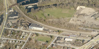
BirdsEye view of railroad berm

View of Depot Street from the south. The railroad track curves northward as it passes by Argo Dam, visible at the top of this image.

They were briefed on the status of the 721 N. Main property’s status with respect to potential environmental contamination – which is apparently less certain than what’s been portrayed recently by elected officials.

Task force members were also briefed on a related project that’s in its initial stages: a feasibility study for opening up the railroad berm separating the area south of Depot Street (including 721 N. Main) from the Huron River. The railroad tracks run along the top of the berm. The idea is to study the possible impact of replacing the solid berm – which acts as a dam for stormwater flow from the Allen Creek creekshed – with a culvert or a trestled system for suspending the tracks.

The primary impetus behind the berm project is stormwater management and flood mitigation. That’s reflected by the fact that the source of funds for the roughly $50,000 feasibility study would be from the city’s stormwater utility. The feasibility study would move ahead only if it’s approved by the city council, which will likely have the item on its agenda in about two months.

But the railroad berm study also has implications for pedestrian connections and riverside access – which the task force is supposed to study. The task force is asked to create a vision that, among other things, improves pedestrian and bicycle connections to Bandemer Park and increases public access to riverside parks.

So the railroad berm feasibility study has been coordinated with the goal of pedestrian accessibility. The RFP (request for proposals) for the study includes among its tasks a study of the potential for non-motorized access through the railroad berm.

The problematic character of pedestrian movement on the North Main corridor was evident during the July 25 tour. As the tour group made its way northward toward the M-14 entrance ramp, it repeated a pattern of fracturing into smaller clusters and re-grouping. That was partly a function of the size of the group (about 10 people), but also the corridor itself.

The relatively narrow walkable space – between the road to the left, and fences, buildings or vegetation on the right – features sidewalk slabs in need of repair and sections of dirt path that require single-file passage. Noise from rush hour traffic made conversation difficult along the way.

A year from now, on July 31, 2013, the task force is supposed to deliver its report on a vision for the corridor. Earlier than that, by the end of 2012, the task force has been asked to provide a recommendation on the use of 721 N. Main.

For task force members and members of the public, the same tour will be repeated on Aug. 1, starting at 5 p.m. from 721 N. Main. [Full Story]

Ann Arbor Takes Late Bus to Transit Accord

Ann Arbor city council meeting (March 5, 2012): The council’s meeting did not conclude until almost 1 a.m., prompting resident Thomas Partridge to remark during public commentary at the conclusion of the meeting, “It’s almost time to plan for breakfast!”
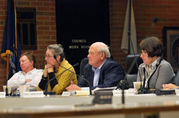
Sandi Smith, Sabra Briere, Tony Derezinski, Jane Lumm

Left to right: Councilmembers Sandi Smith (Ward 1), Sabra Briere (Ward 1), Tony Derezinski (Ward 2) and Jane Lumm (Ward 2). (Photos by the writer.)

The issue driving the lengthy meeting was an agreement between four different entities, including the city of Ann Arbor, that would set up a framework for a transition of the Ann Arbor Transportation Authority to a new funding and governance structure. The intent of transitioning to a new authority would be to provide increased transportation service both within the city of Ann Arbor as well as throughout Washtenaw County.

The Ann Arbor city council approved the agreement on Monday night on a 7-4 vote, after postponing it three times previously. That sets the stage for the city of Ypsilanti, Washtenaw County and the AATA to approve it as well. Even after approval by those three entities, several steps would remain before a new transit authority, incorporated under Michigan’s Act 196, could take over transportation services from the AATA.

The council considered several amendments to the agreement, but approved only two relatively minor, clarificational items. [.pdf of agreement as amended]

Toward the end of the meeting, the nomination of University of Michigan planner Sue Gott to the AATA board was given spirited discussion by two councilmembers, but was ultimately confirmed on a unanimous vote.

Falling victim to the lengthy deliberations on the transit agreement was a resolution that would direct the city attorney to delay enforcement of medical marijuana laws for local dispensaries, except for zoning violations. A vote on that resolution was postponed without deliberation, due to the late hour. That resolution comes in the context of a recommendation from the city council’s medical marijuana licensing board, currently pending with the council, to award the first 10 medical marijuana licenses under local legislation enacted last year.

Related to a different kind of licensing, the council approved a resolution that recommends non-renewal of liquor licenses for two establishments in Ann Arbor – Dream Nite Club and Rush Street. A hearing on the two licenses will be held on March 19, with the city council’s final recommendation to the Michigan Liquor Control Commission to be made that same day.

The council also passed several resolutions related to land and its use. The council approved the acquisition of another 58.85 acres under its greenbelt program, as well as the purchase of property on West Kingsley so that a long-vacant house there can finally be demolished. A rain garden is to be constructed on that parcel, because it’s situated in the Allen Creek floodway. In a related item, a new Federal Emergency Management Agency (FEMA) flood map was also given final approval by the council on Monday night.

The council gave initial approval to a revision of parking regulations in open space at the front of land parcels, but postponed any action on a proposed revision that would eliminate a requirement on landscape buffers in areas zoned R4C (multi-family residential).

Receiving approval from the council were a total of nearly $1.7 million in renovations to several of the city parks. The funding includes improvements to ballfields at Veterans Memorial Park, Southeast Area Park and West Park, as well as upgrades to roads and paths at Buhr Park and Cobblestone Farm.

The council also approved the issuance of $120 million in revenue bonds for the reconstruction of the city’s sewage treatment facilities, long planned and in the works. [Full Story]

Column: Digital Information Flood

At the city council’s Jan. 23, 2012 meeting, Dan Rainey – the city of Ann Arbor’s head of information technology – was on hand to receive an award recognizing the city’s use of digital technology. The award was for 5th place in the 2011 edition of the Center for Digital Government’s Digital Cities Survey.

Parcel Flood

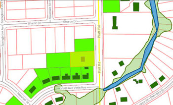
Screenshot from the city of Ann Arbor and Washtenaw County mapping website. It shows the new floodway and floodplain boundaries for the new FEMA maps, highlighting the buildings and parcels that are no longer in the floodplain, according to the new maps. The parcel with extra highlighting (yellowish green) is one of special interest for this column.

Yet among the nearly 12,000 words in The Chronicle’s report from that meeting, there’s no mention of the city’s Digital Cities award. The decision not to include that award in the meeting report was not one about which I agonized; it was not made on the basis of some high-minded journalistic principle. From a purely practical point of view, the award was likely a victim of my finite stamina for writing about a city council meeting.

But one reason I don’t mind omitting that kind of award from a meeting report is that it really does not matter to me where Ann Arbor ranks on that survey. What matters to me is the fact that the city’s investments in the realm of digital technology make life in Ann Arbor as a local journalist easier than it would be otherwise.

And that, I think, is best illustrated with a specific example. It’s an example I stumbled across a couple of months ago. But because it overlaps with two agenda items on the city council’s next meeting, on Feb. 21, I thought now would be a good time to share it with readers. One of those agenda items involves demolishing derelict houses, and the other involves the Federal Emergency Management Agency (FEMA) flood maps.

This tale begins on Facebook and ends in the bucket of a big yellow backhoe. [Full Story]