Column: Digital Information Flood
At the city council’s Jan. 23, 2012 meeting, Dan Rainey – the city of Ann Arbor’s head of information technology – was on hand to receive an award recognizing the city’s use of digital technology. The award was for 5th place in the 2011 edition of the Center for Digital Government’s Digital Cities Survey.

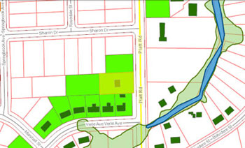
Screenshot from the city of Ann Arbor and Washtenaw County mapping website. It shows the new floodway and floodplain boundaries for the new FEMA maps, highlighting the buildings and parcels that are no longer in the floodplain, according to the new maps. The parcel with extra highlighting (yellowish green) is one of special interest for this column.
Yet among the nearly 12,000 words in The Chronicle’s report from that meeting, there’s no mention of the city’s Digital Cities award. The decision not to include that award in the meeting report was not one about which I agonized; it was not made on the basis of some high-minded journalistic principle. From a purely practical point of view, the award was likely a victim of my finite stamina for writing about a city council meeting.
But one reason I don’t mind omitting that kind of award from a meeting report is that it really does not matter to me where Ann Arbor ranks on that survey. What matters to me is the fact that the city’s investments in the realm of digital technology make life in Ann Arbor as a local journalist easier than it would be otherwise.
And that, I think, is best illustrated with a specific example. It’s an example I stumbled across a couple of months ago. But because it overlaps with two agenda items on the city council’s next meeting, on Feb. 21, I thought now would be a good time to share it with readers. One of those agenda items involves demolishing derelict houses, and the other involves the Federal Emergency Management Agency (FEMA) flood maps.
This tale begins on Facebook and ends in the bucket of a big yellow backhoe. [Full Story]


