How Low Can Argo Flow Go?
The full flow to the Argo Cascades was restored on Thursday, Aug. 2, 2012, according to a city of Ann Arbor press release, and the city is again renting kayaks and inner tubes for the series of pools and drops that offer an alternative boatable channel around the Argo Dam. Dry conditions had led the city to reduce the flow to the cascades during the previous week, on July 26.

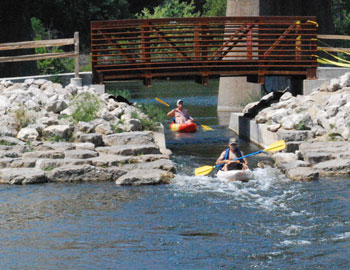
View looking north through the entrance to the Argo Cascades on Aug. 3, 2012. (Photos by the writer.)
Because the flow to the new recreational amenity was reduced, but not shut off completely last week, some confusion ensued about what measures, if any, the city had taken and why, and what the impact of those measures was.
At issue is the flow through two different channels – Argo Cascades on the one hand, and the stretch of the Huron River immediately below the Argo Dam on the other. The two channels are parallel and are separated by an earthen embankment, until they join together at a point just upstream of the Broadway bridge.
Downstream from that confluence, and near the Maiden Lane bridge, a U.S. Geological Survey gauge measures the total river flow.
Ostensibly, the planned reduction in flow to the cascades was to allow more water to flow through the dam-side channel, instead of passing through the Argo Cascades.
Based on a telephone interview with Molly Wade, unit manager for the city of Ann Arbor’s water treatment plant, here’s a summary description of what happened last week.
During the morning of July 26, city staff inserted a partial wooden stoplog at the entrance to the Argo Cascades. That evening, The Chronicle verified by visual inspection that the wooden stoplog was inserted in the slot. An intuitive “bathtub physics” expectation would have been to see no change in the gauge reading as a result of the partial stoplog insertion. That’s because whatever flow was previously going through the Argo Cascades would be expected automatically to flow through the dam-side channel.
That intuitive expectation was not met for two reasons. First, the Argo Dam is not a “spillover” dam, where the water flows over the top of the dam. So reducing the flow to the Argo Cascades would not “automatically” – in the bathtub physics sense – cause any additional flow through the dam-side channel. In order for the flow to increase through the Argo Dam, the dam’s gates – which are keyed to a pond-level gauge – would need to open wider.
So why didn’t the Argo Dam gates respond to what should have been a tendency for the Argo Pond level to increase? Ordinarily, you’d expect the Argo Dam gates would balance the lost flow downstream from the cascades with additional flow through the dam-side channel, thus maintaining the USGS gauge reading where it was – around 75 cfs (cubic feet per second). Instead, the gauge showed a drop to around 50 cfs.
That’s because upstream from Argo, at Barton Dam, the city staff was concurrently decreasing the opening to Barton Dam’s gates, in order to match the extremely low flow into Barton Pond. And reducing the flow at Barton ultimately reduced the flow to the river overall. A few days later, the pond levels at Argo and Barton rebounded, and the region enjoyed some, if limited, precipitation. And the flow rate as measured by the USGS Maiden Lane gauge started showing an incremental increase, to around 100 cfs.
By Friday, Aug. 3, the city of Ann Arbor had removed the partial stoplog at the cascades, and was back to renting kayaks for downstream trips through the pools and drops, all the way to the pond at Gallup Park.
The type of pattern for the increased flow in the Huron River, as measured by the USGS gauge, causes some continued concern by staff with the Michigan Dept. of Natural Resources and Dept. of Environmental Quality. The pattern is “saw-toothed,” which reflects the opening and closing of dam gates in response to a variation in pond levels.
After the jump, more detail is presented on last week’s events, and the pertinent legal constraints for dam operation. We also cover some related issues – concerning a permit that is currently being sought for construction of a whitewater area in the Huron River, near Argo Dam. That amenity is to be constructed in the dam-side channel at Argo, just upstream from the confluence of the river and the cascades. [Full Story]


