Ann Arbor Council: Land, Water, Buildings
Ann Arbor city council meeting (Feb. 21, 2012): Land use was one common theme that trickled through the city council’s relatively short meeting.

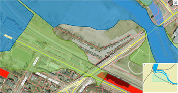
The Ann Arbor city council gave initial approval to new Federal Emergency Management Agency (FEMA) flood maps at its Feb. 21 meeting. The council briefly touched on the topic of the current location of the Amtrak train station, which is in the floodplain (green area). The dark red is a building (Gandy Dancer) that was previously not analyzed as within the floodplain, but now is analyzed as such – similarly for parcels colored bright red. (Image links to higher resolution file with legend.)
The council denied a rezoning request from the owners of Biercamp Artisan Sausage and Jerky, located on South State Street near the Produce Station, that would have allowed them to use the property for a retail operation larger than what currently exists. But the council did give initial approval to a rezoning request from the Society of Les Voyageurs that will allow the group to make an addition to their house, which is located near the Argo Dam.
At the other end of the spectrum from development, the council also took action that will allow the city to move quickly to demolish buildings that are derelict, posing a safety risk to the community. The council authorized the allocation of $250,000 from the general fund to pay upfront costs for the demolition of such structures. The city expects to be able to replenish the money out of a lawsuit settlement it won previously against the owner of the former Michigan Inn. The city will also eventually be able to recover its costs from property owners whose buildings require demolition.
Also related to possible future construction on land throughout the city, as well as the insurance for existing buildings, was the council’s initial approval of new federal flood maps. The most recent maps date from 1992. The new maps being considered for approval by the city were created out of a process begun by the Federal Emergency Management Agency (FEMA). Throughout the city, 452 structures are no longer analyzed as lying within a floodplain, while 88 buildings are newly analyzed as in a floodplain, according to the new maps.
Floods are one of the natural disasters that the city’s new emergency management director, Rick Norman, will be responsible for preparing the city to handle. The council formally authorized Norman’s appointment at their meeting.
In resolutions that required expenditures of funds, the council authorized additional outside accounting and legal expenses, as well as the painting and repair of equipment at the city’s water treatment plant.
In other business, the council passed a resolution in support of a clean air campaign, and authorized the closing of city streets for eight different upcoming events.
Two significant appointments were discussed at the meeting. The first was a mayoral nomination on which the council will be asked to take action at its next meeting – appointing Sue Gott, planner for the University of Michigan, to the board of the Ann Arbor Transportation Authority. The other was an appointment that has already been made by Gov. Rick Snyder – Joe Burke as judge to the 15th District Court. Burke was on hand to be introduced to the council. [Full Story]


