Michigan Presidential Primary: Voter Maps
Michigan’s Republican presidential primary held on Tuesday, Feb. 28 was won by Mitt Romney, with 41% of the Republican votes cast statewide – a close victory over Rick Santorum, who tallied 37.9%. Third-place finisher Ron Paul came in with 11.5%, roughly double the percentage he received in the 2008 edition of the race, which was won by Romney that year as well. The eventual Republican nominee in 2008, of course, was John McCain.

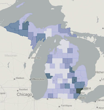
Map 1. Michigan 2012 presidential primary election – Democratic participation as a percentage of total turnout, by county. Details after the jump.
For Democrats, President Barack Obama was unchallenged in the Michigan primary this year, amid a political scuffle about whether the Democratic primary should even be held. With little at stake in terms of the choice of the Democratic nominee, it’s not surprising that the 2012 Democratic turnout was light, compared to 2008.
This year only 16% of participants in the primary voted on the Democratic side compared with 40% in 2008. That year Obama’s name did not appear on the Michigan ballot, which resulted in about 41% of Democratic voters selecting the “uncommitted” option, compared to roughly 55% who voted for Hillary Clinton. Part of the diminished Democratic turnout this year could have been due to Democrats crossing party lines to vote for Rick Santorum – based on the idea that Santorum would have less of a chance to defeat Obama in the general election.
In Ann Arbor, however, absentee Democratic voters participated in far greater relative numbers than their counterparts who went to the polls in person. Even in the more strongly Republican wards – Ward 2 and Ward 4 – almost 40% of the total primary turnout for absentee voters was on the Democratic side. In the other three Ann Arbor wards, Democratic absentee turnout was closer to 50%.
For readers already familiar with the general geographic distribution of voters who mainly vote Democrat or Republican, the results of the 2012 presidential primary in Michigan likely offer little to refute prevailing wisdom.
After the jump we take a geographic look at Democratic participation, as well as the performance of Romney, Santorum and Paul. We’ve mapped out results at the state level (by county), the Washtenaw County level (by township and city) and the city of Ann Arbor (by precinct). Statewide data is from the secretary of state’s office election results, while the data for jurisdictions within Washtenaw County is based on the county clerk’s election results. Mapping is done through geocommons.com with shape files available through the city of Ann Arbor. [Full Story]


