


How Low Can Argo Flow Go?
The full flow to the Argo Cascades was restored on Thursday, Aug. 2, 2012, according to a city of Ann Arbor press release, and the city is again renting kayaks and inner tubes for the series of pools and drops that offer an alternative boatable channel around the Argo Dam. Dry conditions had led the city to reduce the flow to the cascades during the previous week, on July 26.

View looking north through the entrance to the Argo Cascades on Aug. 3, 2012. (Photos by the writer.)
Because the flow to the new recreational amenity was reduced, but not shut off completely last week, some confusion ensued about what measures, if any, the city had taken and why, and what the impact of those measures was.
At issue is the flow through two different channels – Argo Cascades on the one hand, and the stretch of the Huron River immediately below the Argo Dam on the other. The two channels are parallel and are separated by an earthen embankment, until they join together at a point just upstream of the Broadway bridge.
Downstream from that confluence, and near the Maiden Lane bridge, a U.S. Geological Survey gauge measures the total river flow.
Ostensibly, the planned reduction in flow to the cascades was to allow more water to flow through the dam-side channel, instead of passing through the Argo Cascades.
Based on a telephone interview with Molly Wade, unit manager for the city of Ann Arbor’s water treatment plant, here’s a summary description of what happened last week.
During the morning of July 26, city staff inserted a partial wooden stoplog at the entrance to the Argo Cascades. That evening, The Chronicle verified by visual inspection that the wooden stoplog was inserted in the slot. An intuitive “bathtub physics” expectation would have been to see no change in the gauge reading as a result of the partial stoplog insertion. That’s because whatever flow was previously going through the Argo Cascades would be expected automatically to flow through the dam-side channel.
That intuitive expectation was not met for two reasons. First, the Argo Dam is not a “spillover” dam, where the water flows over the top of the dam. So reducing the flow to the Argo Cascades would not “automatically” – in the bathtub physics sense – cause any additional flow through the dam-side channel. In order for the flow to increase through the Argo Dam, the dam’s gates – which are keyed to a pond-level gauge – would need to open wider.
So why didn’t the Argo Dam gates respond to what should have been a tendency for the Argo Pond level to increase? Ordinarily, you’d expect the Argo Dam gates would balance the lost flow downstream from the cascades with additional flow through the dam-side channel, thus maintaining the USGS gauge reading where it was – around 75 cfs (cubic feet per second). Instead, the gauge showed a drop to around 50 cfs.
That’s because upstream from Argo, at Barton Dam, the city staff was concurrently decreasing the opening to Barton Dam’s gates, in order to match the extremely low flow into Barton Pond. And reducing the flow at Barton ultimately reduced the flow to the river overall. A few days later, the pond levels at Argo and Barton rebounded, and the region enjoyed some, if limited, precipitation. And the flow rate as measured by the USGS Maiden Lane gauge started showing an incremental increase, to around 100 cfs.
By Friday, Aug. 3, the city of Ann Arbor had removed the partial stoplog at the cascades, and was back to renting kayaks for downstream trips through the pools and drops, all the way to the pond at Gallup Park.
The type of pattern for the increased flow in the Huron River, as measured by the USGS gauge, causes some continued concern by staff with the Michigan Dept. of Natural Resources and Dept. of Environmental Quality. The pattern is “saw-toothed,” which reflects the opening and closing of dam gates in response to a variation in pond levels.
After the jump, more detail is presented on last week’s events, and the pertinent legal constraints for dam operation. We also cover some related issues – concerning a permit that is currently being sought for construction of a whitewater area in the Huron River, near Argo Dam. That amenity is to be constructed in the dam-side channel at Argo, just upstream from the confluence of the river and the cascades.
Insertion of the Cascades Stoplog
By way of basic geographical background, the city of Ann Arbor maintains a dam at Barton Pond that generates hydroelectric power and falls under the regulatory jurisdiction of the Federal Energy Regulatory Commission (FERC).

Huron River as it flows through the city of Ann Arbor.
Based on a 2009 letter from FERC to the city of Ann Arbor, the city operates Barton Dam under a May 4, 1982 FERC order that requires it to be operated in an “instantaneous run-of-river mode.” That is, the flow on the downstream side of the dam should exactly match the flow into the pond on the upstream side.
The FERC order requires implementation of a Michigan Dept. of Natural Resources (MDNR) requirement – maintaining either a minimum flow of 100 cfs or the amount that is flowing into Barton Pond, whichever is less.
Barton Pond is also the primary source of the city’s drinking water.
Argo Dam is about two miles downstream from Barton. It’s not regulated by FERC, because it does not generate any hydroelectric power. The city uses Argo Pond as a recreational amenity – maintaining a canoe livery there, renting boats for pond paddling as well as for trips down the Huron River to the pond at Gallup Park.
Previously the Argo-Gallup river trip required a portage. Paddlers would start from Argo Pond, navigate a short distance to the entrance to a headrace leading around the dam, then paddle along the headrace to a point where it spilled back into the river. That spillway was not boatable, and required the portage. Construction of the Argo Cascades, which opened for the first time this season, eliminates the need for a portage, and addressed the long, drawn out concern that the dam safety unit of Michigan’s Dept. of Environmental Quality had raised about the earthen berm separating the two channels.
On Wednesday, July 25, Sumedh Bahl – the city of Ann Arbor’s community services area administrator – indicated in an email the imminent closing of Argo Cascades the following day:
To comply with the Federal Energy Regulatory Commission and the MDNR minimum flow requirements across Barton and Argo dams, the low flow in the river has necessitated closing Argo Cascades. Presently it is planned to stop the flow through Cascades tomorrow [July 26] morning. Staff will continue to monitor river flows and the flow will be restored to the Cascades when flow in the river improves.
Based on the wording in Bahl’s email, the expectation was that the flow to the cascades would stop.

Argo Cascades partial stoplog. Photo from evening of July 26, 2012.
However, mid-morning of July 26, Cheryl Saam, manager of the city’s canoe liveries, told The Chronicle that the cascades’ flow had been reduced, not stopped completely, by inserting a partial stoplog. The wooden partial stoplog was visible from the bridge over the inlet to the cascades.
The continued flow through the cascades prompted skepticism by some about whether the city had undertaken any measures to reduce the flow through the cascades. Paul Christensen, who’s active in the Huron River Fly Fishing Club, shot some video and posted it online, highlighting the visual contrast between the flow in the two channels.
While a visual assessment of the two flows might depend on subjective judgment, the USGS gauge showed an objective change – right around the time of 10:30 a.m. when Saam had indicated the city had inserted the wooden stoplog. If the point of inserting the stoplog was to cause more water to flow through the dam, instead of down the cascades, then the expected effect would not have been a reduction in the total river flow.
Simultaneous Action at Barton Dam
But the gauge showed a drop from about 75 cfs to around 50 cfs in that timeframe. As Molly Wade explained to The Chronicle, insertion of the cascades stoplog was not the only river flow-related activity that occurred. At the same time, city staff were reducing the opening in the upstream Barton Dam’s gates. It’s that reduction in the total river flow that the gauge reflected.
In previous weeks, the Barton Dam gates had been open to the minimum automatic setting, according to Wade, which is 100 cfs. When the Barton Pond levels began to drop, that meant less than 100 cfs was coming into Barton Pond from upstream. So eventually, staff undertook to manually reduce Barton Dam’s gates on July 26 – to 50 cfs. That’s 10 cfs less than the designed flow for the Argo Cascades. So that warranted a reduction to the Argo Cascades flow.

Huron River discharge rate from July 26 through Aug. 2, 2012.
Wade’s explanation was consistent with the one that parks and recreation manager Colin Smith passed along via email to Ward 1 councilmember Sabra Briere: “The city responded by adjusting the gate at Barton further downward, allowing only what was flowing in the river to pass. The city also lowered the flow to the Cascades to allow more water over the gates of Argo dam. However, because the Barton gates were lowered to match the river flow, the overall flow through Argo concurrently dropped to match the river flow.”

National Weather Service precipitation map for 7-day period from July 27 through Aug. 2. Washtenaw County is outlined in red. Dark blue regions received up to 0.5 inches of rain. Light blue indicates up to 0.25 inch of rain.
In subsequent days, the total river flow began to rebound slightly, as some limited precipitation fell.
By Friday, Aug. 3, the city had removed the stoplog at the Argo Cascades, and boat rentals had resumed.
Starting around Saturday, July 25, the type of pattern shown by the USGS gauge measurements is “spikey” or “saw-toothed.” That reflects the response of the Argo Dam gates to pond levels at Argo, which are affected by the flow through Barton Dam. Unevenness of flow at Barton Dam has drawn scrutiny from FERC in the recent past.
But the unevenness of flow has also been of general concern to state officials.
When The Chronicle spoke by phone with Chris Freiburger of the Michigan Dept. of Natural Resources fisheries division, he indicated two potential areas of concern.
One was the unevenness of the flow – which does not appear to mimic natural, more gradual fluctuations in river flow. That unevenness of flow could have a negative impact on aquatic life in the dam-side channel.
Wade noted that some options for improving the evenness of the flow would require conversation with the MDEQ. She ventured that one possible approach would be to try to get finer control over the gates at Barton. For example, if only one gate opened, instead of operating in tandem, that would increase precision by a factor of two.
The other concern is the percentage split of the flow between the Argo Cascades and the dam-side channel. According to Wade, the city is using 85 cfs as the benchmark gauge level. That’s a number that comes from the sum of 60 cfs for the design flow rate of the cascades, and 25 cfs – the minimum opening (other than zero) for the Ago Dam gates. When the total flow drops below 85 cfs, that’s when a reduction of flow to the cascades would be undertaken, Wade said. But Freiburger observed that a 25-60 split doesn’t follow the typical pattern for diverting a smaller fraction of a flow around a dam.
Competing Flow: Reasonable Use, Aquatic Life
The Huron River Watershed Council has also expressed concern about the relative amount of water that gets put through the Argo Dam-side channel, based on the city’s protocol. In an email to The Chronicle, Elizabeth Riggs, deputy director of the HRWC, indicated a concern that the dam-side channel is drying up – a concern that was heightened because two live state-protected freshwater mussels were positively identified within that stretch of the river.
But in conversation with The Chronicle, Wade pointed out that the old configuration of the headrace – the precursor to the Argo Cascades – shunted roughly the same amount of flow around the Argo Dam. What’s different this year is that the city is actually regulating that flow for the benefit of the dam-side channel. The city didn’t do that in previous years, she noted.
In a telephone interview with James Sallee of the Michigan Dept. of Environmental Quality water resources division, he allowed that Wade likely has a reasonable point in comparing the cascades to the old headrace – in that the cross-sectional area of the entrance to the cascades is the same as the old headrace. He noted that the publicity around the new recreational focus of the cascades meant that the competition for water flow through the two channels was now highlighted.
Given that aquatic life will have by now taken hold in the cascades, the interests of that aquatic life has to be balanced against the aquatic life in the dam-side river channel, Sallee said. [The Chronicle noted there were some anglers fishing the Argo Cascades when it was closed to city-rented boats – but those anglers did not appear to be having success.]
Another set of competing interests is types of recreational use. The choice between allowing water flow through the cascades compared to the dam-side river channel could be seen as a choice between anglers – who fish the dam-side channel – and boaters, who use the cascades. Under doctrines set forth in “Public Rights on Michigan Waters,” a ”reasonable use” of the water is supposed to be assured, which would presumably apply to both types of recreation.
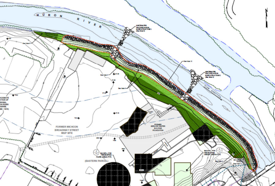
That potential conflict in types of use is one of several factors that Sallee will be weighing in an upcoming decision he’ll be making about issuing a permit to MichCon for construction of a whitewater amenity in the dam-side river channel. It was originally supposed to be part of the city’s Argo Cascades project, but MichCon offered to pay for the whitewater structures, in connection with its environmental cleanup of land on the opposite side of the Huron River, across from the cascades.
The idea is that kayakers will descend through the Argo Cascades, and when entering the Huron River will paddle upstream a short distance to the whitewater feature. One factor that Sallee said he’ll weigh is the potential conflict in recreational use between anglers and boaters.
On July 25, a public hearing was held on the MDEQ permit for the whitewater amenity construction. Sallee told The Chronicle that he expects to make a decision on the issuance of a permit by Sept. 21, or possibly sooner.
The Chronicle could not survive without regular voluntary subscriptions to support our coverage of city of Ann Arbor issues. Click this link for details: Subscribe to The Chronicle. And if you’re already supporting us, please encourage your friends, neighbors and colleagues to help support The Chronicle, too!
This would all be easier to make sense of if there were a gauge on Barton Pond and a gauge on Argo Pond, so that water levels could be reviewed directly and not guessed at.
This is a great article, although it’s still not clear to me why the water level has to bounce around so much, as it continues to do. Also, it would be great to have a map or diagram or something to see how the whitewater scheme (excuse me, amenity) is supposed to work.
Paul,
I’ve added a link in the article to an extract from a schematic provided by MichCon depicting possible locations for the whitewater amenities, and included it here as well: [link]. I believe that since those schematics were drawn, the locations have been moved upstream a bit to reduce potential for Cascades versus Whitewater user conflicts. So take the drawing as illustrating the concept as opposed to the construction drawings or what was included in the permit application.
As for the bouncing around, it’s my understanding that the dam gates don’t have an infinite number of positions to which they can be opened, but instead ratchet between settings that correspond, for example, to 0, 25, 50, 100 and greater cfs. So the coarseness in available control of the gates is reflected in the flow variation.
Hello,
Thanks very much for investigating and writing this very informative article.
I would like to add a few comments.
1. Part of the reason for the recent sawtooth activity is due to the manual operation of both dams.
As you know I have been hanging out near argo dam a lot lately. One day, the dam operator showed up (the guy who actually operates the dam, not a bureaucrat) I got the chance to speak with him at length. He even let me blow the horn. During the period of extreme low flow he was operating both dams manually because the automatic operation was not working. He said they were making adjustments every few hours instead of the normal automatic operation which makes fine adjustments all the time.
2. I do not believe the stop log had any effect on flow rate through the cascades. The stop log probably decreased the cross sectional area of flow but increased the velocity. I am working on a system to actually measure the flow rate through the entrance to the cascades. It should be fairly easy since the cross sectional area is easy to measure when the channel is rectangular.
3. Edward, there is a gauge on both Barton pond and Argo pond. The data is recorded by the dam operators. The data is not available online in real time but is available in print. I have lots of data from past years. I am sure you could get the current data if you asked.
Thanks again for the article.
Hi Dave,
I would like to comment about the dam operation.
I have personally witnessed the operation at Argo Dam and seen the controls.
Each gate at Argo has infinite adjustment. There is a dial that can be set at any position and there is no ratchet. The dial is marked in 10ths of a foot and the operator typically sets the dial at those marks but can set the dials between the marks.
The dam operator indicated to me that the controls at Barton are similar.
Thanks
We have had extreme drought conditions for weeks, hopefully, a rare situation. I suggest we not change too much now until we see what happens the next year.
In my opinion the potential conflict between anglers and whitewater kayakers is completely blown out of proportion by misunderstanding and ignorance. I really hope the State considers this when they make their decision.
There are urban communities all across this country that face dam removal and somehow are able to accommodate whitewater kayakers and fisherman. Neither present environmental problems for streams if improvements are designed and built correctly, and neither group alone will make much of an economic contribution.
Water levels downstream of Argo are showing characteristically wide variations (oscillating between 150 cfs and 20 cfs) and have been doing this mid-day August 31. A link with a graph here: [link]