


Aug. 18, 2014: City Council Meeting Preview
Land use and development is set up to be a dominant theme of the council’s second meeting in August, as it frequently is for many of the council’s meetings. An additional highlight will be initial consideration of a change to the city’s taxicab ordinance – in response to the entry of services like Uber and Lyft into the Ann Arbor market.
A report from the city administrator on options for deer management has led to a resolution on the Aug. 18 agenda appropriating $20,000 for the development of a deer management program.

Screenshot of Legistar – the city of Ann Arbor’s online agenda management system. Image links to the Aug. 18, 2014 meeting agenda.
Among the land use items on the Aug. 18 agenda is one related to use of city-owned land – three parking lots at Fuller Park: (1) the parking lot south of Fuller Road, next to the railroad tracks; (2) the paved parking lot north of Fuller Road at Fuller Park; and (3) the unpaved parking lot north of Fuller Road at Fuller Park. The lots are used by the University of Michigan during restricted hours.
The council will be considering a two-year lease with one additional two-year option for renewal. Annual revenue from this lease will be $78,665, and will be included as part of the parks and recreation general fund budget. The item was forwarded to the city council from the park advisory commission with a recommendation of approval.
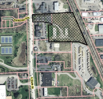
Private land development items on the Aug. 18 agenda include final approval of the rezoning of land for the State Street Village project at 2221-2223 S. State St. The 4.5-acre parcel is proposed to be rezoned from M1 (limited industrial district) to O (office district). Also on the council’s agenda for approval is the site plan for the project that will be made possible by approval of the rezoning – a $10 million development by Ann Arbor-based McKinley Inc. The plan calls for constructing two 4-story apartment buildings at the rear of the site, totaling 112,262 square feet, with 38 units each. Another 2,027-square-foot building – for a leasing office with two apartments above it – would be built on the front of the parcel, on South State.
Also on the agenda for final approval is the rezoning required for an Ann Arbor Housing Commission project – a 4.8-acre site at 701 N. Maple Road. The zoning would change from R1C (single-family dwelling district) to R4B (multi-family dwelling district). The site plan, which is also on the council’s Aug. 18 agenda, calls for demolishing 20 existing single-family homes – the public housing complex known as North Maple Estates – and constructing an eight-building, 42-unit apartment complex with a total of 138 bedrooms. A related item on the agenda is the vacation of a portion of the city’s right-of-way for Seybold Drive.
Rezoning for 121 W. Kingsley Street for a private development is getting initial consideration by the council on Aug. 18. The project calls for rezoning the site from a planned unit development (PUD) to D2 (downtown interface). The development would include renovating the existing two-story, 2,539-square-foot building, plus constructing two additional buildings: (1) a 3.5-story addition to the existing building; and (2) a 4.5-story structure at the southeast corner of West Kingsley and North Ashley. In total, the development would include 22 units and 40,689 square feet. The estimated cost is $6.5 million.
Getting initial consideration by the council at its Aug. 18 meeting are changes to the city’s taxicab ordinance that have been recommended by the city’s taxicab board. The recommendations come in the context of the entry of Uber and Lyft into the Ann Arbor market. The companies offer the arrangement of rides through mobile networks with drivers who operate their own vehicles. Both companies have ignored cease-and-desist orders from the city.
Uber has sent its Ann Arbor customers an email asking them to sign an online petition supporting Uber’s continued ability to operate here.
One ordinance change would establish certain parameters to mitigate possible negative consequences to the setting of a very high maximum allowable taxicab rate, under which taxicab companies might eventually compete. Those parameters include a requirement that a taxicab company commit to a single rate annually and that the rate be advertised in a vehicle with signage in letters one-inch tall. The other ordinance would require that all drivers for hire – whether they are taxicab drivers or drivers who work for Uber or Lyft – register with the city, maintain proper insurance for their vehicles and acquire commercial plates.
In other significant business at its Aug. 18 meeting, the council will also be asked to confirm the re-appointment of Bob Guenzel to the board of the Ann Arbor Downtown Development Authority.
This article includes a more detailed preview of many of these agenda items. More details on other agenda items are available on the city’s online Legistar system. The meeting proceedings can be followed Monday evening live on Channel 16, streamed online by Community Television Network starting at 7 p.m.
Fuller Park Parking Lease
The council will be considering a possible four-year extension on a University of Michigan lease of three parking lots at Fuller Park. The lease comes to the council with a recommendation of approval from the park advisory commission. The commission gave that recommendation at its July 15, 2014 meeting.

Map of parking lots at Fuller Park that are leased to the University of Michigan.
The existing lease expires on Aug. 31, 2014. The three lots are: (1) the parking lot south of Fuller Road, next to the railroad tracks (Lot A); (2) the paved parking lot north of Fuller Road at Fuller Park (Lot B); and (3) the unpaved parking lot north of Fuller Road at Fuller Park (Lot C). The lots are used by UM during restricted hours.
The city has leased Lot A to UM since 1993. Lots B and C have been leased since 2009.
The proposal, which requires city council approval, is for a two-year lease with one additional two-year option for renewal. Annual revenue of this lease will be $78,665, and will be included as part of the parks and recreation general fund budget. [.pdf of proposed lease agreement] [.pdf of staff report]
The hours that UM can use these lots are stipulated in the agreement:
- Lot A: 4 a.m. to 4 p.m. Monday through Friday.
- Lot B (paved lot): 6 a.m. to 5 p.m. Monday through Friday, beginning the day after Labor Day through the Friday before Memorial Day, excluding holidays.
- Lot C (unpaved lot): 6 a.m. to 5 p.m. Monday through Friday, excluding holidays.
At the PAC meeting when the lease was recommended, parks and recreation manager Colin Smith noted that the revenue from these three lots is significant for the parks and recreation operating budget. The current agreement – which was approved by the council in 2009 and extended by two administrative renewals – is essentially the same as the agreement that will expire, Smith told PAC.
The main purpose of the lots is for the parks, Smith explained. That’s reflected in the hours when UM can use the lots – on weekdays, prior to 4-5 p.m. The outdoor pool and soccer fields don’t need the quantity of parking during the winter or off-season. “It’s an asset within the parks department that we can either have sit there, or we can lease it for a significant amount of revenue that obviously helps us provide other programs,” he said. If the city doesn’t lease those parking lots, “I am absolutely certain that people will park in it anyway,” Smith added.
State Street Village
On Aug. 18, the council will consider final approval of the rezoning of land for the State Street Village project at 2221-2223 S. State St. The 4.5-acre parcel is proposed to be rezoned from M1 (limited industrial district) to O (office district). Also on the council’s agenda for approval is the site plan for the project that will be made possible by approval of the rezoning – a $10 million development by Ann Arbor-based McKinley Inc. The plan calls for constructing two 4-story apartment buildings at the rear of the site, totaling 112,262 square feet, with 38 units each. Another 2,027 square foot building – for a leasing office with two apartments above it – would be built on the front of the parcel, on South State.
Aerial view of State Street Village site.
Action on the initial approval came at the city council’s July 21, 2014 meeting. A recommendation for the rezoning was given at the June 17, 2014 meeting of the Ann Arbor planning commission.
At that meeting, commissioners recommended approval of the site plan, development agreement and rezoning for the project.
The front part of the site is currently a surface parking lot, and is zoned O (office). The rear parcel – 4.5 acres – is vacant, and zoned M1 (limited industrial). Residential developments are permitted in office-zoned areas. [.pdf of staff report]
The development will include 114 parking spaces in the rear of the site and 13 spaces for the front. Another 22 spaces in the surface parking lot will be shared by the existing office building just south of the site.
In addition, 44 covered bicycle spaces and 8 enclosed bicycle spaces will be provided near the entrances of the apartment buildings and 2 hoops will be placed near the entrance of the rental office building.
Instead of making a $48,360 requested donation to the city for parks, McKinley has proposed two 8×10-foot grilling patios with picnic tables and grills.
According to the staff memo, the footing drains of 18 homes, or flow equivalent to 71.91 gallons per minute, will need to be disconnected from the city’s sanitary sewer system to mitigate flow from this proposed development.
North Maple Road
To be considered for final approval by the council at its Aug. 18 meeting is the rezoning required for an Ann Arbor Housing Commission project – a 4.8-acre site at 701 N. Maple Road. The zoning would change from R1C (single-family dwelling district) to R4B (multi-family dwelling district). The site plan, which is also on the council’s Aug. 18 has been shifted to the Sept. 2 agenda, calls for demolishing 20 existing single-family homes – the public housing complex known as North Maple Estates – and constructing an eight-building, 42-unit apartment complex with a total of 138 bedrooms. A related item on the agenda is the vacation of a portion of the city’s right-of-way for Seybold Drive.
The Ann Arbor planning commission recommended all three items for approval at its June 17, 2014 meeting. The council gave initial approval of the rezoning at its July 7, 2014 meeting.
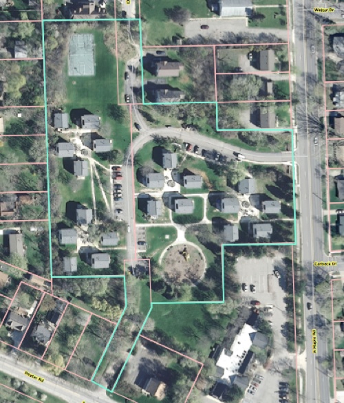
Aerial view of North Maple Estates site, outlined in green.
The project is part of a major renovation effort by the Ann Arbor Housing Commission of several of its properties. The site is on the west side of North Maple, between Dexter Avenue and Hollywood Drive. [.pdf of staff report]
The units in the eight-building, 42-unit apartment complex are proposed to have a total of 138 bedrooms. The units range in size from one bedroom to five bedrooms.
The project would include a playground, community building and 73 parking spaces. According to a staff memo, the buildings would be located along a T-shaped driveway that connects to North Maple Road and Dexter Avenue. The drive extends northward toward Vine Court but does not connect with that street. There would be a new connection to Dexter Avenue through the remaining, undeveloped length of Seybold Drive.
The project also requires the city to vacate a portion of the right-of-way for Seybold Drive. The surrounding land is owned by the housing commission, so if the right-of-way vacation is approved, the land would become part of the housing commission property. In a separate vote, the planning commission also recommended approving that request.
When the project was in front of the planning commission, planning staff noted three issues that need to be resolved before the project gets approval from city council:
The parcel containing two duplex buildings also owned by the Ann Arbor Housing Commission in the northeast corner of the site must be combined with the subject site, forming a single parcel as a requirement for issuance of any permits.
The legal description and comparison chart data must be confirmed to include the duplex parcel.
The northern-most parking stall, nearest the connection to Vine Court, must be relocated outside of the minimum front setback area.
According to the staff memo, after June 3 the city’s traffic engineer reviewed the proposed new connection from Seybold Drive onto Dexter Avenue, and concluded that sight distances from all approaches are acceptable. He suggested that the pavement markings on Dexter should be refreshed.
The reconstruction of North Maple Estates is part of an ongoing effort by the housing commission to upgrade the city’s housing stock for low-income residents. At the planning commission’s May 6, 2014 meeting, AAHC executive director Jennifer Hall had made a presentation about the initiative, which includes seeking private investors through low-income housing tax credits.
121 Kingsley West
Rezoning for 121 W. Kingsley Street for a proposed new development is getting initial consideration by the council on Aug. 18. The project calls for rezoning the site from a planned unit development (PUD) to D2 (downtown interface). The development would include renovating the existing two-story, 2,539-square-foot building, plus constructing two additional buildings: (1) a 3.5-story addition to the existing building; and (2) a 4.5-story structure at the southeast corner of West Kingsley and North Ashley. In total, the development would include 22 units and 40,689 square feet. The estimated cost is $6.5 million.
The rezoning will be on the council’s agenda, but the site plan will not come before the council until the zoning is considered for a second and final vote. The Ann Arbor planning commission’s recommendation of approval for the site plan and the rezoning came at its July 15, 2014 meeting.
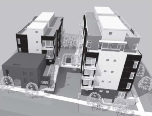
Rendering of 121 Kingsley West project, looking south from Kingsley. The existing building is in the left foreground.
Developers are Tom Fitzsimmons, Peter Allen and Mark Berg. The architect is Marc Rueter.
There would be 29 parking spaces below the buildings – though only two spaces are required, based on residential premiums that the project is seeking. The premiums give the project additional floor area, compare to what’s allowed by right. An elevator for each building will be accessible from the parking level. The parking level of the east building will include a bike room with 14 spaces.
According to a staff report, the project’s development agreement will address “easements for encroachments onto the City right of way by the existing building, onsite stormwater management, verification of LEED points, six required footing drain disconnects, future façade alterations, and the contribution to Parks and Recreation Services.” [.pdf of staff report]
Planning commissioners unanimously recommended approval of the rezoning, site plan and development agreement. However, only five commissioners on the nine-member body were present, and the commission’s bylaws stipulate that approval requires six votes. So the project was forwarded to city council for consideration with a recommendation of denial from the commission. Wendy Woods, the commission’s chair, assured the developers that city council would be informed that the project secured unanimous support from all commissioners who were present.
The project is on the same site as a previously proposed project by Peter Allen called Kingsley Lane. That had been envisioned as a larger development with 46 units in a complex with two “towers” – at four and nine stories. According to a 2006 Ann Arbor News article, pre-sales of the units were slower than expected because of the struggling housing market, and ultimately financing fell through. At a July 9, 2013 planning commission work session, planning manager Wendy Rampson reported that the developers had lost the property to the bank, but subsequently secured the land and were expected to submit a new site plan.
Taxicab Ordinances
Getting initial consideration by the council on Aug. 18 are two changes to the city’s taxicab ordinance that have been recommended by the city’s taxicab board. The recommendations come in the context of the entry of Uber and Lyft into the Ann Arbor market. The companies offer the arrangement of rides through mobile networks with drivers who operate their own vehicles. Both companies have continued to operate in Ann Arbor, despite cease-and-desist orders from the city. [.pdf of cease-and-desist sent to Lyft] [.pdf of cease-and-desist sent to Uber]
The vote to recommend the ordinance changes came at the July 24, 2014 meeting of the taxicab board.
These issues were also discussed at three monthly meetings of the taxicab board prior to that, on April 23, 2014, May 22, 2014 and June 26, 2014.
One ordinance change would establish certain parameters to mitigate possible negative consequences to the setting of a very high maximum allowable taxicab rate, under which taxicab companies might eventually compete. Those parameters include a requirement that a taxicab company commit to a single rate annually and that the rate be advertised in a vehicle with signage in letters one-inch tall.
The current structure for fare regulation already allows for the adoption of a maximum rate to be adopted by the city council. Currently the maximum rate in Ann Arbor is $3 to get in, $2.50 per mile, and 40 cents per minute waiting time. Those maximum rates were last adjusted upwards three years ago, on May 16, 2011, in response to gas prices that had nudged past $4 per gallon. At that time, the taxicab board indicated it did not anticipate considering another rate change until the gas prices were over $5 for at least two consecutive months.
So the taxicab board’s thinking is not being driven by gas prices, which are currently between $3.75 and $4 in the Ann Arbor area. Instead, a possible increase in allowable fares is based on concern that the taxicab industry in Ann Arbor might not be able to survive unless taxis are allowed to charge more.
At its July 24 meeting, taxicab board members discussed the possibility of delaying their recommendation on the ordinance changes until the board could also make a specific recommendation on the price point for a very high maximum rate. But ultimately board members felt that a recommendation on a price point for a new maximum rate could come later – especially because ordinance changes require a first and second reading in front of the council. There would be a window of opportunity between those readings to make a recommendation on the higher maximum. The taxicab board’s next meeting is scheduled for Aug. 28 at 8:30 a.m. at city hall.
The other ordinance change to be given initial consideration would require that all drivers for hire – whether they are taxicab drivers or drivers who work for Uber or Lyft – register with the city, maintain proper insurance for their vehicles and acquire commercial plates. Commercial plates would require that the commensurate commercial insurance is carried.
And the absence of commercial plates on a vehicle that is observed to be used for picking up or dropping off passengers would provide a primary reason for a traffic stop by Ann Arbor police. At the taxicab board meetings over the last few months, representatives of the taxicab industry argued that the state statute regulating limousines already gives the city the ability to enforce against Uber and Lyft drivers.
Deer Management
Attached to the Aug. 18 city council agenda is a report from the city administrator outlining issues and options for management of the urban deer herd in Ann Arbor. Based on that report is a resolution, sponsored by Sabra Briere (Ward 1) and Jane Lumm (Ward 2), that would accept the report and appropriate $20,000 from the general fund for development of a “community endorsed deer management plan.” [.pdf of Aug. 14, 2014 deer management options report]
The council had directed the preparation of the report on various options in a resolution approved at its May 5, 2014 meeting. The report was to have been delivered to the council by July 31.
Fall 2015 is the earliest date identified in the report as a possible timeframe for a culling of the herd.
Before developing a specific plan – that could involve killing deer or not – input from Washtenaw County Parks and Recreation and the University of Michigan would be sought. And the Michigan Department of Natural Resources would need to approve any plan for deer management. The Aug. 14 report includes descriptions of deer management plans in other Michigan cities that range from ordinances prohibiting the feeding of deer to culling programs that shut down city parks and prescribe shooting lanes for archers.
City of Ann Arbor staff estimate that six months would be needed for public engagement. That public engagement could start within 45 days of city council approval to proceed.
Estimated staff time to develop the specific plan is 160 hours, according to the Aug. 14 report. Contractual public engagement and support to develop a management plan are estimated at $20,000.
Other facts included in the plan are the fact that neither city parks nor golf courses have had vegetation damage by deer. The cost to the city for disposing of deer carcasses in fiscal year 2014 was $5,850.
Estimated cost to kill 40-50 deer in the city of Ann Arbor is $25,000-$27,000 per year. That amount includes city staff administration cost in the amount of $14,000.
All deer-car accidents in Washtenaw County from 2004 through 2013 are plotted in the dynamic map below. Map is by The Chronicle with data from michigantrafficcrashfacts.org
Based on the map of deer collisions, this seems like a job for Pacman.
Looking at the map, it’s clear to me that no matter what the city does, there will be lots and lots of deer around. Better to educate residents about what NOT to plant, how to react if a deer jumps in front of a car or bike, and enact a fine for feeding deer. Otherwise, it seems like a huge, never-ending waste of money.
That map tells it all. Consider how many accidents are not on that map each year – I have had two deer/vehicle collisions in that time frame that went unreported. What’s to report? Very little vehicle damage to a work truck, one dead deer, and one deer that ran off, whereabouts unknown. Every time one of my hunting friends sees a deer dead by the side of the road, he says “That’s why I hunt, there are too many deer.” We live in a county that is depending on your point of view blessed with or cursed by an abundance of natural fauna. For a great history of DNA Deer Management practices read this [link], which includes this choice quote: “Deer management has also taught us that the hardest species to include in ecosystem management is Homo sapiens.”
Ha! I am sure the “deer menace” has more to do with us encroaching on their natural habitat, allowing apartment buildings and subdivisions to be built on once natural spaces. All of a sudden we have a deer problem? Hey, let’s spend some $ to study the problem…
As for offering solutions, according to this exhaustive report, it looks like our region takes a lot of deer, but the densely populated SE Region – the counties to our east, have the fewest deer taken through legal means, not just per capita, but in total, with the exception of the sparsely populated Eastern Upper Peninsula region.
[link]
Basically, we can’t take enough deer in this area to thin the herds. Statewide, and in our region, the harvest is up, but the SE Region is down. This report needs a proper going over, Chronicle Style, to determine if a change in allowed permits would make a difference, but I don’t think it will, we did not use all of the 1500 public land licenses assigned to Washtenaw County in 2012, nor did we use all of the private land permits allowed in the region. The overlapping regions make it difficult to determine what happened where, but it looks like in SE/S Central Lower Michigan we don’t hunt enough to maintain balance with our growing human population. I think this “deer problem” calls for an examination not of our deer control practices, but of our land use practices.
@2: I agree, Karen. We don’t need to spend money on a management plan, just start with the obvious step of prohibiting the intentional feeding of deer. Some council member will likely raise concerns about the cost of enforcement, but enforcement of such regulations is always secondary to the public awareness aspect of such efforts and wouldn’t amount to much expense. Absent artificially abundant food supplies, most deer would likely head back to areas outside the city where there are a lower concentration dogs.
The City Attorney does not have the authority to issue “orders” to firms like Uber and Lyft. Only judges can issue orders that would be binding on these companies. We could make do with a little less posturing from the City Attorney.
I’ve mapped out some of the data in the report that Jeff Hayner cites. [2012 data on deer taken] [map] [For Lower Peninsula only. Generally, the DNR's "Deer Management Units" correspond to counties. But in three instances in the Lower Peninsula, there's not a 1-1 correspondence. So I've parceled out the DNR numbers to their corresponding counties, in one case arbitrarily assigning 25% of the DMU numbers to each of the four counties overlapped by the DMU.]
Here is the website of the group who are promoting a deer management plan. http://wc4eb.org/ Their name is Washtenaw Citizens for Ecological Balance.
Wow thanks Dave – as you saw in the report the DMU overlays allow increased harvest, but Washtenaw County looks like it does it’s fair share of deer hunting even without this. I don’t think this “deer problem” is going to be solved by increasing the harvest. This “deer problem” is a people problem. Hopefully there will be a broad conversation at council about the role human population growth and land use in Washtenaw County play in this. It’s only going to get worse as we continue to allow development of natural areas, no matter how low-quality they seem to us; to wit: Nixon Road/Toll Brothers, Northfield Township/Biltmore, north Pontiac Trail. Heck, the new Traverwood Apartments construction has already displaced a herd; I have photos of a herd walking across the initial grading and site work near “Peeper Pond” at dusk a few months back.
The roaming habits of deer are simple to understand. Want to see deer in the City? Go to an open body of water at dawn or dusk. Why so many accidents on Whitmore Lake Road? The deer are crossing from the water on the west to bed down in the field margins on the east, at dusk. Same goes for Huron Parkway, or Green, even Barton Drive has active deer crossing in the evening, running along the river bank. It is a genetic memory at work here, a natural lifestyle we have disrupted with our development. We simply don’t value natural areas in the city, the greenbelt acquisition has been paltry, and all land “inside the ring” seems to be fair game for dense development, with no consideration given to the benefits of the natural state or agricultural value of the land. Got deer? Too bad.
It has been pointed out by my wife that “Too Bad” does not convey the right sentiment. What I really mean to say is, “Why should we all be asked to pay for the resolution of this problem, if our other concerns about land use and contributing causes continue to go unheard?”
About deer. The council’s previous direction to the city administrator to deliver a report on various options for deer management – followed by the delivery of that report, plus the broad political support that some type of action enjoys (e.g., Washtenaw County commissioners) – could be fairly analyzed as the city council taking action in a measured, moderate step-wise fashion.
So it’s now an “easy” vote to appropriate $20,000 to develop a plan – a plan that the resolution on Monday’s agenda indicates is supposed to be endorsed by the community. It’s an “easy” vote in favor – because: (i) it’s only the creation of a plan, which will require additional city council approval; and (ii) the plan will be community-endorsed.
That punts the actual controversy down the road – which will come when the council is asked to approve the deer management plan.
The council’s approach to this problem, while measured and stepwise, is not – in my view – informed by some basics of public policy consideration. Recall that the city council, at its December 2012 retreat, seemed really receptive to the facilitator’s general advice on public policy issues, which was to think about two key questions: (1) What is a clear statement of the problem? and (2) What does success look like?
I think it goes without saying that the deer management plan – like any kind of public policy proposal – should be “community-endorsed.” But surely having and implementing a community-endorsed deer management plan is not an adequate answer to the question: What does success look like?
The council should be directing the city staff to develop a deer management plan that is designed to achieve success. But what does that mean? It’s the city council’s job as a policy-making body to define success. But the Aug. 14 report on options does not really provide enough information to define a metric for success. I don’t think it’s a deficiency of the report, but a deficiency on the council’s part in directing the creation of the report.
Some ideas for answering that basic question can be gleaned from the report. But at this stage we should have more than just some ideas for possibilities about what kind of success a deer management program is supposed to achieve.
Before spending $20,000 on the development of a plan, the council should be able to answer the following types of questions. What is the geographic scope of our definition of success – city, county, region? Is success defined in terms of number of deer-vehicle accidents, complaints from residents about damage to gardens and landscaping, damage to public property, or simply the number of deer within the geographic scope? If success is defined in terms of the measured deer population, what is that number? [E.g., From the Aug. 14 report: "City of Jackson have a deer population density goal of 15 deer per square mile."]
The Aug. 14 report estimates the cost of a program that would take 40-50 deer at about $25,000. The Michigan DNR report cited above indicates that in 2012 there were about 6,600 deer taken in Washtenaw County. I’m somewhat skeptical increasing the local deer harvest by less than 1% is going to have a meaningful impact on some metric of success – regardless of how it is defined. But I’m certainly open to being proven dramatically wrong. That proof would, however, require a clear answer to the question: What does success look like?
Dave, success looks like less deer-car crashes; you did your map, it’s clear that it’s a map of failures.
Success might also mean tasty venison stocking the larders at Food Gatherers.
Ed, my criticism is not that “nobody has said anything about what they think success looks like.” It’s that the council has not done so. If fewer deer-car crashes is what success looks like, that implicates that a statement of the problem includes something like: “There are too many deer-car crashes.” Fine. So what is the geographic scope of that statement? And what would be a number that is not “too many”? Or do we implement a deer extermination program and keep killing some every year, no matter what?
Assuming those questions can be answered, it’s not obvious that the most efficient way to reduce deer-car collisions is to cull the deer herd. Looking at the map, the density of deer collisions inside the city is exactly where you might predict – along high-traffic arteries in close proximity to large natural/open areas: Plymouth, Huron Parkway, Glazier, Fuller. If our goal is to reduce deer-car accidents, then the first thing I would think to ask is: Do we have any deer-crossing signs along those corridors?
To answer that question, I took a spin this morning up Plymouth to Huron Parkway, south on Huron Parkway to Washtenaw, back up Huron Parkway to Glazier, and took Glazier and Fuller back into town. I counted one such sign – at Hubbard & Huron Parkway. That one sign was very close to the gateway sign for the University of Michigan North Campus – so I think it might actually be placed on UM property. It’s entirely possible I missed some signs – as my eyes are old, my mind tends to drift as I pedal along, and it was before morning coffee. (I spotted two yellow-diamond golf-cart crossing signs, which I initially mistook for deer-crossing signs…those clubs seemed like they could be antlers.) More seriously, it might be the case that there are warrants that have to be met before placing such signs, and it’s just not possible to place those signs within the city. (Inquiry made.)
If the council can’t manage to come up with a clear statement of what success looks like, and commit to that statement in its resolution that allocates $20,000 to develop a plan, then their action will be tantamount to saying,”Success looks like: Looking like we’re doing something.”
As a follow-up to the deer crossing signage question, I inquired with city traffic engineer Les Sipowski about the conditions under which the city can place deer crossing signs.
From Sipowski’s reply email:
So it sounds like we have two such signs citywide. (I didn’t include Dhu-Varren in this morning’s survey.)
It looks like you could start a new business called “Chronicle Consulting” which produces $20,000 reports for the city of Ann Arbor, the DDA, the Ann Arbor Public Schools and more. It would be so much more efficient. And, the reports would be top notch.
I can probably document more than $20,000 in damage to property and vehicles that happened this past year.
Along with creating a regulation prohibiting the feeding of deer, lets revoke the dogs on leash requirement– and give us a chance!