Ideas Floated for South State Corridor
An informal session with University of Michigan urban planning students gave Ann Arbor planning commissioners more ideas for possible changes to the South State Street corridor.

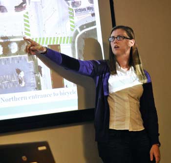
Danielle Thoe, a University of Michigan graduate student in urban planning, explains a concept for creating a boulevard for pedestrians and bicyclists to navigate better the I-94 overpass along South State Street. (Photos by the writer.)
The Nov. 27 meeting included a presentation by four graduate students in urban and regional planning. They had analyzed the corridor between Ellsworth and Stimson, which the city has also been studying. The presentation came in the context of a draft report currently under review by planning commissioners, with more than 40 recommendations to improve the corridor. [.pdf of draft report]
The students approached their work by identifying changes that could have an immediate impact on the corridor, while also looking at more visionary, long-term goals. Shorter-term suggestions included replacing and widening sidewalks, and adding new sidewalks in sections where there are none.
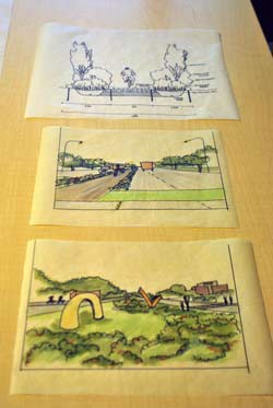
A more ambitious idea is to transform the broad center turn lanes on the I-94 overpass into a protected bicycle/pedestrian median. Currently, navigating the freeway interchange on foot or by bike is daunting. The approach could serve multiple purposes. If bioswales and landscaping were in place along the outer edges, it would help with stormwater management and provide a physical barrier between vehicles and pedestrians/cyclists. The greenery would also have visual impact for people exiting the freeway, indicating that you’re entering a city that values the environment and alternative transportation, according to the students.
Creating a sense of identity along the corridor was a common theme, with an additional focus on safety issues, stormwater management, and functionality/aesthetics.
The meeting was attended by four of the eight current planning commissioners, as well as planning manager Wendy Rampson. The commission is expected to make a recommendation on the city’s draft corridor plan at either its Dec. 18 or Jan. 3 meeting. The Ann Arbor city council would need to approve the plan before any action is taken toward implementing its recommendations.
State Street Background: Ongoing Study
The city planning commission and staff have been discussing improvements on South State for years. It was brought up more than two years ago at the commission’s April 2010 retreat, as one of the priorities that the body hoped to address as part of a broader effort to look at all of the city’s major gateway corridors, including Washtenaw Avenue to the east, Plymouth Road to the northeast, and North Main Street.
A year later, at an April 2011 work session, planning commissioners and staff talked about issuing a request for proposals (RFP) for a consultant to take on the work. About $150,000 had been set aside for a consultant’s study. But when the project moved to the city council for approval, a majority of councilmembers at that time were reluctant to make the expenditure, and the funding was not approved.
Planning staff took on the task instead, and planning commissioners were briefed on progress at an October 2011 work session. The work included interviews with businesses, residents and other stakeholders, public forums, and online feedback through the A2 Open City Hall site. For more detailed background, see Chronicle coverage: “South State Corridor Gets Closer Look.”
The area of study has focused on a roughly 2-mile stretch between Stimson Street at the north end down to Ellsworth in the south, and includes: a major intersection with I-94; Briarwood Mall; the large Hidden Valley Club apartment complex; acres of land owned by the University of Michigan, including its golf course and a sports complex; large office buildings, including 777 Eisenhower and UM’s Wolverine Tower; several hotels near Victors Way and Broadway; and a research park development near the corridor’s south end.
A draft report – including more than 40 overall recommendations for improving the corridor – was presented to commissioners at their Sept. 18, 2012 meeting. [.pdf of draft report]
Recommendations in that report are organized into categories of the city’s recently adopted sustainability framework: Land use and access, community, climate and energy, and resource management. Among the recommendations are: (1) Evaluate use of vacant parcels for alternative energy generation; (2) Evaluate integrating public art along the corridor; (3) Evaluate use of open land for community gardens; (4) Assess and improve high crash areas along the corridor; (5) create boulevard on State Street between Eisenhower and I‐94 to enable safer automobile, bicycle, and pedestrian movement; (6) Consider utilizing vacant parcels for athletic fields and recreation facilities; (7) Develop a pedestrian and bicycle path along the Ann Arbor railroad that will connect the planned Allen Creek bikeway to Pittsfield Township through the corridor; and (8) Resurface roads in the corridor.
Each recommendation includes several related action items. The report also provides a section that organizes the recommendations into each of three distinct sections of the corridor: (1) from Stimson on the north to Eisenhower Parkway; (2) from Eisenhower south to the I-94 interchange; and (3) from I-94 to Ellsworth.
UM Urban Planning Charrette
On Nov. 27, four University of Michigan graduate students in urban planning met with planning commissioners and staff to present ideas for transforming the South State corridor. Christian Roadman, Katy Ryan, Liz Treutel and Danielle Thoe – studying for master of urban planning degrees at UM’s Taubman College of Architecture & Urban Planning – spent about an hour explaining their proposals and talking to commissioners about the area.
Christian Roadman began the presentation by saying the group tried to strike a balance between identifying low-hanging fruit that would have an immediate impact on the corridor, while also looking at more visionary, long-term goals. Their suggestions primarily focused on safety, stormwater management, and functional aesthetics – not beauty for beauty’s sake, he said, but rather how to incorporate public art into functional things like signs or fences.
Overall, the students felt that the corridor lacked a sense of place, Roadman said. They wanted to develop that sense of place immediately when people enter the corridor off of I-94, and from there to build a feeling that “I’m coming into a unique city.”
Danielle Thoe highlighted the existing sidewalks, which she described as dilapidated and “disappearing.” In some stretches, there are no sidewalks at all, and in many spots they are narrow and very near the street, close to fast-moving vehicles. She noted that one easy solution would simply be to install new sidewalks, which would make pedestrians feel safer and make it viable to walk down the street.
Creating wider sidewalks would also be a benefit, Thoe said. Although there are bike lanes along parts of South State, the motorized vehicles travel fast and don’t always respect those bike lanes. Nor are the bike lanes welcoming for all types of bicyclists, she noted. It’s not likely a family would feel safe riding bikes along South State to the mall or restaurants there. Widening sidewalks would address this by creating multi-use paths for pedestrians, runners and cyclists.
Continuing south, Thoe pointed out that the intersection of I-94 creates an even greater problem for pedestrians and bicyclists trying to safely navigate across the bridge through heavy traffic and turning vehicles. The UM students suggested transforming the broad center turn lanes into a protected bicycle/pedestrian median over the freeway. Wide green stripes could be painted on the streets to indicate a crossing that would lead to the median.
Katy Ryan told commissioners that such an approach could serve multiple purposes. If bioswales and landscaping were in place along the outer edges, it would help with stormwater management and provide a physical barrier between vehicles and pedestrians/cyclists. The greenery would also have visual impact for people exiting the freeway, indicating that you’re entering a city that values the environment and alternative transportation. After going over the I-94 interchange via this center path, the cyclists and pedestrians would cross back into regular bike lanes and sidewalks on the other side.
Liz Treutel then highlighted other medians along South State, which are concrete but poorly maintained, with weeds growing through cracks. The suggestion is to change those medians into functional spaces for stormwater management with native plantings, and perhaps incorporate public art there as well. Vegetation in the center medians would make the road seem narrower and more inviting.
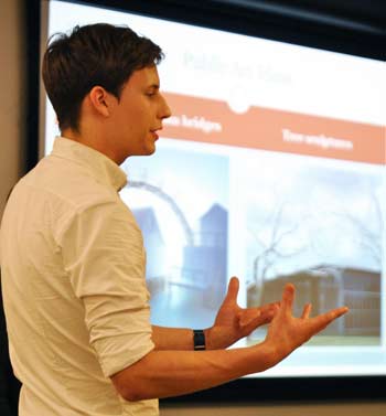
Treutel described some ideas for public art, with the goal of providing a cohesive identity for the entire corridor. Artwork displays could be changed biannually or quarterly, to bring change and excitement to the area. Public art could be incorporated into bus stops, signs and fences, such as the one along the UM golf course at the corridor’s north end. Other examples include a pedestrian bridge that could be designed in a creative way, or having a community contest to create different kinds of Ann Arbor wolverine sculptures, akin to the fiberglass cows exhibits in New York, Chicago and other cities. Also mentioned were tree sculptures, like the metal works designed by the artist Roxy Paine. [There is precedent for metal tree sculptures in Ann Arbor – as two are installed in West Park, funded by the city's Percent for Art program.]
The goals for the corridor should be to increase development with the goal of placemaking, Thoe said – reflecting the identity of Ann Arbor. Longer term, changes in zoning code could encourage a reduction in setbacks, with new buildings constructed closer to the street and parking in the rear. Ultimately, the hope is to create a true corridor, she added, that draws and guides people into the city while simultaneously introducing them to the city’s values and culture.
To describe why change is needed, Roadman described his own experience on his first trip to Ann Arbor. He traveled here on the Megabus, and disembarked at a South State Street park-and-ride lot. There was no sense of being in a special place – the location and first impression didn’t get him as excited about the city as it potentially might have, he said.
Thoe listed some possible next steps, prioritized by the ease of implementation – from installing sidewalks and bike/pedestrian paths to road resurfacing, zoning changes, and development of a bus rapid transit (BRT) system.
Ryan wrapped up the presentation by saying they had a great time with the project, and became really invested in the ideas.
UM Urban Planning Charrette: Commission Discussion
Planning manager Wendy Rampson asked about the issue of identity. When the students talked about Ann Arbor’s identity, did they mean the city or the University of Michigan? Danielle Thoe replied that they hadn’t been envisioning a UM-centric identity, but certainly the university would be part of it, especially since UM owned so much property along the corridor. Thoe described the city’s identity as intellectual and innovative – a place where people would want to stay, whether or not they had attended UM.
Planning commissioner Bonnie Bona said she sensed that the students had been a little restrained in their approach. She encouraged them to push their ideas even further. For example, she suggested putting in a center-lane pedestrian/cycling boulevard along the entire stretch, from the planned roundabout at State and Ellsworth all the way north, perhaps to another roundabout that would bookend the corridor at Stimson.
Katy Ryan replied that they were concerned about presenting ideas that might seem too much like a pipe dream.
Commissioner Ken Clein mentioned the idea of having a version of New York City’s High Line, an elevated park. Christian Roadman said the students had talked about the need to improve bus routes. He liked the notion of vertical integration, like creating an elevated pedestrian/cycling path built over a lane dedicated to bus rapid transit. Rampson observed that traffic engineers can come up with some innovative ideas, if they’re prompted to think creatively.
Rampson liked the idea of viewing the medians as pallets for other purposes, like rain gardens and public art. She also said she was fascinated by the idea of sculptural signage. David Diephuis, a resident who attended the session, floated the idea of using large sculptures to evoke specific destinations, like a huge bed to point the way to hotels along the corridor.
There was some discussion of using tree sculptures to create a canopy along a central pedestrian/bike median. That prompted Diephuis to look up the Roxy Paine sculptures on his iPad – he noted that they cost a minimum of $1 million each. Jennifer Olmstead, the Taubman College’s career services and alumni network coordinator who had facilitated this project, wondered whether Briarwood Mall might view the idea as a branding opportunity – with trees emphasizing Briarwood.
Clein joked about a tie-in with local history. Harry Bennett, the head of security for Henry Ford, lived in the Ann Arbor area along the Huron River, in an estate called Bennett’s Castle. Bennett built realistic-looking concrete trees that were designed so that his gunmen could stand inside the trunk and shoot through slots, Clein said. So there’s precedent, he said, adding “not that we should have any shooting.”
Referring to sculptures and other possible artwork, Roadman observed that there’s a fine line between just putting something there for art’s sake, versus using artwork to create a cohesive sense of identity.
Clein noted that the city has been struggling with the identity of South State for a long time. Many people see it as just a drive-through area between destinations, but clearly there are a lot of people who view it as more than that, he said. The ideas presented by the students have addressed this issue, bringing in the concepts of sustainability and the “tree town” reputation of Ann Arbor. The ideas have real viability, he said.
Next Steps
The city’s draft South State corridor report is being reviewed by planning commissioners, who are expected to vote on it at their Dec. 18 or Jan. 3 meeting. Their recommendation would be sent to the Ann Arbor city council, who would be asked to authorize the plan formally to be distributed to adjoining jurisdictions – including Pittsfield Township, which the corridor abuts.
At that point, there would be a formal 42-day comment period before the plan’s formal approval process. The city would hold another public meeting on the plan during that 42-day period, according to planning manager Wendy Rampson.
When the plan is approved, city staff would begin identifying ways to implement the recommended actions, including identifying funding sources.
Next regular meeting: Tuesday, Dec. 4, 2012 at 7 p.m. in the second-floor council chambers at city hall, 301 E. Huron St., Ann Arbor. [Check Chronicle event listings to confirm date]
The Chronicle survives in part through regular voluntary subscriptions to support our coverage of publicly-funded entities like the city’s planning commission. If you’re already supporting The Chronicle, please encourage your friends, neighbors and coworkers to do the same. Click this link for details: Subscribe to The Chronicle.


Good to see the U-M students giving their learned input!
This is great. I wish they could take on the North Man corridor between Depot and M-14!