New Residential Project Moves to Council
Ann Arbor planning commission meeting (March 19, 2013): Planning commissioners reviewed two projects at their most recent meeting: a commercial project near South State and Ellsworth; and a residential development off Traver Road near the Leslie Park golf course.
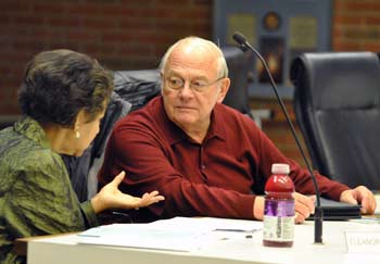
Ann Arbor planning commissioners Eleanore Adenekan and Tony Derezinski at the commission’s March 19, 2013 meeting. (Photos by the writer.)
The commission discussed, but then postponed action on a proposed site plan for State Street Center, just north of Ellsworth near the new Tim Hortons. The project calls for a drive-thru restaurant and separate retail building, with an entrance off of South State.
The planning staff had recommended postponement after discovering that the city’s official zoning map had been incorrectly labeled. It showed the site as zoned C3 (fringe commercial), and the developer had made plans based on that erroneous labeling. But during background research for this proposal, planning staff discovered that the site actually had been zoned as O (office) in 2003. The postponement is intended to allow the developer to submit a rezoning request.
A project that had previously been postponed by commissioners – called Hideaway Lane – was discussed and ultimately recommended for approval on March 19. The proposal is a residential development of 19 single-family houses on a 4.6-acre site off Traver Road, near the city’s Leslie Park golf course and on the edge of Traver Creek. Much of the discussion focused on issues related to the project’s impact on natural features, and how the developer plans to mitigate that impact.
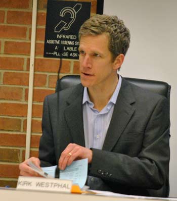
The commission also authorized the reimbursement of expenses for Kirk Westphal – the commission’s chair – to attend the American Planning Association’s National Planning Conference in Chicago from April 13-17. He’ll appear on a panel with city staff to talk about Ann Arbor’s recently adopted sustainability framework. Westphal, a Democrat, recently announced his intent to run for Ann Arbor city council in Ward 2, for the seat currently held by Jane Lumm.
Hideaway Lane
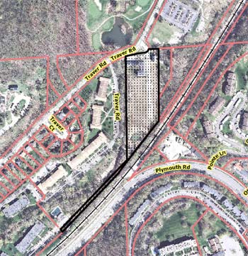
A proposal to build 19 single-family houses on a 4.6-acre site on Hideaway Lane off Traver Road – near the city’s Leslie Park golf course – was on the planning commission’s March 19 meeting.
Action on the planned project’s site plan and development agreement had been postponed at the commission’s Feb. 5, 2013 meeting. At that time, the city’s planning staff had cited the need to resolve several outstanding issues, such as determining the project’s impact on the property’s natural feature and mitigation requirements. Traver Creek runs along the site’s western border.
Also needed was preliminary approval from the Washtenaw County water resources commissioner. On Feb. 5 the vote to postpone was 5-3, with dissent from Bonnie Bona, Kirk Westphal and Diane Giannola. The item came up late in the Feb. 5 meeting – after 11 p.m., following a long discussion and public hearing on the controversial 413 E. Huron project.
At the commission’s March 19 meeting, the recommendation from city planning staff was to approve the project’s site plan and development agreement. In separate resolutions, commissioners were also asked to: (1) authorize the project’s anticipated disturbance of the natural features open space, and (2) recommend approval of an alternative mitigation plan for the site.
The project is located on the site of two developments that were never completed. An original project, approved in 1965, was called Traver Park. It called for six townhome buildings with a total of 49 units. However, only one townhome building, with nine units, was completed.
The next effort began in 2005. That second proposed development – also called Hideaway Lane – moved forward with site grading and infrastructure for four duplexes and 18 single-family homes. But only one single-family home was built before the project stalled due to market conditions and a flagging economy. The site plan for that development has expired.
So currently, the site includes one building with nine townhomes, one single-family home, as well as infrastructure for additional development. The site is zoned R4A (multi-family dwelling district). The proposed new homes would all be two stories tall with either two or three bedrooms. The planned project proposal calls for spacing the houses 10 feet apart. Because the city’s zoning ordinance requires a minimum building spacing of 20 feet, the spacing modifications allowed under a planned project are being requested.
The previous project that was approved in 2005 had included planting the equivalent of 811.5 caliper-inches of trees to mitigate for the removal of woodland. Only a portion of that mitigation was completed by the former developer, however. The current developer is responsible for finishing that mitigation. The proposal includes planting 455 caliper-inches of new trees on the site. In addition, as alternative mitigation, the developer would contribute $12,280 to the city.
The project also requires wetland mitigation. A new wetland area will be constructed, which is a traditional approach to mitigation. In addition, as an alternative mitigation, more than 1,100 square feet of invasive species will be removed within existing wetland areas, and more than 4,000 square feet of an existing wetland mitigation “shelf” around the site’s stormwater pond will be “preserved, enhanced and supplemented,” according to a staff memo. [.pdf of full staff report]
The developer is listed as Trowbridge Homes of Hideaway LLC of Auburn Hills, Mich.
Hideaway Lane: Public Hearing
Thomas Partridge was the only person to speak during this public hearing. He said he wanted to impress on commissioners the importance of asking for affordable, accessible housing and public transportation for all sites that come before the commission for approval. He described the Hideaway Lane project as a “veritable ranch” – with 19 homes on a “spacious” site – compared to the 413 E. Huron development that had been on the city council’s agenda the previous night. He felt that more units should be located on the Hideaway Lane site.
Hideaway Lane: Commission Discussion
The review of this project covered a range of topics, including natural features, density, street issues, and site layout, among others. This summary organizes the discussion thematically.
Hideaway Lane: Commission Discussion – Street
Responding to a query from Diane Giannola, city planner Alexis DiLeo said the street is private, not public. The development’s condo association will be required to handle maintenance, snow plowing and trash pickup. It’s not a traditional street, she said, but rather more like a parking lot aisle or driveway.
Ken Clein asked about fire truck access – saying the street didn’t appear to have adequate turning radius. DiLeo explained that the city’s fire marshal had actually denied approval of the developer’s initial site plan. The drive was redesigned and now includes a turnaround that’s acceptable to the fire marshal, who has signed off on the plan. A fire hydrant is also located near the turnaround.
Clein asked about parking for residents. Each unit will have a two-car garage, DiLeo reported, with additional parking in the driveways.
Hideaway Lane: Commission Discussion – Natural Features
Several commissioners had questions and concerns related to natural features on the property. Tony Derezinski asked about potential flooding from Traver Creek, which is located along the western property line. He presumed the Washtenaw County’s water resources commissioner had looked at that issue. City planner Alexis DiLeo said the office of the water resources commissioner had reviewed the site plan. She also noted that there’s a required 25-foot buffer around the creek, and that the site layout has even more than the required space between the creek and homes. The creek bank is fairly steep, she added, and water is usually contained within the creek’s channel: “It would have to be a very large flood event to overflow its banks.” She noted that the floodplain is very narrow in that area.
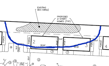
This detail from a schematic of the Hideaway Lane site plan shows the location of houses within a bioswale buffer zone. The blue line indicates the buffer zone boundaries. The shaded area is the bioswale. The top of this image is the eastern edge of the site.
Wendy Woods asked about the bioswale on the east edge of the site. Portions of two of the proposed homes are located within a 25-foot natural features buffer around the bioswale.
DiLeo explained that the houses are planned for the same location as in the previous Hideaway Lane project, which was never completed. At that time (in 2005 ) a bioswale was built that turned into a “full-fledged wetland,” DiLeo said, which the city is now protecting with a buffer zone. If the previous project had been built, the houses would have been located there already, she said. That’s the rationale for allowing the houses to encroach into the buffer. She stressed that the houses would not be located in the actual bioswale/wetlands, just in the buffer zone.
Woods wanted some assurance that the basements for those homes wouldn’t have water issues. Bruce Michael of Ojibway Development responded, as the developer’s representative. He said the short answer is no, the basements won’t flood. The bioswale is designed to handle runoff from the houses along the eastern edge of the property, he said – describing it as basically a stormwater management facility. The rest of the runoff flows westward onto Hideaway Lane and down into an underground piping system.
Ken Clein noted that one of the houses is on the edge of the 25-foot buffer from Traver Creek. He wondered how the creek would be protected during construction – because it’s a fairly sensitive waterway. DiLeo said that the planning staff isn’t charged with monitoring at that point, but the city’s land development coordinator would visit the site regularly and could see if there was any disturbance. Michael provided additional details about how the developer intended to protect that area, saying that they recognized it was a sensitive site. “Preventive measures are good,” Michael said.
Michael also noted that the previous developer had been required to get a wetland fill permit from the Michigan Dept. of Environmental Quality, yet those permit requirements hadn’t been fulfilled. Representatives for the current developer contacted the MDEQ to see what they need to do, Michael said. MDEQ officials told them there was no legal responsibility to fulfill those requirements, he said, but “we voluntarily stepped up from Day One and said we’ll do that.” For example, an area behind the existing townhouses was supposed to be a wetland but was never put in, he said. So now, a wetland will be constructed there.
In general, Michael described the property as “an extremely disturbed site,” saying that at one time it had been a dump. He explained several measures that the developer is taking to mitigate issues related to creating wetlands on the site and enhancing the existing wetlands.
Responding to another query from Woods, Michael indicated that new trees to mitigate those removed during construction would be planted throughout the site.
Diane Giannola asked if there was any common open space on the site. Michael replied that people would probably use the area near Traver Creek, or go to the nearby Leslie Park golf course. He noted that the developer is making a contribution to the parks system. [According to the development agreement, that contribution of $11,780 will be used for improvements in Leslie Park golf course, Leslie Science & Nature Center, or for "other parks within a reasonable walking distance of the site."]
DiLeo elaborated, saying that the development will meet the minimum requirement for active open space of 300 square feet per dwelling unit. She noted that front porches count as part of this calculation.
Sabra Briere asked about the natural features disturbance and alternative mitigation plans. She wondered if the developer had submitted other alternative mitigation plans. She noted that her question came in the context of a city council discussion the previous night, related to the proposed 413 E. Huron project. Several councilmembers had raised concerns about that project’s impact on natural features. Briere represents Ward 1 on the city council.
DiLeo replied that the Hideaway Lane developer had submitted four different layouts for mitigation, but the one being recommended by planning staff results in the least amount of disturbance to the site’s natural features, she said. Briere indicated that when the site plan goes before the city council, it would be good to have an explanation included in the staff report, describing the different alternatives.
Briere also wondered how the contribution-in-lieu payment for natural features mitigation could be used. DiLeo said it could be used for a variety of things, including street trees as well as work related to the city’s natural areas preservation program (NAPP).
Hideaway Lane: Commission Discussion – Density, Layout
Diane Giannola noted that the zoning was R4A (multi-family dwelling), yet the development was for single-family homes. Alexis DiLeo explained that the housing units in an R4A zoning district aren’t required to be attached, if they’re in a group setting on one parcel. The units will be part of an existing condominium association.
Sabra Briere asked about the side setbacks for these houses. Is it possible to cluster units in an R4A district so that the development maximizes the amount of available open space, even though the buildings are designed as single-family homes? DiLeo replied that “our code doesn’t make that easy.” Every building in R4A is expected to have a 20-foot setback, she said, because the expectation is that the buildings would be large with multiple units in each building. So there’s a dilemma with this particular project, she said. It’s proposed as a planned project to allow for smaller side setbacks. Briere described it as “an interesting problem.”
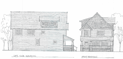
Briere also asked to see a drawing of the buildings, which had not been included in the meeting packet. [.pdf of architectural rendering and floor plans]
Briere also wondered if any of the units would be designed to be accessible for people who are “physically limited.” Michael replied that anyone who is handicapped or wheelchair-bound would have difficulty getting up the front porch steps. A ramp could be installed in the garage, he said, and some of the units have a first-floor master bedroom and bath, but the second floor would be “awkward.” Usually if a customer wants certain modifications to the layout, that can be accommodated, Michael said.
Kirk Westphal asked DiLeo to speak about the benefits of arranging the houses as they are on this site, calling it a rarity to see this kind of configuration. [.pdf of Hideaway Lane site plan]
DiLeo described this kind of compact development as similar to the Old West Side. The sizes of the houses are somewhat larger, she said, but the setbacks and placement of the buildings are similar to the Old West Side. Driveways are short, yards are relatively small, and homes are close to each other. In terms of infrastructure, she said, there are more efficiencies when buildings are clustered closer together. “There’s a lot of sharing of elements,” she said.
Westphal asked whether the lower cost of infrastructure per dwelling would affect the cost of the housing. DiLeo ventured that the construction cost per unit might be lower, but that wouldn’t necessarily affect the sale price. It would depend on whether the developer passes along the savings.
Ken Clein supported this type of denser development, and said the design seems to work pretty well. He asked some clarificational questions about the design, and encouraged adding another window to the rear of the houses.
Hideaway Lane: Commission Discussion – Railroads, Buses & Pedestrians
Wendy Woods noted that the Ann Arbor Railroad runs along the south edge of the property. She wondered what kind of buffer would be provided between the homes and the railroad. Alexis DiLeo replied that the railroad is much higher – it would be a very steep climb up to the tracks, and the steepness itself is somewhat of a deterrent. The incline is also fully vegetated with trees and brush, she said. “A small child could not really make their way up that incline. Now, nothing is going to stop a teenager,” she added, “but they have slightly more wherewithal to get out of the way” if a train comes.
Woods asked if there were any plans for a snow fence or other barrier. Bruce Michael of Ojibway Development replied that it’s about a 25-30 foot grade difference between the Hideaway Lane site and the railroad – the tracks would be higher than the tops of the houses. He said a “green screen” of evergreens is planned on the property that would deter most people from climbing up to the tracks.
Kirk Westphal clarified with DiLeo that there’s no legal crossing of the tracks at that location. Responding to another query from Westphal, DiLeo said that if someone wanted to cut through to Plymouth Road to catch a bus, there isn’t an easy way to do that. They’d have to cross the railroad tracks illegally and then go through another property. Even if they wanted to cut through further south – where it would be easier to cross the tracks – they’d have to cross Traver Creek, she said. “I’m a regular bus rider,” she said, “but I’m not sure I’d be willing to cross a creek.” Michael added that “you’d have to be a mountain climber” to get across.
Sabra Briere noted that Traver Road doesn’t have bus service. She wondered if the developer had worked with AATA to discuss the possibility. No, Michael said. Because the homes are single-family houses with attached garages, it’s likely that most residents will have cars, he said.
Briere wanted to ensure that there would be sidewalks so that it would be easy for students to walk to Northside Elementary School. Michael responded that there are sidewalks in front of the property as well as sidewalks internal to the site.
Outcome: In three separate votes, commissioners unanimously (1) recommended approval of the Hideaway Lane site plan and development agreement; (2) authorized the project’s anticipated disturbance of the natural features open space; and (3) recommended approval of an alternative mitigation plan for the site. The site plan, development agreement and alternative mitigation plan require city council approval.
State Street Center
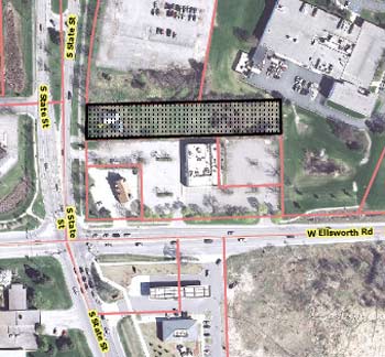
On the agenda was a proposed site plan for State Street Center, near the intersection of State and Ellsworth.
The plan calls for demolishing a vacant 840-square-foot house on this site. In its place, the developer plans a one-story, 1,700-square-foot drive-thru restaurant facing South State Street and a one-story, 6,790-square-foot retail building behind the restaurant. The driveway off South State Street would be shifted and widened. The site would include 39 parking spaces, as well as covered bicycle parking between the buildings.
The project, estimated to cost $900,000, would also require rezoning the site from O (office) to C3 (fringe commercial).
The development is located adjacent to a new Tim Hortons restaurant, which opened last year. There is no driveway connection between the two sites, however. Planning staff indicated that such a connection was encouraged, but the two property owners would not agree to it.
The planning staff recommended postponement after discovering that the city’s official zoning map had been incorrectly labeled. It showed the site as zoned C3, and the developer had made plans based on that erroneous labeling. But during background research for this proposal, planning staff discovered that the site actually had been zoned as O (office) in 2003. The postponement is intended to allow the developer to submit a rezoning request. The proposal will likely be taken up again at the commission’s April 2 meeting.
The property is owned by Jack Schwarcz of Oak Park, Mich.
State Street Center: Public Hearing
One person spoke during the public hearing on this project: Thomas Partridge. He told commissioners that they should hold joint meetings with the city’s human rights commission and health and human services advisory board to tackle issues of affordable housing. The commission shouldn’t simply forward site plans to city council “willy nilly,” without looking at the project’s human impact. Those impacts might include air pollution, noise pollution, livability, affordability and accessibility. Ann Arbor was built on native American territory, he said. Now, it’s just a high-priced, segregated city.
Kirk Westphal, the commission’s chair, noted that the public hearing would continue, if and when the project is brought back to the commission for consideration.
State Street Center: Commission Discussion
Diane Giannola asked about signs for the development. Noting that the retail building will be behind the restaurant, she wondered if it would be difficult to see from the road.
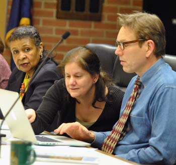
From left: Planning commissioners Wendy Woods, Diane Giannola and Ken Clein at the March 19, 2013 meeting.
City planner Alexis DiLeo replied that it would likely be challenging to see the building, especially given the depth of the parcel and the speed at which vehicles travel along South State. She said the developer would need to go through the city’s sign permit process for a ground sign – because the city doesn’t allow taller pole signs.
Giannola also asked if there was a connection for vehicles to travel between this site and the adjacent property where Tim Hortons is located. There is no connection, DiLeo said, adding that city planner Chris Cheng had worked hard trying to get the property owners to agree to it. “There is a tremendous personal difference” between the two property owners, she said. “It’s a civil matter.” It won’t likely happen until there’s an ownership change on one or both of the parcels, she said.
Planning manager Wendy Rampson elaborated, saying that the city doesn’t have an access management code that would require such a connection.
Eleanore Adenekan asked about the impact on the property’s landmark trees. DiLeo replied that none of the trees will be taken down, but the city is treating the site as though one of the trees will die, because of likely damage to its root system. [The staff report indicates that three trees will be impacted. New trees to mitigate that impact will be planted along the northeast and southeast corners of the site, as well as between the two buildings.]
Tony Derezinski wondered whether more public meetings would be required, in light of the rezoning. Rampson noted that under the city’s citizen participation ordinance, typically a public meeting would be required when a parcel is being considered for rezoning. However, notices about this project have already been sent out twice, and another one will be sent out again to property owners within 1,000 feet of the site. Given that the rezoning is being caused by the city’s error, Rampson said she determined that a public meeting wouldn’t be required. She added that most of the nearby property, if not all of it, is non-residential.
Sabra Briere wondered if there was any residential property in Pittsfield Township that’s within 1,000 feet of the site. Rampson wasn’t sure, but didn’t think so. Briere requested that Pittsfield Township be notified of this site’s possible rezoning.
Wendy Woods requested more information about the traffic in that area, when the project returns to the commission for consideration. Derezinski asked about the timetable for installing a roundabout at the nearby intersection of State and Ellsworth. Rampson indicated the project was scheduled for this summer. [According to information on the Washtenaw County road commission's website, construction is expected to begin this spring and be completed by the University of Michigan's first home football game, which is scheduled for Aug. 31.]
Kirk Westphal asked planning staff to check on how the proposed project and rezoning would fit with the recommendations of the South State corridor plan.
Outcome: Commissioners unanimously voted to postpone the project.
APA National Planning Conference
The commission considered a resolution authorizing the reimbursement of travel, lodging, registration and other expenses for Kirk Westphal – the commission’s chair – to attend the American Planning Association’s National Planning Conference in Chicago. The conference runs from April 13-17.
Planning manager Wendy Rampson reported that she and Westphal will be making a presentation along with Matt Naud, the city’s environmental coordinator, and Jamie Kidwell, who was the point person for developing the city’s recently adopted sustainability framework. The topic will be how to take a municipality’s existing planning documents and turn them into sustainability plans, Rampson said. The panel will be moderated by Julia Parzen, founding coordinator and “weaver” of the Urban Sustainability Directors Network. The Ann Arbor contingent plans to travel to Chicago by train, Rampson said.
Rampson noted that the planning commission’s bylaws require approval of such expenditures. She said there’s money in the planning unit’s budget for this expense. [Responding to a follow-up query from The Chronicle, Rampson said that the total for Westphal's trip is estimated to be $1,500. That amount includes the $695 conference registration, train travel, shared lodging for five nights, and per diem for food. For the current fiscal year, the planning unit's total conference and training budget was $8,000. Of that, $4,849 has been spent, not including the upcoming APA conference.]
Ken Clein indicated that information from the conference could provide substantial benefit to the planning commission and community at large. He characterized it as a “real value,” especially because it was being held at a location that’s relatively close to Ann Arbor.
Wendy Woods, the commission’s vice chair, asked whether it was appropriate for Westphal to recuse himself from this vote. He agreed, turning over the meeting to her and moving to sit in the audience while the other commissioners voted.
There was no further discussion.
Outcome: Commissioners unanimously authorized reimbursement of travel, lodging, registration and other expenses for Kirk Westphal to attend the American Planning Association’s National Planning Conference in Chicago. Westphal recused himself from the vote.
Communications from Council
Sabra Briere, who serves as on city council and is the council’s representative to the planning commission, reported on action at the council’s meeting the previous night, March 18. There were three major items that related to the commission’s work.
First, the council voted to postpone action on a site plan and necessary zoning for the Summit Townhomes project, located at 2081 E. Ellsworth Road. March 18 was the first time the site plan had been before the council. But the R3 (townhouse district) zoning for the property, annexed from Pittsfield Township, had been previously considered by the council, and referred to the planning commission for re-review. The planning commission subsequently confirmed its original recommendation for R3 zoning on Feb. 21, 2013.
Briere told commissioners that the council on March 18 had asked that the planning commission take yet another look at that property. She said the council wanted the planning commission to get back with a recommendation by the council’s second meeting in April, “so I suspect it’s going to appear on [the commission's] next agenda. There’s still some concern about the correct zoning.” [In fact, the council did not provide specific direction to the commission or planning staff, and simply postponed the item until the council's April 15 meeting. In a phone conversation with The Chronicle later in the week, planning manager Wendy Rampson indicated that there are no plans at this point for another re-review by the planning commission.]
The second item that Briere reported was a resolution approved by the council directing the planning commission to review the city’s D1 zoning, with details still to come regarding the scope and deadlines for that review.
The council also had postponed action on a site plan for 413 E. Huron, Briere reported. The design for that project had changed, she said, with new drawings shown by the developer at the council meeting. Those last-minute changes, coupled with questions regarding the project’s natural features mitigation plan, had prompted the postponement until the council’s April 1 meeting, she said. Briere indicated that there might be further changes to the building’s design by then.
On March 19 planning commissioners did not discuss any of the items that Briere reported.
Present: Eleanore Adenekan, Sabra Briere, Ken Clein, Tony Derezinski, Diane Giannola, Kirk Westphal, Wendy Woods.
Absent: Bonnie Bona, Eric Mahler.
Next regular meeting: Tuesday, April 2, 2013 at 7 p.m. in the second-floor council chambers at city hall, 301 E. Huron St., Ann Arbor. [Check Chronicle event listings to confirm date]
The Chronicle survives in part through regular voluntary subscriptions to support our coverage of publicly-funded entities like the city’s planning commission. If you’re already supporting The Chronicle, please encourage your friends, neighbors and coworkers to do the same. Click this link for details: Subscribe to The Chronicle.



$1500.00? That’s a lot of money to be spent in one place for one individual. That being said, I’m sure it’s a worthwhile conference. However, with several years at least in the past with parks facilities threatened w/closure and continuing discussion of shortfalls in essential services, if this was important a conference to Mr. Westphal for him to attend, he would perhaps have budgeted for it from his personal resources, not the city.
It’s great that the new restaurant will have covered bicycle parking, but does the City have any plans for making it possible to get there on a bike?
Re (1) and we are also apparently sending three other people. If at the same rate, that is $6,000 for a single conference.
Have we as a city really examined travel policy lately? I understand the value of professional conferences in the education of the individuals concerned, but I wonder whether in a time we don’t have the recommended bare minimum police force we shouldn’t look at the total spent on staff travel. And what about council? At one time the DDA was sending lots of people to IDA conferences. That is how we got Boulder, Boulder all the time.
(Yes, I went to commissioner conferences early in my tenure on the BOC at taxpayers’ expense, but stopped after a while.) (I also went to Michigan planning conferences, but at my own expense.)