Two Residential Projects Get Go-Ahead
Ann Arbor planning commission meeting (Dec. 18, 2012): Winning praise for its design, the site plan for a proposed three-story “flatiron-style” building at 544 Detroit received a recommendation of approval from planning commissioners at their most recent meeting.
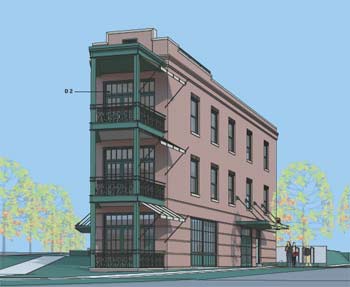
A rendering that shows the proposed design for 544 Detroit St., at the corner of Detroit and North Division.
The project is located at the triangle tip of Detroit and North Division, just southwest east of the Broadway bridge – the site of a long-abandoned gas station. The new building would include offices on the first floor and residences on the upper two floors.
It was one of two residential projects that will now move to the Ann Arbor city council for consideration. The other one – Blue Heron Pond – is a townhome development located at the northwest corner of West Liberty and South Maple. A previous project at that location had languished under a different owner after one building was constructed in 2006. The new project includes nine buildings with a mix of two- and three-bedroom rental units.
In other action, rezoning requests for two other projects did not get recommendations for approval. A rezoning request and area plan waiver for 2271 S. State St. – which would allow for auto sales on the site, where Pilar’s Tamales restaurant had been located – was postponed. Planning commissioners wanted to hold off until a South State Street corridor study is completed. That’s expected to happen by the spring of 2013.
And receiving a technical denial was a rezoning request for 490 Huron Parkway from R3 (townhouse district) to R1B (single-family dwelling). Of the six commissioners at the Dec. 18 meeting, only five supported the request. It needed six votes for a recommendation of approval. Bonnie Bona voted against it, saying she supported more dense development in that area, which is located near Huron High School along a bus line. No construction is proposed at this point.
Commissioners also approved the city’s proposed capital improvements plan (CIP). The plan covers the fiscal years 2014-2019, and includes a list of major capital projects, both those that are funded and those for which funding hasn’t yet been identified. [.pdf of CIP for FY 2014-2019]
544 Detroit
A plan to construct a three-story building at 544 Detroit St. with offices on the first floor and residences on the upper two floors was on the Ann Arbor planning commission’s Dec. 18 agenda.
The site – a triangle at the corner of Detroit and North Division – is in the Old Fourth Ward Historic District. The plan calls for demolishing a 560-square-foot gas station, which has been vacant for more than 30 years, and constructing a new 4,077-square-foot building. The city’s historic district commission (HDC) voted to issue a certificate of appropriateness to allow the demolition and new construction to occur. That happened at the HDC’s Oct. 11, 2012 meeting. A new curbcut is planned off Detroit Street, replacing other curbcuts on the site.
The proposal is a “planned project,” which allows modifications of the area, height, and placement requirements related to permanent open space preservation – if the project would result in “the preservation of natural features, additional open space, greater building or parking setback, energy conserving design, preservation of historic or architectural features, expansion of the supply of affordable housing for lower income households or a beneficial arrangement of buildings.” However, all other zoning code requirements must still be met – including the permitted uses, maximum density, and maximum floor area.
In this case, a planned project is requested to allow an additional 3.5 feet of building height for a “decorative parapet” on the building’s north end and a stair enclosure to access a roof deck from the third floor. The planned project also is needed to accommodate shorter front setbacks – 5 feet, versus the required 10-foot setbacks along Detroit and North Division streets, and a 19-foot rear setback, rather than the required 39 feet.
A modification is requested to the landscaping buffer to reduce the required width and allow for a six-foot-tall privacy fence on the east side. The city also requires that the project replace any bricks in Detroit Street that are affected by the construction.
The project’s architect is Marc Rueter of Ann Arbor, who was on hand to review the details, along with other representatives for the owner, Jack Epstein of Rockville, Maryland. According to a staff memo, the owner intends to pursue brownfield tax increment financing for the site.
544 Detroit: Public Hearing
Five people spoke during a public hearing on the project.
Christine Crockett, president of the Old Fourth Ward Association, noted that the city’s historic district commission had endorsed the project unanimously. The property “has distinguished itself for its blight,” she said, yet it’s the gateway to Ann Arbor’s oldest neighborhood. The proposed building has been beautifully designed, and will serve as a magnificent gateway into the historic district. It has elements that resonate with the neighborhood, and many artistic elements that aren’t required. She thinks the developer agrees that architecture makes the best public art, and this building will be wonderful public art. Crockett noted that the property is zoned C1 – and the building’s scale, massing and overall design fits perfectly. She pointed out that the last building before the gas station was built was a barn.
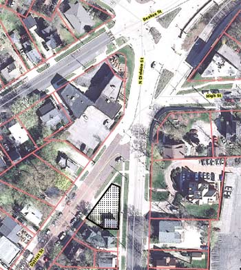
Aerial view of 544 Detroit Street (outlined in black). The street at the bottom center of this image is North Division – Detroit Street angles in from the bottom right.
There was a neighborhood meeting about the project, and Crockett reported that people were delighted with the design and that everyone driving over the Broadway bridge would see this beautiful structure. She acknowledged that the plan calls for the height to exceed the zoning in that area, but observed that the lot sits lower than the adjacent building.
Far less enthusiastic about the project was Ed Mahony, who owns 524 N. Division – two houses down the street from the proposed building. Though he’d like to see the blight cleaned up, he doesn’t want a three-story building there. It would totally block his view from his front porch. He noted that most houses in the neighborhood are less than 2,000 square feet and are set back from the street. He asked commissioners not to allow any variances so that the developer would have to reduce the size of the building.
Three people associated with the project addressed the commission. Dan Williams of Maven Development described the site as unique. He noted that two neighborhood meetings had been held about the proposal, and there had been lots of support for the building’s scale and character.
Architect Marc Rueter talked about the “tremendous vision” that Williams had for the property. Ann Arbor has only a few locations where diagonal streets create these unique building sites. That meant there was the opportunity to build a traditional flatiron-style building, he said. There’s another one – a two-story flatiron-style building – located at the intersection of Detroit and Fifth, across from Kerrytown Market & Shops. The idea is to push the building forward into the point of the triangle, Rueter explained, creating a very narrow “nose” where the balconies will be located. In the back, the only paving will be for a turnaround area – covered parking will be tucked underneath the building’s second floor, in the back with a new entrance off Detroit.
Serge van der Voo, the project’s landscaper, described various details about the trees and other plantings that are planned for the site. American elm trees – the Princeton variety, which are disease resistant – are recommended as street trees on the edges of the site. Plant beds would be installed around the foundation of the building, so there would be no lawn. Arrowood Viburnum would be put in next to the brick facade, with Broadmoor Juniper shrubs planted along the foundation and Liriope planted as ground cover. In the point of the triangle, Walkers Low Catmint – a long, blue-flowering perennial – would be planted. Trees along the back of the site include Amelanchier and Nigra Arborvitae.
544 Detroit: Commission Discussion
Sabra Briere wondered if the project needed approval from the city’s zoning board of appeals, because of requested changes to the conflicting land use buffer. City planner Jill Thacher replied that it does not require ZBA approval.
Responding to a question from Briere about refuse collection, Thacher explained that residents will use 96-gallon carts that they roll onto Detroit Street for collection – there won’t be a dumpster on the site.
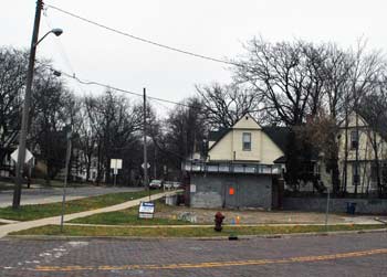
Looking south at 544 Detroit St. The one-story gray building is a former gas station that’s been abandoned for over 30 years. Detroit Street is in the foreground, with South Division on the left side of this view.
Briere also requested that future staff reports include images that provide context to the site – showing surrounding buildings and lots to see how they would be affected by an infill project like this one. She concluded her remarks by complimenting the landscape designer, saying that using catmint on the corner point coordinates well with the planting beds at the Broadway bridge, which also include catmint.
Diane Giannola asked what the historic district commission said about the project. Thacher recalled it as a very short but glowing conversation, noting that commissioners were pleased by the brick facade and fenestrations. There were no concerns about massing or size, she said, and the HDC vote had been unanimous.
Tony Derezinski wondered whether the project could be done without the requested changes to the conflicting land use buffer. Thacher replied that the building as proposed would not work. It would push the parking area so far forward, away from the back edge the lot, that you’d need to put the building on stilts or put parking underground, she said.
Derezinski described it as a very unusual lot – it took a lot of creativity to design a building for the site, and he thought they’d done a good job. He didn’t want the lot to remain as it is.
Saying the answer wouldn’t affect his vote, Eric Mahler asked about the project’s impact on the neighbor to the south. Thacher noted that the existing retaining wall would stay in place. She also pointed out that the house is a rental property.
Ken Clein asked several questions to get an idea about the price range for the two condo units. Dan Williams said they aren’t targeting students, but would more likely be sold to empty nesters. He indicated that the pricing for the units hasn’t been set.
Clein described the building’s design as handsome, saying that it fit well into the historic neighborhood. He understood that nearby residents would lose their “viewshed.” He noted that if the required setbacks stayed in place, it wouldn’t be a buildable site. The only hope would be for the city to buy the land and turn it into a park, he quipped – a remark that prompted a chuckle from Sabra Briere, who also serves on the city council.
Bonnie Bona liked the plan to have parking under the second floor – because it was covered, yet still open, she said. She also hoped that the project’s plans for energy conservation actually happen, and noted that often the commission has been disappointed in that regard by projects after they’re built. She noted that because of its density, the building itself was energy-conserving.
Relative to the building’s massing, Bona noted that even if the setbacks were enforced, zoning would allow it to be nearly as tall as it is in the current design. As a bookend to the neighborhood, it will provide a buffer to one of the area’s primary streets, she said.
Outcome: Commissioners unanimously recommended approval of the site plan and changes to the required landscaping buffer. The project will next be considered by the city council.
South State Rezoning
A rezoning request and area plan waiver for 2271 S. State St. – which would allow for auto sales on the site – was on the planning commission’s Dec. 18 agenda. The city’s planning staff had recommended denial of the requests, noting that the changes did not align with uses in the city’s master plan for that area.
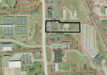
Aerial view showing 2271 South State Street. Most recently, Pilar’s Tamales had been located in a building at the front of the site. The large lot on the right side of this image is a parking lot for Ann Arbor Public Schools buses. The property on the left of the image is the University of Michigan tennis facility. On the bottom left is a portion of the Edwards Brothers printing business.
The 2.24-acre site is located on the east side of South State, across the street from a University of Michigan tennis facility. Most recently, Pilar’s Tamales restaurant was located there, though that building is now vacant. The owner, Capital Investment Co., requested rezoning from M1 (limited industrial) to M1A (limited light industrial) so that an auto dealership could be located there. The plan calls for renovating an existing 1,868-square-foot building that fronts South State, to use as a sales office, while using the rear warehouse as an auto repair shop. Repaired cars would be stored and sold in the front parking lot.
A previous project approved for that site in 1999 was started but never finished. The city’s master plan discourages commercial uses along South State, except for the sites adjacent to the Stimson and South Industrial commercial area. According to a staff memo, a corridor study that’s being developed for South State is expected to recommend a mix of office and residential uses for that area. The staff memo also notes that there are several compliance issues with the site, “including lack of required landscaping, an unfinished building foundation, deteriorated driveways and storm water drainage concerns.”
South State Rezoning: Public Hearing
Two people spoke during the public hearing for this item. David Diephuis, a resident of South State, told commissioners that he doesn’t support this project primarily because it doesn’t improve the South State corridor. He noted that the city has embarked on a corridor study with the goal of making the South State entrance into the city more attractive. This project doesn’t do that, he said. It might not appear that very much has changed along South State in the past 15 years, Diephuis said, but many property owners have improved their sites. He cited several examples, including the Produce Station, the Wintermeyer office buildings, the former Howard Cooper dealership, the relatively new office buildings on Oakbrook, and the detention pond in front of the FedEx building. In contrast, the proposal for 2271 S. State wouldn’t make a significant improvement to that site, he said. He hoped commissioners would recognize that it’s just not enough to warrant approval.
Representing the property owner was local attorney Scott Munzel. He noted that the current M1 zoning allows for only limited sales – on 10% of the building’s floor area, which would be about 100 square feet. That just wouldn’t work for auto sales, he said. There is no such constraint on M1A zoning. Munzel pointed out that the former Howard Cooper dealership – now called Germain of Ann Arbor – is located just down the street, so there are already similar uses along the corridor.
The site’s topography, which includes a significant grade drop, puts limits on potential uses, Munzel said. He noted that the current owners are somewhat risk averse. They’re willing to work through the city’s requirements to redevelop the site, but want to make sure they can do what they want on the site before moving forward. The first step is getting the site rezoned. Rezoning would be consistent with the existing master plan and its goal of encouraging economic development, he said. Munzel noted that the draft corridor study calls for office and residential uses along that part of South State, but there isn’t demand for that now.
Munzel also questioned the fairness of evaluating this rezoning request based on a corridor plan that’s not yet finished. If eventually there is demand for office and residential development, it would be easy for the owner to switch to that type of use. So approving the rezoning request would allow for better use of the site now, he concluded, while still allowing for potentially different uses in the future.
South State Rezoning: Commission Discussion
Sabra Briere pointed out that other rezoning requests along South State Street had been made and denied, in part because of the pending corridor study. She wondered when that study would be completed, and whether the current rezoning request would likely be approved in the context of the study’s recommendation.
Wendy Rampson, the city’s planning manager, said the corridor study will be on the commission’s agenda in January of 2013 with a recommendation that it be distributed to neighboring municipalities for input. The M1A zoning is not consistent with the study’s recommendations, she said. There are already other areas along the corridor that are zoned M1A – including the former Howard Cooper dealership – and she didn’t think there was a sense that more M1A areas are needed.
Responding to a query from Tony Derezinski, city planner Chris Cheng indicated that the owner would need to bring the site into compliance with the previously approved site plan before any additional work could be done, even if the rezoning is approved. He noted that auto repair is allowed under the existing zoning. It’s just the limit on sales that’s an issue. Rampson observed that none of the restaurants that had previously been in business on that site had been operating there legally.
Diane Giannola was hesitant to approve rezoning – it wouldn’t be consistent with other recent actions, when the planning commission had denied rezoning requests along South State. She advised waiting, and noted that if the commission recommended approval to allow this use, it would contradict their public statements about the kinds of uses they wanted to see in that area. Noting that the site has been vacant for a long time, she said she’d love to see it being used. But it’s too much of a contradiction with what the commission has been working on for the past two years, she said.
By way of background, in 2011 the commission recommended denial of two zoning requests along the South State corridor. The operator of Treecity Health Collective, a medical marijuana dispensary at 1712 S. State, asked that the location be rezoned from O (office) to C1 (local business). And the owners of Biercamp Artisan Sausage and Jerky had asked that 1643 and 1645 S. State St. be rezoned to C3 (fringe commercial district), which would allow their business to sell a wider variety of merchandise, including products not made on site. It has been annexed into the city from Ann Arbor Township with M1 zoning.
Responding to a question from Ken Clein, Scott Munzel indicated that the current owners have owned the site for about a year. He observed that not all of his clients get into a deal knowing what they’re actually getting into. But the owners are well-funded, he said, and think it’s a great spot to renovate and sell cars. They know they need to do significant work to get the site up to code, Munzel said. He suspected they would return with a new site plan at some point, tailored for what they’d like to do on the lot.
Eric Mahler said that if it weren’t for the pending corridor study, he’d have no qualms approving this request. He suggested postponing action.
Bonnie Bona told commissioners that she was struggling with the issue. She could imagine the site being used for something that didn’t require a lot of investment. The corridor study will give everyone a sense of what the community wants, but it could take years for all of the properties along that stretch to see their value increase to make the new uses feasible. She said she didn’t want to create a situation in which something is done that can’t be undone. So the idea of putting something there that doesn’t require a lot of investment now felt OK to her.
Directing a question to Munzel, Bona wondered what changes along State Street would need to occur in order for the current owners to consider a residential or office development there? Munzel noted that in general, when land values increase, auto dealerships – which require large lots – tend to move further out into the suburbs. With time, he could imagine there would be a change in demand for uses on that parcel. It’s a lovely site with some nice views, he said, and he could see some potential for development at the top, closest to South State. But it’s unclear how many years that might take. Part of it involves financing, he added – would a bank give a loan for an office/residential development there? That might be 5-10 years out. He said he had wondered about some kind of conditional rezoning.
Rampson suggested that commissioners decide whether to wait for the corridor study to be completed, or to decide whether the rezoning is appropriate for the future use of the site. She would not recommend that any temporary component be part of their action.
After further discussion, commissioners reached a consensus to postpone action until the corridor study is completed. That’s expected to happen by the spring of 2013. Commissioners also indicated that they wanted to see a survey of the property to reflect current conditions, or a revised site plan.
Outcome: Commissioners unanimously voted to postpone action on this request until the South State corridor study is completed. In the interim, they also requested a survey of the property to reflect current conditions, or a revised site plan.
Blue Heron Pond Townhomes
The site plan for a large townhome development at the northwest corner of West Liberty and South Maple was on the Dec. 18 agenda.
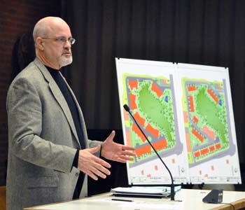
Architect Brad Moore describes the plan for Blue Heron Pond townhomes at the northwest corner of West Liberty and South Maple.
Blue Heron Pond is a planned project of 64 units on a 7.8-acre site that’s zoned R4B (multi-family dwelling). It’s the site of a development formerly called West Towne Condominiums that was started in 2005 but never completed. A building with 11 units has been constructed on the site, although the original developer – the Concannon Company – had planned to build 87 units.
The new owner, Norfolk Development, bought the property in the spring of 2012. The new $4.2 million project calls for constructing nine buildings in two phases. The first phase will include construction of four buildings along West Liberty, with the five other buildings in the site’s interior to be constructed at a later date. The complex will have a mix of two- and three-bedroom rental units ranging in size from 980 to 2,577 square feet, each with an attached one-car garage. Rents are expected to be in the $900 to $1,800 range.
The proposal is a planned project – rather than a by-right development – because a modification is being requested to the zoning requirements. Rather than the 20 feet between buildings that’s required in R4B zoning, the developer wants to reduce that amount to 15.7 feet between two of the buildings along West Liberty.
A large wetland in the center of the site will not be disturbed. A contribution of $26,000 to the city’s parks system has already been made, with the funds used for improvements at South Maple Park.
Blue Heron Pond Townhomes: Public Hearing
Brad Moore, the project’s architect, was the only person who spoke during a public hearing on this agenda item. He described the project, highlighting major differences between the former plan and the current one. The buildings now are smaller, reducing the intensity of development on the site. Open space has been increased while the amount of impervious surface has been reduced, as has the total number of dwelling units. The road, underground utilities, stormwater detention and other infrastructure will remain unchanged.
There will be four smaller buildings fronting West Liberty, rather than two large structures that were previously proposed. It’s the attempt to break up the building’s mass along West Liberty that prompted the request for a planned project, he said. They’re constrained in the building layout by the location of a water main and a road to the west, and are requesting a reduction in required space between two of the buildings.
He noted that the one building that’s already on the site has been completed and people are now living there. All but four of the new units will be townhouses. The other four will be stacked units, with the first floor handicap accessible.
Blue Heron Pond Townhomes: Commission Discussion
Bonnie Bona asked for more details about the wetland area. Scott Betzoldt of Midwestern Consulting replied that the wetland had been an existing feature on the site prior to the city’s approval of the previous site plan. The previous site plan had used it for rear-yard drainage, and the current site plan is proposing to do the same. Right now, because of the drought, the wetland is actually two small ponds, “but I assume it will return someday.” He said it wouldn’t surprise him if it were actually a manmade feature from way back.
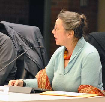
Sabra Briere, who serves on the Ann Arbor planning commission as well as the city council, representing Ward 1.
Responding to a query from Tony Derezinski, Moore said that they hope to build an observation deck by the wetland. The area is populated by ducks, herons and turtles, he said.
Derezinski also noted that the commission had received a communication from a nearby resident, Judith Marks. She indicated that at a neighborhood meeting earlier this year, Jim Franke – representing the developer – had stated that they’d start building on the north side of the site. But the recent staff report states that the buildings on West Liberty would be constructed first. She wanted clarification, so Derezinski asked, “Which is it?” Moore replied that the West Liberty phase would be constructed first.
Sabra Briere wondered whether the path around the pond would be accessible to people who don’t live in the development. Moore indicated that there’s a connection to the path from the public sidewalk, so it will be possible for people to walk around the pond.
Responding to a question from Eric Mahler, Moore explained that the first two buildings on the site would have both two-bedroom and three-bedroom units. As the developers sense the market demand, they’ll adjust the additional buildings internally based on the more popular configurations.
Mahler clarified that regardless of the number of bedrooms, there will be only one parking space per dwelling unit. Moore said that some buildings – including those along West Liberty – will actually have two internal spaces per unit, because cars will be able to park front-to-back. There will also be a spot in front of the garage. In units with walk-out basements, the garage will only be large enough for one car.
Mahler noted that the project isn’t large enough to warrant a traffic study – but West Liberty can be a high-traffic street. Will there be any restrictions on turning into or out of the site onto West Liberty at certain times of the day? Moore said they aren’t proposing any turning restrictions. It’s believed that residents will learn when it’s difficult to make a left turn onto West Liberty, and use the exit onto Maple instead. Mahler noted that Maple isn’t necessarily less busy. Overall, he said, it’s nice to see the site developed and this is a big improvement over the previous site plan.
Diane Giannola asked how much visitor parking was available. Her concern is that because there’s no street parking in that area, there might not be enough parking for visitors. Matt Kowalski of the city’s planning staff reported that there will be 36 total spaces in surface parking throughout the development.
Bona noted that the units look smaller than the previous proposal, and she wondered if there had be a marketing change. There area 23 fewer units, and those units are smaller. “It’s hard to imagine a developer that’s not maxing out the square footage on a site, so there must be some reason why you decided to do that,” she said.
Moore said the developer felt the site had been “too maxed out” as it was previously configured, and that it would have been a detriment to marketing it. They felt they’d have a more marketable product if it were less dense.
Bona complimented the design, saying that the changes in the garages are significant. “That original building – just a bunch of garage doors slammed up against the road – always felt a little uninviting,” she said.
Outcome: Commissioners unanimously recommended approval of the Blue Heron Pond site plan. It will move to the city council for consideration.
Huron Parkway Rezoning
On the agenda was a rezoning request for 490 Huron Parkway from R3 (townhouse district) to R1B (single-family dwelling). It would allow the currently vacant 1.22-acre site, located north of Ruthven Park, to be divided into three separate lots. City planning staff had recommended the rezoning, and noted that the adjacent parcel at 500 Huron Parkway is also zoned R1B.
Huron Parkway Rezoning: Public Hearing
Greg Elliott told commissioners that he is an Ann Arbor attorney who was filling in for the owner, Louis Johnson of the Johnson Building Group, and the project engineer, Brad Cousino of Terratek Design. He said he’d be happy to answer any questions.
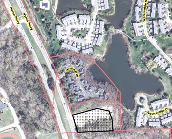
Aerial view of 490 Huron Parkway, outlined in black. The major road running west of the site is Huron Parkway. The land on the far west of this image is the site of Huron High School.
Arlene Shy said she represented the Heritage Ridge condo development, located just north of the site. They were concerned about the grading on a steep slope located between the condo development and the site, which she said needs to be stabilized. The way that it’s been left is very risky, she said. The developer for that project – also Johnson Building Group – hasn’t replaced sod following the installation of a water hydrant on the property, Shy said, and several large trees had also been cut down as part of that project. Those trees haven’t been replaced, either. She reiterated that nothing has been done to stabilize the bank on that very steep slope, and it was a major concern for the Heritage Ridge homeowners.
Huron Parkway Rezoning: Commission Discussion
Tony Derezinski began by noting that he had attended a public meeting on this rezoning request in the summer, where the issue of the slope stabilization had been raised. He asked the city’s planning staff if action was being taken to resolve it.
City planner Chris Cheng replied that the city’s grading inspector has met with representatives of the developer, but the problems haven’t yet been taken care of. However, Cheng pointed out that the problems are not on the 490 Huron Parkway site. Rather, the steep bank is on adjacent land that’s owned by the same developer, where a single-family house is being built. Cheng said the city would withhold a certificate of occupancy for that house until the problems have been resolved.
Responding to another query from Derezinski, Cheng said that if the rezoning were to be approved, the parcel could be divided into a maximum of five lots – but there are no proposals at this time to do that.
Sabra Briere observed that the lot is about 130 feet from the busy intersection at Geddes and Huron Parkway. Has there been any consideration of traffic safety? She said she’s been hearing about significant issues with speed and safety at that intersection.
Cheng reported that the city’s traffic engineer approved the rezoning, and that a traffic study wasn’t deemed necessary because of the anticipated low volume of traffic associated with the site.
Responding to a question from Ken Clein about stormwater management, Cheng indicated that single-family homes don’t require stormwater management systems. Planning manager Wendy Rampson added that single-family houses do have to meet the city’s requirements related to changes in impervious surface. That’s part of the permitting process.
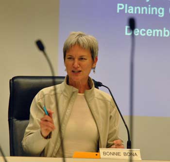
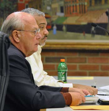
Bonnie Bona led the Dec. 18 planning commission meeting, in the absence of chair Kirk Westphal and vice chair Wendy Woods.
Bonnie Bona asked about impervious area for townhouses compared to single-family houses – has the city staff given any thought to that? Cheng answered that unlike single-family houses, townhouse developments require a site plan and therefore must come through the planning commission and the city council for review.
Bona wondered what the taxable value would be on the site, if the lots were divided for three single-family homes compared to 12 townhouses. Cheng replied that the vacant lot has been assessed at $300,000 – but the market would dictate the value after it’s developed. He noted that the lot has been vacant for more than 30 years, and he ventured that if it had been feasible to build 10-12 townhomes there, it probably would have happened already.
Bona then directed her questions at the developer’s representative – the attorney, Greg Elliott. She noted that Huron Parkway is on a bus line, and that most people who live in single-family homes of the size that would likely be built there don’t ride buses. There’s limited property to develop within the city, and she said it would be a shame to develop property that wouldn’t add to the usage of the bus system. She wondered why the developer would put single-family homes there, in an area surrounded by townhomes?
Elliott pointed out that single-family homes are a permitted use on the site. The layout for townhomes would be a practical problem because of the topography, he said, and there hasn’t been a market for them. He noted that Louis Johnson had previously submitted a plan for townhouses there, but it didn’t work out.
Bona said she couldn’t support the rezoning. With 70,000 people commuting into Ann Arbor each day, it didn’t make sense to build single-family homes in that area. “Single-family homes should be built in townships, where they don’t want bus service,” she said.
Clein indicated he was on the fence about the rezoning. He wasn’t sure what the benefit would be for the city. It’s true that there would be less traffic with single-family homes compared to townhomes, but there would be more impervious surface with a single-family house.
In response, Eric Mahler cited what he saw as several benefits to the city. The vacant parcel will be developed and more taxes will be collected – regardless of whether residents who live there ride the bus. Jobs will be created, he said, and it will be a better situation than exists now.
Outcome: The vote on the rezoning was 5-1, with Bonnie Bona voting against it. Because a rezoning needs six votes to achieve a recommendation of approval, the request received a technical denial. It will be forwarded to city council for consideration.
Capital Improvements Plan 2014-2019
At its Dec. 18 meeting, Ann Arbor planning commissioners were asked to approve the city’s proposed capital improvements plan (CIP). No one attended a public hearing on the topic.

Deb Gosselin briefed planning commissioners at their Dec. 11 working session – pictured here – prior to presenting the capital improvements plan at their Dec. 18 regular meeting.
The plan covers the fiscal years 2014-2019, and includes a list of major capital projects, both those that are funded and those for which funding hasn’t yet been identified. [.pdf of CIP for FY 2014-2019] Required by state statute, the CIP must be developed and updated each year, looking ahead at a six-year period, to help with financial planning for major projects – permanent infrastructure like buildings, utilities, transportation and parks. It’s intended to reflect the city’s priorities and needs, and serves as a guide to discern what projects are on the horizon.
This year, there are 377 projects listed in 13 different asset categories. In the report, new projects are indicated with gray shading. They include renovating and/or remodeling five fire stations, 415 W. Washington site re-use, a park at 721 N. Main, urban park/plaza improvements, several street construction projects, a bike share program, and the design, study and construction of a new rail station.
Planning commissioners had been briefed on the CIP at a Dec. 11 working session by Cresson Slotten, systems planning unit manager, and Deb Gosselin, systems planning engineer. Both Gosselin and Slotten attended the commission’s Dec. 18 meeting to answer additional questions.
This year, the report also includes results from an online survey of residents. More than 200 people responded, and their input is being used to help prioritize projects. [.pdf of survey responses (aggregate)] [.pdf of survey responses (open response)] To make the final CIP information more accessible, the city is also planning to launch a CIP mapping system that will indicate the locations of projects, and allow users to click on the location for details about the project. That’s expected to be posted later this month as part of the city’s GIS (geographic information system) site.
Capital Improvements Plan 2014-2019: Commission Discussion
Sabra Briere asked if there was a way to indicate whether the current plan reflects any changes in priorities for projects, compared to previous years. Deb Gosselin replied that it should be possible to create a report like that.
Briere then noted that remodeling and/or renovations for fire stations were listed in the report. She said that the inclusion of those projects reflects a staff priority that might change in the coming months. If priorities do change, Briere wondered what happens to the approved CIP impact that would have immediate impact on budgeting and staffing?
Gosselin replied that the staff is aware of ongoing discussions related to the fire stations. There’s always the flexibility to tweak the CIP, if necessary.
Planning manager Wendy Rampson added that from the staff’s perspective, a project can’t move forward unless it’s in the CIP. There are some projects that the council hasn’t yet made decisions on, so it’s better to include those projects in the CIP – even if no funding has been identified or approval given.
Tony Derezinski asked if the staff knew of any major changes in federal funding or other sources that might have an impact on the CIP. There’s nothing in the short-term, Gosselin said. But looking out six years or so, the city hopes to get federal funding to use for street and transportation projects, rather than using local millage funds.
Ken Clein asked about the item labeled “Ann Arbor Station NEPA/PE” with funding of $2.75 million from prior years. It relates to environmental assessment and preliminary engineering for a possible train station. It’s a component of a Federal Rail Administration grant that the city council accepted, and is required under National Environmental Policy Act guidelines. [For a detailed discussion by the council on this funding, see Chronicle coverage of their June 4, 2012 meeting.]
By way of additional background, 2014-2019 CIP contains two other line items related to the Ann Arbor Station: $2.6 million in 2015 for final design, and $44.5 million for construction, with no year designated.
Eric Mahler began by saying this was one of his favorite parts of the planning commission’s work. He asked about the line item for the drop-off station – $4.9 million in 2017. Gosselin replied that not all of the funding will come from the city. The plan for a new drop-off station had been pushed back to a later date, to give the city time to negotiate with other local governments to help with funding.

Cresson Slotten talked to planning commissioners at their Dec. 11 working session about the capital improvements plan (CIP). Slotten is manager of the city’s systems planning unit, which handles the CIP process.
Sabra Briere, who also serves on the city council, elaborated. The current drop-off station – at 2950 E. Ellsworth Road, near the intersection of Ellsworth and Platt – is located on a former landfill, she noted. The site is unstable and sinking, so the city plans to build a new station around the corner, on city-owned land. The expectation is that most people who use the drop-off station don’t live in the city, Briere continued. So the city’s solid waste staff is working with the county and other municipalities to build one station for the region.
As background, in December 2011, the city council approved a contract with the nonprofit Recycle Ann Arbor to operate the drop-off station, at no cost to the city, through June 30, 2016. According to a staff memo that accompanied the council resolution, the long-term plan for the station would be evaluated as part of the city’s solid waste plan update. A public hearing on a draft of that plan is set for Jan. 24 before the city’s environmental commission, on which Briere also serves.
Two actions related to the drop-off station are listed in the draft plan: (1) develop a report by June of 2014 with recommendations on the drop-off station as a regional facility and with expanded collection of materials; and (2) develop a plan for funding and cost-sharing partners with neighboring communities and the University of Michigan.
Referring to the overall CIP, Bonnie Bona asked how the public can get more information about it. Gosselin mentioned the new mapping feature that would allow users to identify projects geographically, and get details about each project by clicking on the location’s icon. It would be part of the city’s GIS site.
Bona also asked if the CIP included projects for which no funding has been identified. Yes, such projects are included, Gosselin said. She noted that the staff tries to identify at least the potential funding source, even if the funding hasn’t been secured.
Present: Bonnie Bona, Sabra Briere, Ken Clein, Tony Derezinski, Diane Giannola, Eric Mahler.
Absent: Eleanore Adenekan, Kirk Westphal, Wendy Woods.
Next regular meeting: Tuesday, Dec. 18, 2012 at 7 p.m. in the second-floor council chambers at city hall, 301 E. Huron St., Ann Arbor. [Check Chronicle event listings to confirm date]
The Chronicle survives in part through regular voluntary subscriptions to support our coverage of publicly-funded entities like the city’s planning commission. If you’re already supporting The Chronicle, please encourage your friends, neighbors and coworkers to do the same. Click this link for details: Subscribe to The Chronicle.


Not to be pedantic, but I want to raise two sanity-check questions regarding the 544 Detroit Street project. First, I don’t think that the site is actually East of the Broadway Bridge; my recollection of that neighborhood is that Detroit & Division is a bit southwest of the Bridge. Second, in the photo caption, I believe the view is looking South, and Division Street is on the left, not right.
With that said, thanks as always for the excellent local reporting!! The new Detroit Street project looks super cool and should be a positive addition to that part of town!
Re. geographic references to 544 Detroit St.: Yes, of course you’re correct – those two location indicators were wrong, and I’ve corrected them in the article. 544 Detroit is slightly southwest of the Broadway bridge, and the view in the photo is looking south, with Division Street on the left. My apologies. It’s rarely a good idea to work on a report after midnight.
The role of the planning commissioner and how they make judgments is ambiguous, at least to me, and I have served on a planning commission. I am referring specifically to the commissioner’s role in approving developments and rezonings. Is the role merely to apply ordinances, regulations, and master plans to the proposal and come up with a judicial ruling? But it seems to me that staff is there to cover those bases. It is the planning commissioners who listen to citizen input and take it into account. Presumably they also apply some broader community principles and consider more fully than staff might what the impact on adjoining parcels will be. (Recall University Bank’s long struggle for a revised parking lot?) Yet at times they declare themselves incapable of making what seems to be the just decision because of zoning quirks which result in what everyone acknowledges is a bad development. City Place and Maple Cove are examples that come to mind.
But what I am fairly sure is that planning commissioners are not there to impose personal taste and wishes on the landscape. As a planning commissioner, could I refuse a site plan for a hardware store because I thought there were too many in the area already? Or if I don’t like buildings designed in an advant-garde style, may I refuse a site plan and advise the builder to choose bricks and gargoyles?
For these reasons, I am troubled by Bonnie Bona’s reasoning for rejecting a rezoning because that is not the density she envisions for that corner. I have no particular interest in that corner, nor am I especially fond of that particular developer. But it seems to me that her objection was too personal, and was unjust. And how can she determine whether the future owners will ride the bus? I live in a single-family house and I ride the bus whenever the schedule permits. She is not only expressing personal taste but is stereotyping people who aren’t even here yet.
Reading Bonnie Bona’s comments reminds me of why so many people vote Republican.
Yes, many of Ms. Bona’s comments and reasoning leave me scratching my head.
Commissioner Bona’s comments make perfect sense. The city has a limited amount of vacant land for development. Does the city want to encourage the kind of development that maximized the public’s investment in infrastructure and public transit? Or does the city prefer lower density development that doesn’t? It’s not as if the city of Ann Arbor lacks for low density housing options. Whatever her views of those that ride the bus, it doesn’t change the fact that encouraging lower density development in that area doesn’t make sense.
Let the pedantry continue… my understanding of the photo, at least as it looks today, is that it is a view FROM the south. Thus Detroit Street would angle in from the bottom left.
I don’t think so, Eric. It seems to be looking from approximately the merge of Detroit and Division, which is north of the site. Here’s a streetview link (this may not work).
As the map indicates, High Street is on the right, and it’s to the east of the intersection. The caption even indicates that Detroit street comes from the bottom right, but there’s no street there, just High from the middle right. North is on the top of the image, south on the bottom. Am I not seeing the same image as everyone else?
You might not be. The image I see doesn’t contain High Street (which I used to live on, so I know what it looks like). Are you interpreting the caption of the aerial view as pertaining to the photo? (Detroit Street angles in from the bottom *left* in the aerial view, by the way–I have no idea why the caption says bottom right.)
Indeed, my terminology was at fault. I meant to refer to the third image in the article from the start (the MAP), not the fourth (the PHOTO). Your comment that it’s the left is exactly in line with what I meant in my original comment, that the map is incorrectly captioned, and I didn’t communicate that optimally.
Whew! At last this is cleared up. OK, everyone, show’s over, move along. (Eric… I have a spare seat in 497 any time you need a refresher :)