


Planning Group Gives Advice to Council, UM
Ann Arbor planning commission meeting (March 18, 2014): The planning commission has weighed in with advice on the use of two publicly owned sites: the city-owned Library Lane in downtown Ann Arbor, and the former Edwards Brothers property on South State that’s being bought by the University of Michigan.

From left: Ann Arbor planning commissioners Wendy Woods, Jeremy Peters and Paras Parekh. (Photos by the writer.)
One day after the Ann Arbor city council took action related to the Library Lane site, planning commissioners made recommendations to the council about how to develop that South Fifth Avenue property. The council’s action on March 17 included asking the city administrator to hire a brokerage service to sell development rights to the Library Lane surface, on top of an underground parking structure. The council also voted, after a long debate, to designate part of the surface for an urban public park.
On March 18, the commission’s advice focused on conditions for developing the site that would garner economic benefits to the city, such as a mixed-use development that generates foot traffic, with an entry plaza or open space and a design that “creates an iconic addition to the skyline.” The recommendations drew on material in several existing documents, including the Connecting William Street report that was completed by the Ann Arbor Downtown Development Authority about a year ago.
After the vote, Sabra Briere – who serves on both the planning commission and the city council – noted that many members of council don’t believe that the Connecting William Street project was successful in its public outreach. She also said that many councilmembers “do not believe that maximizing density, scale and mass of a building on that site is in the public interest.” Briere said she hadn’t raised these issues during the commission’s deliberations because she didn’t want anyone to feel that she was trying to tell the planning commission what to do.
In separate action on March 18, commissioners passed a resolution with recommendations on uses for the Edwards Brothers site on South State Street, which the University of Michigan is acquiring. The intent is to encourage representatives from the city and UM to discuss their mutual interests in that area – weighing the university’s need to expand its facilities against the city’s interest in strengthening its tax base. Issues include the possible private development of the section that fronts South State, impact on the park-and-ride lot in that area, and the extension of Oakbrook Drive from South State to South Main, through UM property. The city council is expected to consider the same resolution at its April 7 meeting.
Further south on the State Street corridor, at the intersection with Eisenhower Parkway, a proposal to renovate the Shell station, tear down the car wash, and add a drive-thru restaurant was recommended for approval by the commission on March 18. The existing convenience store and gas station would remain open during construction. The specific drive-thru restaurant to be located there is still being negotiated, according to the owner.
Some of the discussion on this project related to upcoming ordinance revisions that the commission will consider on April 1 regulating drive-thru restaurants.
Also recommended for approval on March 18 were an expansion to an office on Collingwood near West Stadium Boulevard, and an easement related to a new Belle Tire on West Ellsworth.
Library Lane Site
On March 17, the Ann Arbor city council had passed a resolution directing the city administrator to hire a brokerage service to sell development rights to the Library Lane surface, where an underground parking structure is located. The council also engaged is a lengthy debate – two and a half hours of sometimes heated commentary – over a proposal reserving part of the surface for a publicly owned urban park. That resolution also passed, over dissent from mayor John Hieftje, Christopher Taylor (Ward 3) and Margie Teall (Ward 4).
The resolved clauses from the city council resolution passed on March 17 are:
RESOLVED, That City Council approve the reservation of the site for an urban public park of between approximately 6,500 and 12,000 square feet on the surface of the Library Lane Structure bounded by the Fifth Avenue sidewalk on the west, the Library Lane Street curb to the south, the western entry to the central elevator to the east, with the northern boundary to be determined at a future date;
RESOLVED, That the City will encourage the creative use of this space to commence on an occasional basis during the transition from parking to public park even before the urban park design and installation work is complete, and hereby requests that Community Services and the Park Department work together with DDA and the AADL to encourage groups to reserve the space for public activities including, but not limited to, craft fairs, book fairs, food carts, fine arts performances, and other activities and consider modification of permit requirements in order to eliminate fees for those seeking to put on public programs on the Library Lane site;
RESOLVED, That the City will work with the developer of the remaining portion of the Library Lane site to ensure that the designs for both spaces, an urban public park and the adjacent development, complement and support each other’s successful uses;
RESOLVED, That all development on the Library Lane site, whether public or private, will proceed in close collaboration with neighboring properties and businesses including, but not limited to the Ann Arbor District Library, First Martin Corporation, the University of Michigan Credit Union, the Inter-Cooperative Council, and the businesses fronting on Fifth Avenue and Liberty Street. Possible goals of this collaboration include:
- Reorientation of the physical design and uses of these adjacent properties so that they help to create pedestrian interaction with the public park on the Library Lane Structure,
- Creation of pedestrian walkways that connect the Library Lane Structure and public park to Liberty Plaza, Liberty Street and William Street;
- Discussion about incentives, such as premiums or subsidies, that the City or DDA might offer to encourage both physical reorientation and pedestrian access/easements through adjacent properties, and
- Consideration of possible joint development on the Library Lane Structure’s remaining build-able portion.
The following night at the March 18 planning commission meeting, commissioners Diane Giannola and Bonnie Bona brought forward a resolution that gave guidance to the council about the Library Lane site. It’s similar in intent to the recommendations that the commission gave to the council last year regarding the use of the former Y lot. Those recommendations were approved at the commission’s Aug. 20, 2013 meeting.
The planning commission resolution on the Library Lane structure makes recommendations about elements to include if the city sells the Library Lane development rights. [.pdf of advice resolution at start of March 18 meeting] [.pdf of advice resolution, as amended during March 18 meeting] The two resolved clauses, as amended during the March 18 meeting, are:
RESOLVED, that the City Planning Commission recommends to City Council that if the development rights over the “Library Lot” underground parking structure are sold, an RFQ/RFP process be utilized that conditions the sale of the property in order to obtain a long-term, ongoing and growing economic benefit for the residents of the city;
RESOLVED, that the City Planning Commission recommends to City Council that if the development rights over the “Library Lot” underground parking structure are sold, an RFP contain all of the following conditions:
- A building that generates foot traffic, provides a human scale at the ground floor and creates visual appeal and contains active uses on all first floor street frontage and open space;
- A requirement for an entry plaza or open space appropriately scaled and located to be properly activated by adjacent building uses and to be maintained by the developer;
- A “mixed use” development with a density at around 700% FAR that takes advantage of the investment in footings and the mid-block location with active uses that have a high level of transparency fronting the plaza and at least 60% of Fifth Avenue and Library Lane frontages, while encouraging large floor plate office or lodging as a primary use, residential as a secondary use, and incorporating a cultural venue.
- A requirement for the entry plaza or open space to incorporate generous landscaping;
- A requirement that discourages surface parking, limits vehicular access for service areas to be located in alleys where available and prohibits service areas from being located on Fifth Avenue
- To seek a design for this site that is meant to be visible on all four sides and that creates an iconic addition to the skyline;
- A requirement for high quality construction; and
- A request for a third party environmental certification (e.g., LEED Gold or Platinum)
The March 18 planning commission meeting included a public hearing on this item, but no one appeared at the public hearing to speak.
Library Lane: Report from Council
At the start of the March 18 meeting, Sabra Briere – who serves on the planning commission as the representative from city council – gave an update to commissioners about council action. She reported that the council approved designating a section of the Library Lane site as an urban park, bordered by Fifth Avenue on the west, Library Lane on the south, and the elevator stacks on the east. The northern border isn’t defined at this point, she noted. The council resolution states that the park will be between 6,500 and 12,000 square feet.

Paras Parekh and Sabra Briere.
The council also directed the city administrator to hire a broker to put up for sale the right to partner in a condominium arrangement on the remainder of the site, Briere said, rather than an outright sale of the land. It would allow a condominium partner to build there. It’s also possible that the successful respondent will design or construct or provide security or program the park, she noted.
What’s really important in all of this, Briere said, is that the city has opened the door to having a downtown park on the Library Lane site. The park advisory commission, the city administrator and the broker will help determine the details, she added.
Diane Giannola asked whether the council resolution stated “park” or “plaza.” The resolution states that it would be an “urban public park,” Briere replied. She noted that “those people who want to define it as trees and grass would be disappointed in this location.”
Giannola then asked what language had been deleted from the original resolution. Briere explained that the council deleted language that would have added the site to the city’s parks and recreation open space (PROS) plan and that would have required it to remain a city-owned public park. That was done because the council cannot, by fiat, add something to the PROS plan, she noted – because the PROS plan is part of the city’s master plan, which the planning commission must also approve.
The other amendment during the council’s meeting changed the definition of the site’s northern boundary, Briere said.
Kirk Westphal asked whether the council resolution designated that the park would be under city ownership. Briere replied that the city “has no choice. The city is not selling the top of the underground parking structure – that’s public land.” Rather, the city is forming a condominium arrangement and allowing someone to build, she said, in the same way that the city handled the Liberty Square (Tally Hall) parking structure and the City Apartments project at First and Washington, which includes public parking.

Bonnie Bona.
Bonnie Bona asked Briere to provide insight into any sense of urgency that exists regarding the Library Lane site. Bona noted that this council resolution had come up so quickly after the city had sold the former Y lot, which is located nearby. What’s the basis for moving so quickly?
Briere noted that people who have been advocating for a park on top of the Library Lane structure have been doing that for several years. Jack Eaton (Ward 4) worked with those advocates before he became a member of council, Briere said, and he worked with them to draft the resolution. But the city isn’t willing to commit to a public park today, she added, without also discussing how to pay for the design, maintenance, capital improvements and other things. There’s an expectation among many councilmembers, Briere said, as well as among people who advise those councilmembers, that the developer will design, construct and maintain the public park, thus providing the funding for it.
So to set aside the parkland without a funding stream means that the parkland would never get built upon, Briere said. That was the rationale behind going forward with the two resolutions. She noted that potential developers will have guidelines for what can be done on the site, and where, and the council will be able to determine which of the concepts work best, in consultation with the park advisory commission.
The question is “which comes first?” Briere said. Some people felt strongly that it made no sense for a park to be designated before there’s an opportunity to develop it. Others felt that deciding to sell to a developer made no sense. “It was an interesting discussion,” she said.
Ken Clein asked whether the portion of the site designated for a park would be rezoned. Briere responded that “it doesn’t need to be rezoned. It’s public land already. All parkland is public land.” Clein said he thought some portions weren’t zoned as public land. Briere then indicated that he was right – in fact, she said, the city had zoned that site as D1, the designation that allows the maximum density of development. So it would need to be rezoned, she said. Clein pointed out that a rezoning request would first need to be reviewed by the planning commission, before going to council.
Library Lane Site: Commission Discussion
When she introduced the planning commission resolution, Bonnie Bona noted that it’s meant to offer planning advice to the city council – and that’s the planning commission’s charge.

The Library Lane parking deck is highlighted in yellow. The name “Library Lane” is based only on the proximity of the structure to the downtown location of the Ann Arbor District Library. The library does not own the structure or the mid-block cut-through. (Base image from Washtenaw County and City of Ann Arbor GIS services.)
She said the second “whereas” clause was important, because it refers to the council’s direction to the planning commission to review downtown zoning. Citizens have raised concerns that are not yet incorporated into the downtown zoning, she noted.
Bona pointed out that since the city put its new downtown zoning in place in 2009, the Connecting William Street plan was completed, which included lots of public input, she said. [That project, conducted by the Ann Arbor Downtown Development Authority, looked at how the city might develop five city-owned downtown properties, including the Library Lane site.]
Other factors guiding this advice are the Midtown Character Area intent statement in the zoning ordinance, the downtown design guidelines, and the recommendations for downtown parks by the city’s park advisory commission. A lot of this isn’t yet reflected in the zoning, Bona said.
The city has only a few sites that it owns where it has the opportunity to provide some ongoing economic and aesthetic impact – beyond just the minimum requirements of the zoning code, Bona noted. So she and Diane Giannola took some of the information from these sources that aligned with what the planning commission has discussed in the past, and identified those elements as priorities.
The resolution is similar to the one that the planning commission passed regarding the former Y lot, Bona said. One major difference is the recommendation to seek an “iconic design” for the Library Lane site, because there are potentially four visible sides to a development and it is more centrally located.
Sabra Briere weighed in with what she called a “nitpick.” She commented on the use of the word “iconic” twice in the same bullet point: “To seek an iconic design for this site that is visible on all four sides and that creates an iconic addition to the skyline;…”

Ken Clein and Diane Giannola.
It’s overkill, Briere said, and she recommended that one of the instances be removed. “I felt that in drafting it, you became overly enthusiastic,” she told Bona and Giannola.
Giannola said it didn’t matter to her, but noted that the same wording was used in the Connecting William Street plan.
Bona said she’d struggled with the wording. The intent is to seek a design that is meant to be viewed from all four sides. One of the issues with buildings like Zaragon West is that two sides of the building were meant to never be exposed, she noted, because the expectation is that tall buildings will be constructed next to them in the future. So Bona preferred to remove the first mention of iconic, and revise the text to reflect the viewed-from-all-sides intent.
The bullet point was revised to state: “To seek a design for this site that is meant to be visible on all four sides and that creates an iconic addition to the skyline;…”
Jeremy Peters objected to the phrase “and public” in the following “whereas” clause:
WHEREAS the City Planning Commission requests that the City Council and public recognize the sale of “Library” Lot without an RFP may result in a development that 1) does not fulfill the overarching or site-level recommendations of the Connecting William Street Framework Plan, 2) does not meet the Intent statement for the Midtown Character Overlay Zoning District in the zoning ordinance, 3) ignores the recommendations of the Design Guidelines, and 4) ignores the recommendations of the Parks Advisory Commission (PAC) Downtown Parks Subcommittee Report;
Giannola replied that the same wording was used in the planning commission’s resolution regarding the Y lot. To her, the resolution was speaking both to the council and the public – because the public will weigh in on this, she said.
Briere’s problem with this whereas clause was that it’s an action statement, using the verb “requests.” So it shouldn’t be a “whereas” clause, she said.
Kirk Westphal recommended rephrasing the clause to make it more of a background statement: “WHEREAS the City Planning Commission recognizes the sale of ‘Library’ Lot …” Bona and Giannola accepted his suggestion as a friendly amendment.
Ken Clein said the phrase “cultural venue” gave him pause in one of the bulleted points of the final resolved clause:
A “mixed use” development with a density at around 700% FAR that takes advantage of the investment in footings and the mid-block location with active uses that have a high level of transparency fronting the plaza and at least 60% of Fifth Avenue and Library Lane frontages, while encouraging large floor plate office or lodging as a primary use, residential as a secondary use, and incorporating a cultural venue.
Bona noted that the bullet point reflected the Connecting William Street study. The idea was that it seemed like this location would provide a good opportunity to incorporate a cultural venue, she said. It wasn’t a directive to include a cultural venue, she added. Clein suggested adding the word “possibly” to the phrase – “and possibly incorporating a cultural venue” – which Bona and Giannola accepted as a friendly amendment.
Eleanore Adenekan asked what the term “generous landscaping” meant in one of the bullet points of the final resolved clause. Bona replied that “you pick a word that helps get the point across.” Bona didn’t think anyone wanted to put a percentage on the amount of landscaping a site should have. Bona was comfortable with the term “generous” because it conveyed the intent that landscaping should be noticeable, not just a couple of trees. If the resolution became too specific, Bona cautioned, “we could create unintended consequences.” Council can decide whether they want to be vague and use the power of suggestion, or if they want to be more specific, she said.

Jeremy Peters.
Wendy Woods wondered about the recommendation to use an RFP/RFQ process, pointing out that the council has already given direction to use a brokerage service – as the city did with the former Y lot. She noted that Briere had indicated the city was going to use a condominium arrangement on the site.
Wendy Rampson, the city’s planning manager, noted that the issue of a condominium arrangement was brought up at the council meeting because there seemed to be some misunderstanding about how the financial arrangement would work. She indicated that the planning commission resolution might not need that level of detail.
Westphal asked Rampson to comment on the difference between an RFP/RFQ process and what occurred at the former Y lot, when the city hired a broker to find a buyer. Rampson replied that with a broker, there would still be proposals that describe what the developer would do with the site. That would be available to the public at some point, she said. An RFP/RFQ process would “bake in” additional public process, she noted. Typically a committee is formed to review the proposals, and give recommendations about the proposal that would best meet the criteria of the RFP.
Briere said that the council felt the process of hiring a broker for the former Y lot had been very successful. It was easier and more straightforward, and resulted in a variety of different proposals, she noted. They’d seen that previous RFP attempts by the city had not been successful, she added, and that experience has influenced whether the council decides to do an RFP.
Giannola thought that the resolution passed by the planning commission about the Y lot had an indirect effect, because a lot of what the commissioners had wanted was incorporated into the proposals that the city received. So even though the council isn’t likely to issue an RFP, she thought it was important for potential developers and the community to know what the planning commission would want.
Bona added that it’s not yet clear what will happen on the former Y lot. “We don’t have a building,” she said. [The agreement between the city and local hotelier Dennis Dahlmann, who has offered $5.25 million for the lot, hasn't yet closed. The current closing date is April 2.] Her caution comes from the fact that the city has a downtown zoning ordinance that “doesn’t always get us what we want, because it’s words instead of a building,” Bona said.
She thought the power of suggestion might result in something that the community wants, in spite of not being a “protracted process.” Bona noted that an additional step in the RFP process is actually writing the RFP, which can take a lot of time. “So I’m not opposed to the process that the council is taking now,” she said.
Clein agreed with Briere that hiring a broker is more expedient, and he agreed with Bona that the ultimate test is whether the outcome is what the community wants. At the former Y lot, “the jury’s out on that until we see what happens,” he said.
Woods supported the resolution. She pointed to the wording of the final resolved clause: “RESOLVED that … an RFP contain some or all of the following conditions:…” Woods said the resolution makes a wonderful case for all of the conditions, so why say “some or all”? She proposed a revision to delete “some or” – adding that obviously the decision about the Library Lane site is up to the city council.
Giannola didn’t want the resolution to come across as “all or nothing.” Woods replied: “You know they’re bright enough to know that.” Giannola thought some people might think the commission was asking for too much, saying she’d be happy if most or even some of the suggestions were taken.
When Giannola said she thought it was overreaching to say “all,” Woods pointed out that it’s overreaching to even pass the resolution. She advocated against sounding “wishy-washy.” Westphal supported Woods, and at that point Giannola and Bona agreed to delete “some or” as a friendly amendment.
Westphal then called for a vote. All other commissioners voted, but Briere hesitated. Westphal called for another vote.
Outcome: Commissioners voted unanimously to approve the resolution, as amended, regarding the Library Lane lot.
After the vote, Briere said she hesitated because the council did not embrace the Connecting William Street report. Many councilmembers do not believe that the project was successful in public outreach, she said. Personally, Briere added, she believed that some of the advice in the planning commission’s resolution is excellent. However, she said, she’ll “take it worth a grain of salt as a member of council, because of the insistence on density as a result of having made the commitment to put footings in that could hold a dense building. Many members of council that I have spoken with do not believe that maximizing density, scale and mass of a building on that site is in the public interest.”

From left: Planning manager Wendy Rampson and Sabra Briere, who serves on both the planning commission and city council.
Briere said she was making these comments after the discussion and vote because she didn’t want other commissioners to feel that she was trying to tell the planning commission what to say or think. And despite Giannola’s belief that the planning commission’s recommendations were heeded on the Y lot, Briere wasn’t sure the recommendations were “knowingly heeded.”
Giannola noted that the council had approved the Library Lane parking structure with the additional footings, and at that time the majority of councilmembers did believe that a dense building should go on that site. There might be a change in viewpoint on council now, she added, but “we’re still going on what was in the plans back then.”
As for Connecting William Street, Giannola said it involved much public input. The majority of councilmembers at that time felt the same way, she added, and it’s the newer councilmembers who haven’t supported it. “To me, just because you have a different viewpoint and you’re a new councilmember, you can’t override everything that’s happened in the past,” she said. “History to me is important.”
Briere agreed that history is important, but noted that it’s not the past councilmembers who’ll be receiving the commission’s current resolution. People change on council, she noted, and that’s “sometimes in reaction to the very things that you’re citing.”
Briere noted that some of the documents mentioned in the commission’s resolution – the downtown plan, the design guidelines, the midtown character district – give strength to the resolution. They are documents that councilmembers can and should cite when they need to, she said.
The biggest thing that people should be talking about is what it means to have a strong frontage along South Fifth Avenue, Briere said. All of the documents cited in the commission’s resolution that refer specifically to the Library Lane site have recommended putting a public plaza along the South Fifth Avenue side. But a public plaza is not a strong frontage, she said. The structure was designed to hold at least very low or moderate intensity fronting South Fifth, she noted. “I don’t know how to reconcile those things,” Briere concluded.
Edwards Brothers Site
Planning commissioners also considered a resolution regarding the former Edwards Brothers Malloy property at 2500-2550 South State Street. The resolution recommended that the University of Michigan collaborate with the city of Ann Arbor regarding the future development of the site, immediately adjacent to existing UM athletic facilities. The university is purchasing the 16.7-acre property, following the Ann Arbor city council’s decision on Feb. 24, 2014 not to exercise its right of first refusal to buy the site.

The city council voted down a resolution that would have authorized Ann Arbor’s right of first refusal on the Edwards Brothers Malloy property, at a special session of the council on Feb. 24, 2014. That will allow the University of Michigan to purchase the property unimpeded.
In introducing the resolution, planning manager Wendy Rampson said she drafted the resolution based on previous discussions at planning commission and city council. The intent is for this resolution to be jointly passed by both entities, to be directed to the UM regents and president. [.pdf of draft resolution at start of March 18 meeting] [.pdf of resolution as amended at March 18 meeting]
Rampson said the city has struggled with this issue for many years, in terms of understanding the university’s need to expand its facilities weighed against the city’s interest in retaining its tax base. In the case of the Edwards Brothers site, there’s the added city desire to have redevelopment there provide a catalyst for other redevelopment in the South Street corridor, she said.
The hope is that representatives from both the city and UM will get together to talk about some of these issues, Rampson said. One question is whether there’s an opportunity for economic development along that section of the corridor. If UM would agree to “carve off” part of the site into smaller parcels fronting South State, she said, that might help to activate the corridor. Another issue is the existing park-and-ride lot, which will likely be displaced by UM’s expansion. Also of concern is the Oakbrook Drive extension that’s been planned for decades, she noted. What’s missing is a way to link from South State to South Main, through UM property.
The draft resolution at the start of the meeting had one resolved clause, which stated:
RESOLVED, That the Ann Arbor City Council and Ann Arbor City Planning Commission request that The University of Michigan Regents and the President Coleman authorize University staff to meet with City representatives to collaborate on issues related to future development of the South Athletic Campus area, including, but not limited to:
- Exploring the creation of one or more parcels fronting South State Street to be sold for the purpose of developing complementary uses adjacent to the South Athletic Campus;
- Discussing options for the relocation of park and ride facilities as the South Athletic Campus develops; and
- Discussing the opportunities for a future pedestrian and vehicular connection between South Main Street and South State Street via the planned Oakbrook Drive extension through the South Athletic Campus site.
No one spoke during a public hearing on this item.
Edwards Brothers Site: Commission Discussion
Sabra Briere began the discussion by asking whether it makes sense for the resolution to address UM president Mary Sue Coleman, given that Coleman is retiring this summer. Briere suggested addressing it instead to the new president, Mark Schlissel. Jeremy Peters recommended taking out reference to any specific name, and simply address it to the regents and president.

Kirk Westphal.
Ken Clein said he could imagine that the regents and president wouldn’t want the city to suggest how they should dispose of their property. Instead of stating that the parcels fronting South State should be sold, Clein suggested recommending how those parcel should be developed. Whether those parcels are sold or leased would be a matter for the university to decide, he said.
Peters thought the reference to selling the land was intentional, because it would add to the city’s tax base if the land were in private ownership. Clein thought the resolution might get a better reception from UM if the city didn’t try to stipulate how the university should deal with the property.
Bonnie Bona thought there’d be a taxable value to having development, even if the property remained in UM ownership. That’s because it would help motivate other development on private property elsewhere in the corridor, she noted.
Paras Parekh asked about the phrase “complementary uses.” Does that refer to uses that complement the South State corridor, or that complement activities on the UM campus? Westphal interpreted it as complementing land uses that the city would like to see in that corridor.
Rampson said both interpretations are appropriate. She’d intended it to refer to uses that would complement UM’s athletic campus, but it could also relate to the corridor too, she said.
Peters advocated for leaving in a reference to the front parcels possibly being sold. It’s been brought up frequently in community discussions, he noted. Briere pointed out that a reference to selling the land is in the fifth “whereas” clause:
WHEREAS, City Council, the Planning Commission, and concerned city residents have indicated a desire for community benefit to be incorporated into The University of Michigan’s plans for development of the Edwards Brothers site, including the possibility for frontage parcels to be created and sold for private development; …
Wendy Woods said her sense is that this resolution is intended to get some kind of a conversation started, based on the city’s goals for that area. In that regard, the resolution shouldn’t be a non-starter, she said.
Further wordsmithing resulted in this revised bullet point:
- Exploring the creation of one or more parcels fronting South State Street to be developed, preferably privately, for complementary uses adjacent to the South Athletic Campus that also follow the South State Street plan recommendations;
Westphal said he expected the city council would want to make changes to the resolution. If they do, would it come back to the planning commission, given that it’s a joint resolution? Rampson indicated that bringing it back to the commission would take more time. She suggested communicating that the commission wouldn’t object to changes that the council might make.
Briere noted that the next meeting of the planning commission, on April 1, falls before the next meeting of the council, which is on April 7. So it would be possible to take another look at this resolution, she said.
There was no particular interest among commissioners in postponing the resolution. Rampson said she’s already shared a draft of resolution with UM planner Sue Gott and Jim Kosteva, the university’s director of community relations.
The resolved clause, as amended, stated:
RESOLVED, That the Ann Arbor City Council and Ann Arbor City Planning Commission request that The Regents of The University of Michigan and President authorize University staff to meet with City representatives to collaborate on issues related to future development of the South Athletic Campus area, including, but not limited to:
- Exploring the creation of one or more parcels fronting South State Street to be developed, preferably privately, for complementary uses adjacent to the South Athletic Campus that also follow the South State Street plan recommendations;
- Discussing options for the relocation of park-and-ride facilities as the South Athletic Campus develops; and
- Discussing the opportunities for a future pedestrian and vehicular connection between Ross Main Street and South State Street via the planned Oakbrook Drive extension through the Ross Athletic Campus site.
Outcome: Commissioners unanimously passed the resolution as amended. The resolution will be forwarded to the city council, with the understanding that changes made to the resolution by the council will be supported by the planning commission without further review.
Shell Station Site Plan
The site plan for an overhaul to the Shell station and a new drive-thru restaurant at 2991 S. State was on the March 18 agenda. The site is located at the northeast corner of the East Eisenhower Parkway and South State Street.
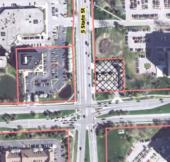
Aerial view of the site for a Shell station and drive-thru restaurant at the northeast corner of South State and East Eisenhower.
The plan calls for demolishing the current one-story convenience store and car wash on this site, which total 2,435 square feet. In its place, the owner – Joseph Kafi of JAK Cubed LLC – would put up a single building with a 1,250-square-foot drive-thru restaurant and 3,000-square-foot convenience store. The existing gas pump island canopy will remain in place, and two pumps will be relocated to spots under the canopy.
According to a staff memo, a single lane drive-thru would be primarily accessed from the existing East Eisenhower Parkway curb cut. Vehicles would move in an east-to-north direction before exiting onto either South State or looping back south to East Eisenhower. The drive-thru lane provides stacking for up to nine vehicles and would be screened to the west by the proposed new building. A total of 22 parking spaces are proposed for the site, including eight that are located at the four gas pump islands.
A new sidewalk connection with a striped crosswalk would connect the southern building entrance to the public sidewalk along Eisenhower.
Approval was needed to modify landscaping requirements in Chapter 62 of the city code – the landscape and screening ordinance. A minimum 10-foot right-of-way buffer is required. The owner is asking that the width of the buffer be reduced to the existing 4-foot wide right-of-way landscape buffer fronting South State Street, which contains a 30-inch-high screening wall and landscaping. That would allow for continued use of the two gas pump islands on the western portion of this site. Other landscaping would be added along South State Street and East Eisenhower Parkway to screen the vehicular use area. The site is zoned C3 (fringe commercial).
The project, located in Ward 4, is estimated to cost $800,000. The business is expected to remain open during construction. The existing convenience store will then be demolished after the new building is finished. The specific restaurant to be located there is still being negotiated, according to the owner.
Planning staff recommended approval of the plan. [.pdf of staff report]
Shell Station Site Plan: Public Hearing
Brad Cousino of Terratek Design Inc., the project’s engineer, began by noting that his older brother, Ken Cousino, had spoken to commissioners earlier in the meeting about a different project – the Collingwood office building site plan (see below). Cousino said he and the owners were on hand to answer any questions.
Shell Station Site Plan: Commission Discussion – Traffic, Parking
Eleanore Adenekan wondered if traffic would be congested coming in from the Eisenhower side. City planner Chris Cheng replied that the owner had submitted a traffic study. The city’s traffic engineer had commented that the site will capture drive-by traffic – that is, traffic that is already in the area. So the project isn’t expected to increase traffic significantly, he said. Within the site, there will be space for nine vehicles to queue up in the drive-thru lane.

From left: Joseph Kafi and Brad Cousino.
Sabra Briere wondered how the drive-thru would be accessible from State Street. Cheng noted that vehicles coming in from State Street would need to loop around the site. Briere observed that it seems vehicles from State would be routed across incoming traffic from Eisenhower.
Wendy Woods noted that 8 of the site’s 22 spaces are located at the gas pumps. She wondered if those gas pump spaces would be tied up when someone wanted to buy gas and eat in the restaurant and there were no other parking spaces available. Brad Cousino said that technically, the spots at the gas pumps do qualify as parking spaces. But he wouldn’t expect people to park there while getting food from the drive-thru.
Jeremy Peters asked about the pedestrian crosswalk that goes across South State Street, near the southern entrance into the Shell site. He noted that South State is a road with higher speeds. In discussions about traffic and pedestrian access, Peters said, was there any talk about that crosswalk and traffic flow? Cousino said he didn’t see that as a high-speed area, because vehicles would be slowing down at the intersection of State and Eisenhower.
Diane Giannola said she uses this gas station frequently, because it’s in her neighborhood. She suggested that the walkway should be well-marked to indicate that it’s a pedestrian crossing, so that cars entering from Eisenhower can see it. Cousino said they could put some kind of pedestrian crossing sign there.
Ken Clein noted that the parking along the proposed building gives him pause. Vehicles would be backing out into an area where other cars would be pulling into the pumps.
Bonnie Bona pointed out that there’s a six-foot space between the building and the parking spots, but that includes a two-foot overhang from vehicles – so there would only be four feet between a vehicle’s bumper and the building. She asked planning staff to verify that there’s enough space for the walkway. She assumed that the business wouldn’t be putting items like propane tanks on the walkway. The area looks really tight, she said.
Following up on Bona’s comments, Clein suggested that the project team look at the location of the entry doors to the convenience store, to make sure they are accessible from the parking area. He didn’t think it would meet ADA requirements, but noted that it’s not in the planning commission’s purview. Cousino described the plans as not yet finalized, so the issue that Clein raised would be addressed.
Bona asked how the 22-space parking minimum had been calculated. Cheng replied that it’s calculated by taking a combination of the requirements for the restaurant and for the convenience store. Bona said she supports less parking in general, so she’s not concerned about counting the eight spaces at the pumps. In the past, the planning commission has even discussed counting the stacked spaces in the drive-thru queue, she said.
Shell Station Site Plan: Commission Discussion – Canopy, Dumpsters
Sabra Briere noted that the canopy over the gas pumps, a chevron shape, is clearly designed for three sets of pumps, but there will only be two sets. Briere said she was curious about that. Chris Cheng noted that the entire canopy covers the pumps and the walkway to the convenience store.
Ken Clein clarified with Cheng that the dumpster enclosure on the site plan is proposed, but doesn’t currently exist. Jeremy Peters wondered if the enclosure would have room for a grease dumpster, in addition to trash and recycling. Brad Cousino said that the 20-foot-wide enclosure is generous, so there might be room for a grease container.
Shell Station Site Plan: Commission Discussion – Landscaping
Regarding the landscape buffer, Bonnie Bona said she’s very supportive of maintaining the existing plants, adding that she knows how difficult it is for plants to survive in those kinds of locations. She wondered if the trees there are growing. The owner, Joseph Kafi, replied that in the six years he’s had the site, the trees appear to be growing. He’s also planted a crabapple tree and shrubs, which are doing well, he said.
Shell Station Site Plan: Commission Discussion – Drive-Thru
Wendy Woods asked what kind of drive-thru restaurant would be located there. Brad Cousino said they’re negotiating with several different chains, but it hasn’t been decided.

Wendy Woods.
Jeremy Peters wondered where signs for the restaurant would be located. Cousino replied that he wasn’t sure what the sign ordinance would require, but the signs would be visible. Peters hoped that the signs for the Shell station and the restaurant would be put on the same signpost.
Sabra Briere asked if the proposal complies with the proposed changes to the city’s zoning ordinance regarding drive-thrus. Wendy Rampson noted that the proposed changes would limit the drive-thru lane in a site’s front open space, to make sure it’s well-screened. She said this project wouldn’t be affected by the proposed amendments to the ordinance. [.pdf of proposed ordinance amendments, to be considered by the commission on April 1.]
Kirk Westphal wondered whether this kind of project would require special exception use approval, if proposed amendments to the ordinance are passed. Yes, Cheng replied, but currently drive-thru uses are permitted in C3 zoning.
Westphal asked Cheng to comment on why drive-thrus are currently allowed in this zoning district. Cheng replied that the city’s master plan does recommend commercial uses for this particular corner, with pedestrian amenities. The site plan includes a pedestrian connection from Eisenhower and six bike hoops. Rampson noted that C3 is the only zoning district that now allows drive-thrus without requiring a special exception use permit. She reported that the commission’s ordinance revisions committee is interested in putting more restrictions on this type of use because it’s not in alignment with the city’s master plan objectives.
The planning commission’s April 1 agenda includes proposed revisions to the zoning ordinance related to drive-thrus. The amendments would add a definition of a “drive-thru facility” to the ordinance. Drive-thrus would need special exception use permits, which would be allowed in the O (office), C2B (business service) and C3 (fringe commercial) zoning districts. Basic layout requirements would also be added to the ordinance.
Currently, drive-thrus are allowed in C3 districts without a special exception use permit. They are allowed as special exception uses in the C2B district.
Wendy Woods said that given the site’s location near an expressway – the I-94 exchange is located just south of this intersection – she thought the drive-thru would make sense.
Outcome: Commissioners recommended approval of the site plan and landscape modifications for the Shell station project.
Collingwood Site Plan
A proposal to expand an office building at 278-280 Collingwood was reviewed by planning commissioners on March 18.

Aerial view indicating location of 278-280 Collingwood Drive.
The site plan calls for removing the existing second floor on the east side of the office building and constructing a 2,451-square-foot second floor over the entire building for office use. A new staircase will be added at the southwest corner of the building. The second floor will overhang the first floor along the front of the building and along part of the north side.
An existing curbcut on the north side of the property will be removed. The current 22 parking spaces on the site will be reduced to 17.
Planning commissioners were also asked to approve modifications to the city’s landscaping requirements for this site. Some of the required interior landscaping – the right-of-way screening and interior landscaping island – would be in the critical root zone of two landmark trees, so the owner requested permission to move the landscaping to other parts of the site. That change is supported by the city’s urban forester.
Total construction cost for this project is estimated at $300,000. The office building is located in Ward 4. Collingwood Drive is a street off of West Stadium Boulevard, just south of West Stadium’s convergence with South Maple Road. [.pdf of staff memo]
Planning staff had recommended approval of the site plan.
Collingwood Site Plan: Public Hearing
Ken Cousino spoke during the public hearing, and noted that the project’s two owners were attending the meeting as well to answer questions.

Ken Cousino.
Collingwood Site Plan: Commission Discussion
Jeremy Peters asked for clarification about the curbcut off of Collingwood. City planner Chris Cheng explained that after the staff report was written, it was determined that there was no need to actually increase the width of the curbcut to meet the current code. The curbcut had been installed in 1978, so it would be considered an existing, non-conforming curbcut and wouldn’t be changed.
Wendy Rampson, the city’s planning manager, noted that the entire area had originally been zoned for parking. It had been intended as a buffer between the commercial corridor of West Stadium Boulevard and the office district to the east. The area was rezoned from parking to office in 1965.
Peters supported removing one of the curbcuts, saying it made things easier for pedestrians. He also supported landscaping modifications so that the landmark trees would be preserved.
Bonnie Bona clarified with Cheng that the pavement currently in place for the north curbcut would be replaced with turf and landscaping.
Bona also asked if the building would require an elevator. Ken Cousino responded that it did not. Bona noted that the project is only taking about half of the allowable floor-area ratio (FAR). She said she always likes to know why a project doesn’t take full advantage of the density that’s allowed. Cousino replied that an additional floor would require that an elevator be installed.
Outcome: Commissioners unanimously recommended approval of the site plan and modifications to the city’s landscaping requirements. It will be forwarded to the city council for consideration.
Belle Tire Easement
The March 18 agenda included an easement related to a new Belle Tire at 590 W. Ellsworth.
The commission had recommended site plan approval at its Aug. 20, 2013 meeting, and the project subsequently received city council approval on Oct. 7, 2013. The site is located in Ward 4.

Aerial view of a proposed Belle Tire site.
A 50-foot-wide right-of-way easement on the front of this site was recorded by the city as part of a previously approved land division for this parcel. That easement reduced the front setback of the Belle Tire building from 10 feet to roughly 3 feet. The minimum front setback for this site, which is zoned C3 (fringe commercial), is 10 feet.
So the property owner, who also owns the adjacent site at 3975 S. State, has proposed that the city vacate the northern 7 feet of its right-of-way easement. In exchange, the property owner has offered to convey a non-motorized use easement over the same 7 feet.
Such an easement would allow for this strip to be used by the public for future non-motorized transportation facilities, according to a staff memo. And as a non-motorized use easement, the 7-foot strip would be considered part of the required 10-foot front building setback.
The planning staff recommended approval of this proposal. No one spoke during the public hearing.
Belle Tire Easement: Commission Discussion
Ken Clein asked whether the intent is to have a future pedestrian pathway on the easement. Planner Chris Cheng, who gave the staff presentation, said there are no current plans other than the sidewalk that will be installed as part of the site plan. But if in the future there are road improvements on Ellsworth and the sidewalk must be removed, then a sidewalk or other non-motorized use could be located in the easement.
In response to another query from Clein, Cheng noted that the site plan addresses a grade change along that edge of the property by including a walkway and some steps.
Outcome: Commissioners unanimously recommended approval of this proposal. It will be forwarded to the city council for consideration.
Communications & Commentary
Every meeting includes several opportunities for communications from planning staff and commissioners, as well as two opportunities for public commentary. No one spoke during public commentary on March 18.
Communications & Commentary: Planning Commission Bylaws
Planning manager Wendy Rampson noted that the city council had approved some revisions to the planning commission’s bylaws – but not all of the revisions that have been recommended by planning commissioners were brought forward. The council approved the revisions that planning commissioners had passed about six months ago – at its July 16, 2013 meeting.
The changes relate to the order of agenda items, and the length of time required for special accommodations. The bylaws, as revised, call for additional lead time so that special accommodations, including a sign language interpreter, can be made for people with disabilities, when requested at least two business days in advance of a meeting. The previous bylaws specified just a one-day advance request.
Revisions that were approved by planning commissioners more recently – at their Feb. 20, 2014 meeting – have not yet been forwarded to the council. Rampson reported that assistant city attorney Kevin McDonald wanted to have some additional discussion about those revisions related to public hearings.
Wendy Woods wondered whether the city attorney’s office would work quickly, “so that we aren’t waiting a long time.” Rampson replied that she asked McDonald to draft language that he would find acceptable, and that could be forwarded to the commissioners for consideration. She said she’d communicate with him that commissioners would like to see that as quickly as possible.
One revision clarifies the limitations on a city councilmember’s interaction with the commission. The revised section states: “A member of the City Council shall not be heard before the Commission during the Councilmember’s term in office.” The intent is to prevent undue influence on the commission, and to avoid the possibility of legal action against the city.
Other revisions affect speaking turns at public hearings. The intent is to clarify how many turns the same person can speak at a public hearing, and how public hearings are continued if an item is postponed.
Present: Eleanore Adenekan, Bonnie Bona, Sabra Briere, Ken Clein, Diane Giannola, Jeremy Peters, Paras Parekh, Kirk Westphal, Wendy Woods. Also: City planning manager Wendy Rampson.
Next meeting: Tuesday, April 1, 2014 at 7 p.m. in the second floor council chambers at city hall, 301 E. Huron St., Ann Arbor. [Check Chronicle event listings to confirm date]
The Chronicle survives in part through regular voluntary subscriptions to support our coverage of publicly-funded entities like the city’s planning commission. If you’re already supporting The Chronicle, please encourage your friends, neighbors and coworkers to do the same. Click this link for details: Subscribe to The Chronicle.
“…that conditions the sale of the property in order to obtain a long-term, ongoing and growing economic benefit for the residents of the city;…”
This tells us all we need to know about the goals and direction of our current planning commission. Money and buildings first, people second. Ms. Bona and Ms. Giannola characterized the CWS plan as having lots of public input; the little public input that was gathered asked for more downtown parks and open space, not iconic, maximum density buildings. Ms. Briere suggests that a public use is not a “strong frontage” – the implication being that private use is stronger than public use? The notion put forth by Mr. Clein, Ms. Bona, and Ms. Briere that …”the ultimate test is whether the outcome is what the community wants…” I find that rather disturbing, are they suggesting that the outcome be decided by developers, in the hopes that the community approves of whatever mixed-use, cookie cutter project gets built on this site? And if it is not what the community wants, what then?
What is planning for, if not to make the best effort to achieve the goals of a community though legitimate public input and thoughtful, informed policy-making? I know some are in a panic to see every remaining square foot of the DDA district built up as quickly as possible, but I can assure them, this is a minority view.
Re #1. Mr. Hayner misinterprets the recommendation for a ‘strong frontage.’ A strong frontage includes a street-wall or entrance directly from the sidewalk into the building. In design manuals, it’s a recommended element of urban (or downtown) design. That design goal is not compatible with having a soft (open, green, park-like) frontage – which is what the Council proposed. And what I supported.
It has nothing to do with who owns (and/or maintains) the park – it has to do with the building design.
In conversation with City staff and parks supporters, I’ve recommended that the community – not the developer – should determine the use and design elements of the public space. A public, thoughtful process would be the best outcome for all – including any possible developer.