Council Gets Advice on Y Lot Development
Ann Arbor planning commission meeting (Aug. 20, 2013): As the city council considers selling the former Y site at 350 S. Fifth, planning commissioners have outlined the kind of development they’d like to see at that location.
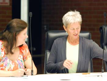
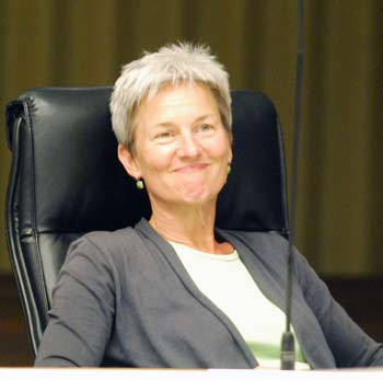
Ann Arbor planning commissioners Diane Giannola and Bonnie Bona drafted a resolution with recommendations to the city council regarding development of the former Y lot, which is owned by the city. (Photos by the writer.)
The commission voted unanimously to recommend that the council, if it decides to proceed with a sale, should use a request for qualifications (RFQ) and request for proposals (RFP) process.
The planning commission is also recommending that the council impose a set of conditions for future development. The list includes mixed-use development that encourages foot traffic and active first-floor uses, an entry plaza or open space, and mandatory compliance with the city’s design guidelines.
The site was one of five parcels that was the focus of the Ann Arbor Downtown Development Authority’s Connecting William Street project. Much of the Aug. 20 discussion centered on the use of CWS as a framework for the resolution.
Sabra Briere, who serves as the city council’s representative to the planning commission, suggested removing entirely references to the CWS project. The council never adopted the CWS report or took any action to implement the CWS recommendations, she noted. Briere felt that leaving those references to CWS in the commission’s resolution might make some councilmembers more resistant to it.
Wendy Woods, a former councilmember, countered that “our role is not to give pablum to council.” The commission’s role is to give advice as a body, regardless of how it might be received by the council, Woods said. She also pointed out that it’s not necessarily Briere’s role to advocate for positions taken by the commission. “The planning commission is its own advocate and we stand on our own,” Woods said.
Bonnie Bona and Diane Giannola, who drafted the resolution, pointed to the amount of public input that had been solicited during the CWS process, and felt that it was more powerful for the commission’s recommendations to be supported by that input. Giannola didn’t want to get into the politics of guessing what the council might support, but offered to extract references to CWS from the two resolved clauses. That compromise was acceptable to Briere and the other commissioners. [.pdf of amended Y lot resolution]
During the discussion, Briere also reported that the broker hired by the city to handle a possible sale has been meeting with councilmembers to talk about the Y lot. The broker is likely to suggest putting as few stipulations on the property as possible, she said, because he believes that such stipulations will lower the purchase price. That’s not necessarily what all councilmembers believe, she noted, but it’s what they’re being told.
The commission’s resolution will be forwarded to the city council as an item of communication, and will possibly appear on the agenda as soon as Sept. 3.
In other action, commissioners recommended approval of a two-story addition that more than doubles the size of the Honda vehicle testing facility on Ann Arbor’s south side. The existing 19,357-square-foot building, built in 1975, is located at 3947 Research Park Drive on a 2.72-acre site. During a public hearing on the project, a representative of American Honda Motor Co. reported that the expansion will include a state-of-the-art environmental testing chamber, to help Honda develop vehicles with cleaner fuel emissions. The $4.3 million project is expected to increase the number of employees who work at the site from 6 to 10.
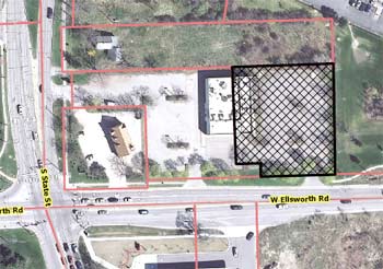
Commissioners also recommended approval of (1) the site plan for a proposed Belle Tire at 590 W. Ellsworth – just east of the intersection with South State Street, and (2) an annexation and zoning request for 2640 Miller Road, on the city’s northwest side.
Recommendation for Y Lot
The idea for developing recommendations for the former YMCA lot’s future was first proposed by commissioner Bonnie Bona, and initially discussed at a July 9, 2013 working session. [See Chronicle coverage: "Planning Group Strategizes on Downtown."] Several commissioners subsequently discussed a draft version of the resolution – developed by Bona and commissioner Diane Giannola – at another working session on Aug. 13. [.pdf of original planning commission resolution, before amendments]
The city acquired the former Y site in 2003. It’s located at 350 S. Fifth, across from the downtown Ann Arbor District Library and south of Blake Transit Center. The city council is now exploring whether to sell that property. Earlier this year, the city selected Colliers International and local broker Jim Chaconas to handle the possible sale, as the city faces a $3.5 million balloon payment this year from the purchase loan it holds on that property.
Now a surface parking lot, the site was zoned D1 as part of the original A2D2 (Ann Arbor Discovering Downtown) zoning process. The site was also one of five parcels that was the focus of the Ann Arbor Downtown Development Authority’s Connecting William Street project.
The original resolution recommended that the sale of the lot should use a request for qualifications (RFQ) and request for proposals (RFP) process. It recommended that the city council require some or all of these conditions:
- A building that generates foot traffic, provides a human scale at the ground floor and creates visual appeal per the Connecting William Street Framework Plan;
- A “mixed use” development per the Connecting William Street Framework Plan;
- Any vehicular access and parking be accessed via the City’s Fifth Avenue underground parking structure;
- An entry plaza or open space appropriately scaled and located to be properly activated by adjacent building uses and to be maintained by the developer;
- The entry plaza or open space to incorporate generous landscaping;
- Mandatory adherence to the Design Guidelines as interpreted by the Design Review Board;
- A third party certification for the building’s energy and environmental performance (e.g. LEED Gold or LEED Platinum).
The goal, according to the resolution, is “to obtain a long-term, ongoing and growing economic benefit for the residents of the city.”
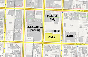
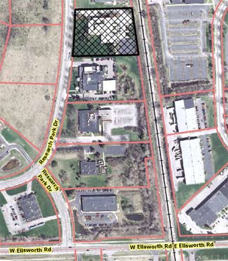
Highlighted in yellow is the location of the former YMCA lot, which the city of Ann Arbor is considering selling. A $3.5 million balloon payment on the property is due at the end of 2013.
Recommendation for Y Lot: Public Commentary
Don Salberg was the only person who spoke on this topic. Prior to the commission’s discussion, he asked if commissioners could provide a clear definition of the recommendations. For example, how would they define “increased foot traffic” and what is specifically meant by “mixed use.” This would help people understand what’s intended for development on the site, he said.
Also, he told commissioners that many people feel the survey taken as part of the Connecting William Street report was not done properly and did not reflect the viewpoints of the majority of residents in Ann Arbor. He felt the city shouldn’t try to sell its property until it’s clear what would be built on it. These properties are revenue-producing, he said. [Four of the five lots in the CWS study are surface parking lots. The fifth site is the parking structure at Fourth & William.] The Y lot brings in $248,000 annually, he said, which he believes would be enough to service a $3.5 million, 25-year loan if the city can get it for around 3%. “I don’t see why there’s such an urgency in trying to sell this property,” he said.
Recommendation for Y Lot: Commission Discussion
Bonnie Bona began the discussion by describing the history of the site, and listing several factors that prompted this resolution. It’s in a D1 zoning district, and the city has asked the planning commission to review D1 zoning. [See Chronicle coverage: "Priorities Emerge in Downtown Zoning Review."] It was one of five city-owned lots that were part of the Connecting William Street project, which had included a lot of public input, Bona noted. That CWS project, conducted by the Ann Arbor Downtown Development Authority, was done after the site had been zoned D1. The city’s climate action plan was also developed after the Y lot was zoned D1, she said.
There are a few things from these initiatives that she and some other planning commissioners felt should be incorporated into the sale of a city-owned property, Bona said, as additional requirements for such a sale.
Bona then read the “whereas” clause that she felt was the most important one in the resolution:
WHEREAS, the redevelopment of city-owned parcels are the City’s only opportunity to require a development with greater emphasis on long-term, ongoing and growing economic benefit to the community;
That clause captures the biggest point that Bona wanted to make – the sale of a city-owned property could make a larger contribution to the community.
Sabra Briere addressed the questions asked by Don Salberg during public commentary, related to the meanings of foot traffic and mixed use. As city staff and planning officials use the term, “mixed use” refers to development that is more than a single use, she said – not just housing or offices, for example, but a combination of uses. It might be retail, office and residential. Mixed use is not a building that simply includes parking for residential, she added – because if that parking for residents of that building, it’s not public parking and not considered a separate use.
Generating foot traffic is a goal that many people in the community have talked about for the Y lot and other sites, Briere continued. They want a reason to go to the building, which tends to mean retail or restaurants, she added, but not a bank or other business that doesn’t generate a lot of foot traffic.
The rationale for encouraging mixed use and foot traffic is that people want a reason to be downtown – things to go to and places to see, Briere said, and that’s a positive for the rest of the community.
As far as why the property is being considered for sale, Briere said that the council has been hearing from at least one councilmember for the past five years that the city should be selling this property rather than paying interest on the loan. [She was referring to councilmember Stephen Kunselman (Ward 3).] Earlier this year, the council agreed to put any net proceeds from the sale into the city’s affordable housing trust fund, she noted. Because of that, there’s a desire to achieve as much revenue as possible from the property.
Paras Parekh asked about one of the “whereas” clauses:
WHEREAS, the Connecting William Street Framework Plan contains recommendations that focus on bringing people and activities to this and other core downtown sites to achieve the common goals expressed by the community: creating the interesting and engaging sidewalk atmosphere currently lacking along William Street and recommends a large plate office or lodging as a primary use, residential as a secondary use and active uses on the first floor; (To achieve this the recommendations seek to encourage uses that generate foot traffic, provide a human scale at the ground floor, create visual appeal, and provide an interesting and pleasant overall experience.);
To Parekh, it read that the commission prefers large plate office or lodging, and that secondarily, residential is acceptable. Is that the intent? Bona replied that that the clause states verbatim what’s in the Connecting William Street plan. In creating the plan, the DDA had worked with a land use economist, Todd Poole, who helped identify what kind of use would be marketable, she said.
Typically, Bona said, the city doesn’t have a lot of say about the kinds of uses that are included on a property. In the downtown, the mix of uses is what’s most important, she said. So the resolution is recommending to council that the city require mixed use on the Y lot, and citing the CWS recommendations as examples of the type of mixed use that might be encouraged.
Later in the discussion, Bona clarified that this “whereas” clause included elements from the CWS report that are important. The Y site is one of the few lots downtown that could handle a large plate office, she said. As an example, a large tenant like Google would prefer not to be on three floors, as they currently are, Bona said. Large tenants that want to locate their operations on a single floor can’t find those conditions downtown, and that’s why the reference to large plate office as a primary use is in the CWS report. Public input indicated that this was an acceptable use, she said. Bona noted that the “resolved” clauses are not as specific as the “whereas” clauses, and simply recommend mixed use.
Parekh suggested combining the two “resolved” clauses, and there was some discussion about that. He said that because he was new member to the commission, he’d defer to other commissioners. Diane Giannola responded by saying that a resolution of this kind is “a rare event” for the planning commission, so there’s no typical way of doing it. She had separated the two “resolved” clauses because she thought they were two separate recommendations: (1) to use a request for qualifications (RFQ) and request for proposals (RFP) process; and (2) to include a set of conditions in the RFQ/RFP. That way, the council could act on either of the recommendations, or both.
Wendy Woods wondered what an RFQ entailed, and whether the recommendations needed to include both the RFQ and RFP processes. Bona explained that an RFQ is a request to get information from potential developers before they do any work on a proposal. From that, you select a short list of developers and ask them to do a proposal. It’s extremely time-consuming to do a proposal for a project like this, Bona said, and it’s more fair to pre-select developers rather than to make a wide open RFP. She thought that an RFQ was a critical element in soliciting good proposals. She noted that the RFQ/RFP phrasing was consistent with the CWS recommendations.
Woods said she found it confusing, but it wasn’t a deal-breaker for her. She felt the resolution ran the risk of guiding everything toward the CWS plan, and she didn’t think the commission wanted to do that. She noted that the commission had accepted the CWS plan and sent it to the council, but she wasn’t sure what council had done with it. [At its March 5, 2013 meeting, the commission unanimously voted to add the CWS plan to the list of resource documents that support the city’s master plan. The council has taken no action regarding the plan.]
Woods then pointed to the phrase “the Y Lot should be sold …” in both of the “resolved” clauses. Some people in the community might not be sure that the lot should be sold at this point, she said. She suggested replacing it with “the Y Lot, if sold …” Otherwise, it would seem like the planning commission thinks the lot should be sold, Woods contended. “I don’t think that we’ve had that discussion. I think we’re just really trying to respond to what city council is doing.”
Giannola and Bona indicated that the “if sold” change was considered as a friendly amendment.
Briere thanked Bona and Giannola for their work, but said she was still concerned about the reliance on the Connecting William Street framework. The council didn’t accept it or direct the planning commission to implement it, she noted. The original expectation had been that the council would task the planning commission with adding the CWS recommendations into the master plan, but that hadn’t happened. To her, it means that the council “wasn’t as enthusiastic as maybe people would have wanted it to be, about the results of the Connecting William Street framework plan and process.”
She didn’t think it was necessary, from an organizational standpoint, to rely on the CWS framework to support the commission’s resolution. “I think it’s likely to turn some members of council away from reading it and understanding the purpose.” That’s a problem, since that could prevent some councilmembers from paying attention to the underlying message of the resolution.
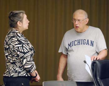
Sabra Briere, who serves on both the city council and planning commission, talks with Ann Arbor resident Don Salberg before the start of the commission’s Aug. 20 meeting.
Briere reported that the broker hired by the city is suggesting that the council put as few stipulations on the land sale as possible. The broker isn’t suggesting that there’s a lot of revenue to be gained from this land sale, and the more restrictions that are placed on the property’s use and appearance, the more difficult it will be to generate sufficient revenue to cover the debt and add to the affordable housing trust fund, Briere said.
This isn’t necessarily what the council believes, Briere added, but that’s the message that councilmembers are receiving from the broker.
In conversations with some of the other councilmembers about the Y lot, Briere said, they seem to feel strongly that there should be a mixed use development there. Having parking built on the site for residential use should entail connecting to the existing underground parking structure via a connection under Fifth Avenue – that’s both frugal and sensible, she said. Some councilmembers really want open space on the Y lot, while others might have heard the message that requiring open space would mean lower revenue from the sale, she reported
The proposed resolution might not generate support on the city council as it’s currently written, Briere said. She’s the planning commissioner who sits on council and really ought to be advocating for this resolution, Briere added. “Otherwise, if I can’t advocate for it, I think it’s harder for it to pass.” So she was concerned about voting on it as written, saying she’d like to “whittle away” references to Connecting William Street that aren’t as helpful as she’d like them to be. She’d also prefer to keep the resolution shorter – preferably one page. Such revisions “won’t make anyone immediately resistant to it when they read it, but they’ll actually pay attention to the recommendations,” she said.
The recommendations as a whole follow the master plan documents regarding the downtown, Briere said, and don’t need the Connecting William Street plan to back them up. “I would hate to have resistance just because [councilmembers] see words that make them unhappy,” she concluded.
Woods responded, saying she was trying to give her remarks in the most respectful way that she could. The planning commission’s role is to give advice, she said. “Forgive me how I say this, but our role is not to give pablum to council. And sometimes they’re going to hear things that they perhaps don’t agree with, and then it’s up to them to do with it what they will.”
When Woods served on council, she recalled, there was a period when she also served on the planning commission. There were certainly times when she didn’t agree with the outcome of planning commission decisions, but she hadn’t seen her role as an advocate for the planning commission. “The planning commission is its own advocate, and we stand on our own.” She didn’t want Briere to feel that it’s her responsibility to take something from the planning commission and get it passed by council.
Bona called attention to the fact that both “resolved” clauses include the words “recommend.” The resolution also states that the role of the planning commission is to advise the council on development issues, she noted. The commission would be ducking its responsibility to avoid something that council might find controversial, she said. “I think we would be actually doing a disservice if we do that.”
As far as Connecting William Street, Bona thought that the controversy surrounding the Library Lane site “shouldn’t take down the whole document.” Relative to the Library Lane site, the Y lot was not controversial, she noted, adding that “someone has to have the backbone to make a decision, at some point.” [Some residents – including members of the Library Green Conservancy – have advocated for turning the Library Lane site into a public plaza or park, rather than developing it.]
Many of the recommendations in the resolution are reinforced by the Connecting William Street report and the public input it entailed, Bona said. The public indicated support for mixed use and open space on the Y site, she noted, which are both recommendations in the resolution. So she thought it was important to reference the CWS report. “I don’t want to shy away from that public input, just because a few of people don’t like a couple aspects of the document.”
Bona also felt that most of the recommendations will ultimately enhance the value of the site. “I don’t care what that broker told you,” she said, referencing Briere’s comments. “I think that [adding conditions] will actually increase the value of that property – they just may not know it.”
Kirk Westphal reviewed some of the history of the Y site, going back to the council’s directive to the DDA that launched the Connecting William Street study. The DDA was tasked with creating a plan for development of the five city-owned sites, he said, and not to create a new open space plan – saying the open space plan had been taken care of by the park advisory commission and parks staff. The city’s parks and recreation open space (PROS) plan had been updated recently, he noted, giving a very low priority for new downtown open spaces. Nor is downtown open space a priority in the master plan documents, he said.
During the Connecting William Street process, Westphal said, a renewed interest in downtown open space emerged. That’s actively being addressed by the park advisory commission, he added, and he hoped that’s why the council put the CWS plan on hold, to wait for that process to finish. Westphal noted that he had served on the advisory committee for Connecting William Street, and it had included the a great number of unique contact points in the community, to get input. It was a robust discussion, he said, and the Y lot had been one of the least controversial sites.
The plan had provided clear overarching recommendations, as well as specific recommendations for each site, Westphal noted. It also provided flexibility for development. It wasn’t intended for the city to issue an RFQ or RFP for someone to develop all five sites at the same time, Westphal stressed. Rather, a phasing approach is recommended, he said.
The community, via input during the Connecting William Street study, had clearly indicated support for better materials and architecture, a plaza or other amenities in exchange for a lower selling price, Westphal said. And there’s a lot of research showing that even if the city gets a lower sale price because of these conditions, a higher quality building will result in higher taxable income over the long term, he said.
Giannola felt that the Connecting William Street plan was the only available public input on the Y lot. It looks like the council wants to sell that site, she added, so if planning commissioners want to make recommendations, that’s the only public input they can point to. The master plan isn’t as specific, and she thinks it’s more powerful to have the public input backing up the commission’s recommendations.
As a compromise, Giannola suggested leaving references to Connecting William Street in the “whereas” clauses, but taking out those references in the “resolved” clauses.
As for how council might react to the resolution, Giannola said she completely agreed with Woods. “I don’t think we should assume or pre-judge what council’s going to do. This is supposed to represent our thinking. So I don’t really want to get into the politics of it all.” Commissioners should just look at this resolution and decide whether they believe what’s stated in it, she said.
Briere said she appreciated the comments of Woods, Bona and Giannola. They were right about the planning commission’s role as making recommendations to council.
Briere has heard concerns about the fact that the council felt like “less than the final authority” on the external design of 413 E. Huron, a recent controversial development at the corner of Division and Huron. But that was private property, she noted. The Y lot is public property. She said it could be very valuable to the community to have a serious impact on the external design on a very prominent building on the Y site, located on one of the few vacant corners that’s fronting three streets.
Briere supported the suggestion of removing references to Connecting William Street from the “resolved” clauses.
Jeremy Peters agreed that the resolved clauses need to state strongly that the commission wants to see some or all of the listed conditions in a project for that site. “I think we’d all agree that the plain by-right zoning is just not what we – nor the rest of the community – would want to see on that lot, if council decides to move ahead and sell it.”
The remainder of the discussion resulted in some additional friendly amendments to the original resolution. Highlights from amendments to the resolved clauses included eliminating references to Connecting William Street; adding the phrase “if sold”; and connecting parking on the Y lot with the existing stub in the Fifth Avenue underground parking structure. [.pdf of final Y lot resolution]
Outcome: Commissioners voted unanimously voted to approve the Y lot resolution, as amended. It will be forwarded to the city council as an item of communication. That communication item might appear on the council’s agenda as early as Sept. 3.
After the vote, Bonnie Bona asked city planner Matt Kowalski to explain what happens next in this process. Kowalski said that a copy of the resolution will likely be placed on the council’s Sept. 3 agenda.
Sabra Briere clarified that it won’t be an action item for council, and wouldn’t entail a public hearing. It would be placed on the agenda as an item of communication. When the council is ready to take its next step regarding the Y lot, then it would be appropriate for the resolution to become part of that action. She recommended that a copy of the resolution be sent to the city administrator, Steve Powers, with a request that he forward the resolution to the broker.
Kirk Westphal expressed some concern that the resolution, as an item of communication, won’t spur discussion or attention. Wendy Woods noted that there are other ways for citizens, including planning commissioners, to bring items to the council’s attention. People can individually contact councilmembers, for example, or speak during public commentary.
Recommendation for Y Lot: Final Public Commentary
At the end of the meeting, Don Salberg spoke again about the Y lot resolution. He calculated that the parking lot at Fifth and William is about 70% occupied, on average. He understood that the intent of Connecting William Street was to eliminate the surface parking lots. He knows many people who disagree with that, however, and he himself uses those lots and finds them convenient. Being forced into parking structures would be inconvenient, he said.
Salberg noted that there was sufficient parking in the Fifth Avenue underground parking structure, and concluded that people parking on the surface lot at Fifth and William could use the underground structure. Why don’t they? he asked. Someone should stand at the gate and ask people why they’re choosing to park on the surface lot rather than the Library Lane structure. The Y site isn’t being wasted, he said. It generates parking revenue that could cover the cost of the loan, Salberg contended, so the city could wait until there’s actually a need for building.
No one can name a company that would occupy an office built on the Y lot, he said. Salberg cited the example of Costco, which built its store at Ellsworth near South State specifically for its own use. That’s different than a development that’s speculative. Buildings like Ashley Terrace have failed, he contended, because they were speculative and can’t find tenants.
Honda Test Facility Expansion
An addition that more than doubles the size of the Honda testing facility on Ann Arbor’s south side was on the planning commission’s Aug. 20 agenda.
The existing 19,357-square-foot building, built in 1975 and used for vehicle testing, is located at 3947 Research Park Drive on a 2.72-acre site, adjacent to railroad tracks to the east. The proposal calls for building a two-story, 24,116-square-foot addition. Part of that square footage includes a partial basement level.
The project would also entail removing a fence from a parking area in the back that has 26 parking spaces. The fence would be replaced with 10-foot-high privacy panels. Four bike hoops would be installed in front of the building, with additional bike spaces inside. There is no stormwater treatment on site, so the project includes building a below-grade infiltration system with a connection to the city storm sewer. One footing drain disconnect will be required, as part of the city’s footing drain disconnect program. That part of the project will be handled by CDM Smith, according to a staff memo.
Two of the site’s seven landmark trees would be removed, and mitigated by planting six new trees. In addition, 32 shrubs will be planted in front of the new addition. A 5-foot public sidewalk will also be built along Research Park Drive.
The site is zoned RE (research district) and no rezoning is requested. The expansion will increase the number of American Honda Motor Co. employees who work at the site from 6 to 10, according to the planning staff.
The project is being managed by Poggemeyer Design Group in Bowling Green, Ohio. The estimated construction cost is $4.3 million. A variance related to the size of the existing curb cut will be needed from the city’s zoning board of appeals, which will consider the item at its Aug. 28 meeting. The driveway width now is about 19 feet, smaller than the city’s required 24 feet for a two-way drive. After consulting with the city’s engineering and traffic staff, the planning staff supports this variance because the traffic at the site is relatively low.
The site is located in Ward 4.
Honda Test Facility Expansion: Public Hearing
Only one person spoke during a public hearing on the project. Tommy Chang, representative of American Honda Motor Co., told commissioners that he was there with three members of the expansion project team who were on hand to answer questions. They are very excited that the company has decided to invest in the Ann Arbor lab. The facility opened in 1975 to conduct tail-pipe emission testing and fuel economy testing, in compliance with regulations of the U.S. Environmental Protection Agency (EPA). He reported that the expansion will include a state-of-the-art environmental testing chamber, to help Honda develop vehicles with cleaner fuel emissions.
Chang thanked city planner Matt Kowalski for his help, and said the intent of the project is also to bring more jobs to Ann Arbor from Japan. Personally, he said, Ann Arbor is the right place for this investment. [Chang also attended the city council meeting the day before and was introduced before the meeting to city administrator Steve Powers by Sally Petersen (Ward 2).]
Honda Test Facility Expansion: Commission Discussion
Wendy Woods asked about the sidewalk, wondering if it would be connected to existing sidewalks – or would it be the first in that area? City planner Matt Kowalski replied that it would connect to a sidewalk on the south, but there’s no existing sidewalk on property to the north. When site plans are submitted, the planning staff is asking that sidewalks be included.
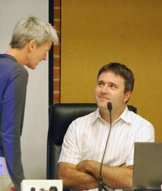
Planning commissioner Bonnie Bona talks with city planner Matt Kowalski prior to the Aug. 20, 2013 planning commission meeting.
Woods wondered if most of the businesses in that area are related to the auto industry. There are several auto research operations in the Research Park area, Kowalski replied, including a Mercedes facility adjacent to Honda. Woods joked that the firms are in competition for consumer dollars, so maybe they could impress the city by putting in sidewalks.
Jeremy Peters asked if Honda had included natural screening as an option, instead of fencing or panels around the back parking lot.
A member of the Honda design team said the purpose of the panels isn’t simply to protect vehicles from “prying eyes,” but is also intended for security purposes. That’s why a natural area wouldn’t work, he said, adding that there have been problems in the past with people breaking into cars.
Paras Parekh asked for more details about the curb cut variance. Kowalski indicated that Honda is willing to widen the driveway, but it would add to the site’s impervious surface and eliminate two mature trees. Given the volume of traffic at the site, the city staff didn’t believe it was necessary to widen the driveway. The current curb cut was installed when the original building was constructed in the 1970s, and the need for a variance is triggered because it’s part of the current site plan.
Bonnie Bona noted that the expansion doubles the floor space, and increases the floor-area ratio (FAR) from 16% to 37%. She pointed out that prior to the city’s revisions in area, height and placement regulations a few years ago, this would not have been possible. She noted that especially in research parks, “we were getting a lot of lawn area.” The need for buffering is not as important between research facilities, Bona said, and that’s why the ordinance was changed. She wanted to highlight that because it’s one of the few projects that has taken advantage of the ordinance change since it was passed. “It’s a step in the right direction,” she said.
Bona also observed that a chart included in the staff report for this project indicates there is no height requirement. She noted that if the building were adjacent to a residential neighborhood, there would be a height requirement. Bona said she wanted to clarify that, in light of recent controversy over downtown development, related to height. She added that the limit on floor-area ratio would prevent any structure from being very tall.
Outcome: The site plan for the Honda expansion was unanimously approved, contingent on securing a curb cut variance from the zoning board of appeals. The project will be forwarded to city council for consideration.
Belle Tire on Ellsworth
The site plan for a proposed Belle Tire at 590 W. Ellsworth – just east of the intersection with South State Street – was on the Aug. 20 agenda.
The 1-acre site – currently vacant – is on the north side of Ellsworth, adjacent to and east of a new Tim Hortons. A restaurant building formerly located on the property was demolished.
The proposal calls for putting up a one-story, 9,735-square-foot auto service facility with a minimum of 49 parking spaces, included 10 spaces located in service bays. An existing curb cut into the site from Ellsworth would be closed, and the business would share an entrance with the Tim Hortons site. The project includes a new sidewalk along Ellsworth, completing a gap between the adjacent parcels. There will be a landscape buffer between the parking and sidewalk.
Approval would be contingent on securing a shared parking easement with the adjoining property to the west, and for a sanitary sewer easement to the east, that would be dedicated to the city for the sewer main.
The site, located in Ward 4, is zoned C3 (fringe commercial) and no rezoning is requested. According to a staff memo, the estimated cost of construction is $1.1 million. The project is being handled by Christopher Enright Architects of Birmingham, Mich.
No one spoke at a public hearing on the project.
Belle Tire on Ellsworth: Commission Discussion
Sabra Briere recalled that a previous project in that area, which the planning commission reviewed earlier this year, was not able to secure access to Ellsworth. [Called the State Street Center, that project is located on a thin strip of land off of South State, just north of Ellsworth and adjacent to the new Tim Hortons. At their April 2, 2013 meeting, commissioners recommended approval of the site plan and for rezoning the parcel to C3 (fringe commercial). A Jimmy John’s will face South State. A separate one-story retail building will be located behind the restaurant. At the time, the owners of the two properties could not agree on terms for creating a driveway connection between the sites.]
Briere noted that planning commissioners had been concerned about that lack of connection from South State to Ellsworth, and she wondered if there had been any change.
Katy Ryan, an intern with the planning staff who gave the staff report on this project, replied that the two parties have now agreed to create a connection for vehicles.
Bonnie Bona asked whether the owners have shared any details about that connection, including whether there will be a pedestrian component to it. “I’m just having a hard time seeing where they’ll put it,” she said. Ryan replied that the only thing city staff has been told is that there are ongoing discussions.
Christopher Enright, a Birmingham, Mich. architect who’s overseeing the project, was the only representative on hand at the meeting. He reported that there have been discussions with the owner of the property to the north of the Belle Tire site regarding several issues. The main one has been about the utility connection, he said. However, the owners also understand there are benefits to having a vehicle connection, but “it hasn’t been clearly formulated yet.” It would potentially eliminate a couple of parking spaces on the Belle Tire site, and that’s the issue they’re sorting through now, he said, because it would affect the minimum number of spaces required by the city.
Bona said she favored the connection over parking, but noted that “I don’t have that power” to waive the requirements. She hoped the sites could offer a pedestrian connection, at a minimum.
Saying that she’s normally in favor of fewer curb cuts, Wendy Woods asked for more explanation about how the new single curb cut on Ellsworth will affect traffic flow. Ryan replied that the city’s traffic engineer, Pat Cawley, has signed off on the plan.
City planner Matt Kowalski added that when a land division had previously been approved for that parcel, it had included an understanding that only one curb cut would be used when the parcels were developed. So the single new curb cut was “sized appropriately,” he said, and placed in the center of the parcels to allow for two-way traffic from both sites. There will eventually be a drive so that traffic can also exit onto South State, he noted.
Outcome: Commissioners unanimously voted to recommend approval of the Belle Tire site plan. The recommendation will be forwarded to the city council for consideration.
Land Annex on Miller Road
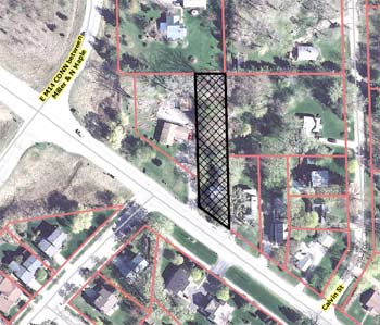
Ann Arbor planning commissioners were asked to recommend approval of an annexation and zoning request for 2640 Miller Road, on the city’s northwest side.
Owned by Robert Rayer, the 0.39-acre is located in Scio Township, on the north side of Miller west of North Maple. The requested zoning is R1B (single-family dwelling district). Properties on the east and west sides of this lot – including a site with a daycare center – are already zoned R1B.
A single-family home is on the property. According to a staff memo, the annexation was prompted because the site’s existing septic system has failed and the owners need to connect to city services. The 2013 improvement charges are $19,062, but the charges would be set whenever the city water and sewer mains are connected and the services become active.
If the annexation is approved, the site would be located in Ward 5.
No one spoke during a public hearing on this item.
Land Annex on Miller Road: Commission Discussion
Discussion was brief. Sabra Briere asked about a development that the commission had previously approved in this area – she didn’t remember the exact location of that.
City planner Matt Kowalski described the most recent project in that area as a residential development near the northwest corner of Miller and Maple, with two apartment buildings and a cluster of single-family homes that backed up to Calvin Street. [That development, Maple Cove, was recommended for approval by the planning commission on June 5, 2012. It was subsequently approved by the city council on July 16, 2012.]
Outcome: Commissioners unanimously recommended approval of annexation and zoning for 2640 Miller Road. The request will be forwarded to the city council for consideration.
Communications & Commentary
During the meeting there were several opportunities for communications from staff and commissioners, as well as two general public commentary times. Here are some highlights.
Communications & Commentary: Non-Motorized Transportation Plan
Kathy Griswold spoke to commissioners about the city’s non-motorized transportation plan. She noted that the commission’s master plan revisions committee had recently been briefed on the plan’s update. She asked that planning commissioners not accept the update, which is in the form of an appendix to the original plan. She’d like to see the plan posted online, with all of the updates rolled into it – not listed separately.
Griswold also recommended that the city review the process of how non-motorized transportation information is collected, and how it rises to the level of the planning commission and the city council for funding purposes. “People say that information is power, but so is a lack of information,” she said. There’s a huge backlog of infrastructure that’s needed, Griswold added. One example is improvements to sidewalks and crosswalks in the public school “walk zones.” This information isn’t recorded anywhere, she said, so when proposals come before the council – such as the recent bike share program – councilmembers can’t make intelligent decisions because they don’t have all the information they need.
The process for collecting this kind of information is a closed process, Griswold contended. There’s an alternative transportation committee, but she characterized it as an invitation-only group, with meetings held in the offices of the Ann Arbor Downtown Development Authority. She’d like to see some kind of open committee, with representation from the Ann Arbor Public Schools, “so that these needs can percolate up.”
Griswold reported that Craig Hupy, the city’s public services area administrator, is collecting information about sidewalk gaps, but that seems to be in isolation of the work being done by Eli Cooper, the city’s transportation program manager, she said. She’d like to have all this information in one place online.
A public hearing on the non-motorized transportation plan update is set for the planning commission’s next meeting on Sept. 10.
Communications & Commentary: North Main Huron River Corridor Task Force
Bonnie Bona, who has served as the planning commission’s representative on the North Main Huron River corridor task force, reported that the group held its last meeting earlier this month. Final touches are being put on the report, which will be delivered to the city council in September. She said the task force looks forward to having the council approve the report, and give direction about how to move forward with the recommendations.
Present: Bonnie Bona, Sabra Briere, Diane Giannola, Jeremy Peters, Kirk Westphal, Wendy Woods, Paras Parekh. Also: City planner Matt Kowalski.
Absent: Eleanore Adenekan, Ken Clein.
Next regular meeting: Tuesday, Sept. 10, 2013 at 7 p.m. in the second-floor council chambers at city hall, 301 E. Huron St., Ann Arbor. [Check Chronicle event listings to confirm date]
The Chronicle survives in part through regular voluntary subscriptions to support our coverage of publicly-funded entities like the city’s planning commission. If you’re already supporting The Chronicle, please encourage your friends, neighbors and coworkers to do the same. Click this link for details: Subscribe to The Chronicle.


