Planning Group Briefed on William St. Project
At their recent working session, Ann Arbor planning commissioners got their first detailed look at the Connecting William Street project – an effort to coordinate planning for five city-owned sites in downtown Ann Arbor.
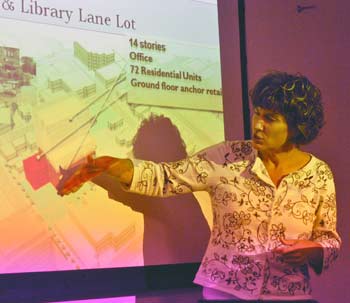
Cheryl Zuellig of SmithGroupJJR shows a slide of a possible type of development on the Library Lane lot. It’s one of many scenarios that are being discussed as part of the Connecting William Street project, which aims to form a framework to guide future development of city-owned parcels along William Street between Ashley and Fifth. Zuellig is facilitating the project for the Ann Arbor Downtown Development Authority. (Photos by the writer.)
Led by the Ann Arbor Downtown Development Authority at the behest of city council, the project’s goal is to build a framework to guide possible development of those sites, which are primarily surface parking lots: (1) the Kline’s lot (on the east side of Ashley, north of William), (2) the lot next to Palio restaurant (northeast corner of Main & William), (3) the ground floor of the Fourth & William parking structure, (4) the old YMCA lot (on William between Fourth and Fifth), and (5) the top of the Library Lane underground parking garage on South Fifth, which recently opened north of the downtown library.
Amber Miller of the DDA and Cheryl Zuellig of SmithGroupJJR led the Aug. 14 discussion and solicited feedback on three development scenarios. Broadly speaking, the scenarios represent low density, moderate density and high density development, and all conform to current zoning. They were created based on input from interviews, focus groups, an online survey, and the work of land use economist Todd Poole. [.pdf of Poole's market study]
Miller stressed that these scenarios are not recommendations for development, but are being used as conversation starters to get additional feedback. The final recommendation to the city council, which is expected in late October, will likely be a hybrid of the ideas in these scenarios.
The planning commission had a wide-ranging discussion, floating questions and suggestions. Ideas included: (1) creating spaces for food carts to give downtown workers more low-cost lunch options; (2) building structures that are adaptable, and that could easily be transformed from office to residential space; and (3) incorporating aspects of the city’s recently approved sustainability framework, as well as elements of a climate action plan that’s being developed.
Wendy Rampson, the city’s planning manager, raised concerns over Ann Arbor becoming a “Disneyland of foodies,” and stressed the importance of diversity for a healthy downtown. Poole’s market study indicates that Ann Arbor residents spend 1.6 times the national average on dining out and entertainment.
Eric Mahler, a planning commissioner who served on a committee that had recommended a development on top of the Library Lot, cautioned that the public’s response to any proposal can’t be underestimated. People will likely challenge any assumptions related to market demand, he said, such as demand for a conference center. He also indicated that parking and traffic concerns shouldn’t be underestimated – people will raise those issues, too.
Miller noted that one of the lessons they’ve learned from previous unsuccessful efforts is the importance of having conversations in advance of specific proposals, and of reaching out to a more diverse group of people. That’s what they’ve been doing with Connecting William Street, she said, and it’s what they’ll continue to do in the coming weeks as they gather input for a final recommendation.
Background: History of DDA-City Development Efforts
The idea of asking the DDA to develop guidelines for the city regarding development of this set of city-owned parcels has been discussed for more than two years. It was an outgrowth of negotiations between the city and the DDA related to an agreement that governs the DDA’s management of the city’s parking system. An initial outline of the project was given by DDA executive director Susan Pollay in September of 2010, at a meeting of city and DDA representatives on “mutually beneficial” committees formed to craft a new parking agreement. The idea was to develop guidelines based on work that’s been done over the last half-decade – including the Calthorpe process, the A2D2 rezoning process, and the downtown plan.
The first formal proposal was floated by councilmember Christopher Taylor (Ward 3) at the council’s Dec. 20, 2010 meeting, when he attached a copy of a draft resolution to the council’s meeting agenda.
A few months passed. After postponing action at earlier meetings, on April 4, 2011, the council voted to direct the DDA to explore alternative uses of these five parcels, most of which are used for surface parking. The area is bounded by Ashley, Division, Liberty and William streets. The sites included in the area are: (1) the Kline’s lot (on the east side of Ashley, north of William), (2) the lot next to Palio restaurant (northeast corner of Main & William), (3) the ground floor of the Fourth & William parking structure, (4) the old YMCA lot (on William between Fourth and Fifth), and (5) the top of the South Fifth Avenue underground parking garage, which recently opened north of the downtown library.
It’s worth noting that a pitch from former dean of the University of Michigan school of architecture Doug Kelbaugh to help facilitate a public outreach process was declined by the DDA back in the summer of 2011.
The project is now being overseen by the DDA’s partnerships & economic development committee, which in turn formed a local & outreach committee (LOC) to advise the process.
Planning commissioner Kirk Westphal is a member of the LOC. Other members are: Britany Affolter-Caine of Ann Arbor SPARK; Ron Dankert of Swisher Commercial; retired Ann Arbor Public Schools administrator Bob Galardi; attorney and DDA board member Joan Lowenstein; architect and DDA board member John Mouat; Michigan Theater board member Hillary Murt; getDowntown director Nancy Shore; Ann Arbor city councilmember and DDA board member Sandi Smith; and Bonnie Valentine of The Whole Brain Group. [.pdf of LOC member bios]
The LOC began meeting in the fall of 2011. One of the first efforts to garner feedback was an online survey, which was completed in early 2012 and yielded over 2,000 responses. [.pdf of survey results] A speaker series this spring, co-sponsored by the online publication Concentrate, highlighted topics related to downtown development.
At its March 7, 2012 meeting, the DDA board allocated $100,000 to support the Connecting William Street project. Of that amount, $65,000 comes from a community challenge grant awarded as part of a larger $3 million HUD grant received by Washtenaw County. The remaining $35,000 was made up by DDA cash (no more than $20,000) and DDA in-kind contributions of staff time.
That budget covered the costs of a consultant – SmithGroupJJR – to facilitate the process, as well as the services of a land use economist, Todd Poole of 4ward Planning.
In June, Poole delivered a market study for the project, which included projections of socio-economic trends in the downtown area through 2015. [.pdf of Poole's market study] That information and analysis was used to develop a set of scenarios for possible development of the city parcels.
This is not the first time that the DDA has looked at plans for developing multiple city-owned parcels. In 2005, an effort called the 3-site plan looked at the possibility of developing three city surface parking lots, including lots at First & William, First & Washington and the Kline’s lot on Ashley. The concept underpinning the plan was that parking could be decoupled from development – building a parking structure at First & William, for example, could free up the other two sites for development without the constraint of building on-site parking.
The DDA’s 3-site plan was never voted on by the city council, however. The site at First & William provoked controversy that continued through most of 2005 when supporters of an Allen Creek greenway objected to the use of that parcel for a parking deck. City councilmembers declined to put the plan on their meeting agenda for a vote in early 2005, although DDA board members at the time apparently believed, based on information they received from councilmembers, that there were sufficient votes on the council then to approve it. Some councilmembers apparently wanted additional time to lobby to ensure that the vote was more decisive than 6-5 on the 11-member body. But the plan was never brought forward for a vote.
The council later voted, at its July 6, 2009 meeting to designate the First & William parcel as a future part of the Allen Creek greenway.
Connecting William Street Presentation
At the planning commission’s Aug. 14 working session, Kirk Westphal, who chairs the commission, introduced the presentation by noting that he’s a member of the DDA’s leadership & outreach committee that’s advising this process. He described the committee as not the “usual suspects,” and said they’ve been working on getting input and developing the scenarios that commissioners would be evaluating at this session.
Westphal said there’s been a huge outreach effort already, and he hoped commissioners would provide insights and feedback on what’s been developed so far.
Amber Miller, the DDA’s planning and research specialist, reviewed the project’s goal: “to create strategies for transforming five city-owned sites into uses that will better serve the community.” She noted that some previous efforts to develop city property hadn’t worked well – conversations about possible development happened too late, and sites were being looked at one at a time. That approach resulted in a lot of people trying to fit different visions into a single project, and it wasn’t a successful process, she said.
For the current approach, the DDA is having the conversations upfront, she said, and is looking strategically at five sites. The goal is to develop a plan that will give direction for future development.
One reason the timing is right for this effort is the recent opening of the new underground parking structure on South Fifth, Miller said. That structure, called the Library Lane Lot, added 700 spaces to the city’s parking system. The extra capacity enables the city to think about other uses for some of the downtown parking lots along William Street.
Two other major anchors in that area are undergoing change, Miller noted. The Ann Arbor Transportation Authority’s Blake Transit Center, the downtown bus hub, is being rebuilt. [The planning commission had reviewed a site plan for that project at its July 17, 2012 meeting.] The center is located between Fifth and Fourth avenues, north of the city parking lot at Fifth and William.
Also potentially being rebuilt is the downtown library, at the northeast corner of Fifth and William, south of the underground parking structure. [In late July, the Ann Arbor District Library board voted to put a $65 million bond proposal on the Nov. 6 ballot for the building project.]
Both the transit center and downtown library draw a significant number of people to that area, Miller said, and those numbers will likely increase in the future, changing the dynamics in that part of town.
Miller said the DDA wasn’t starting over or doing its work in a vacuum.
The intent is to build off previous planning efforts, like the Calthorpe process, the A2D2 rezoning process, and the downtown plan. As part of that, they’ve taken a look at hundreds of goals outlined in various city plans, and consolidated those into a set of overarching goals to guide this process:
- Diversity of uses & center of activity
- Center of commerce & jobs
- Diversity of residential opportunities
- Dense land use & development
- Development that respects context & character-area intent
- Adequate infrastructure to support development
- Emphasis on street-level pedestrian scale & non-motorized connectivity
- Emphasis on green building & high quality material
In describing the current William Street area, Miller noted that much of the streetscape consists of empty, unattractive sidewalks and parking lots. Liberty Plaza, a city park at the corner of Liberty and Division, also isn’t used as well as it could be, she said. What people say they want is a bustling downtown, with lots of activity.
One of the first things that the DDA plans to do is to improve the streetscape, she said, similar to the recent project along Fifth and Division, which included new streetlights, trees and other changes. They’ll also focus on key street corners within the William Street area, to create more active street-level uses.
For Liberty Plaza, the DDA has had conversations with the city’s park advisory commission and others in the community, Miller said, and is recommending an investment in renewal of that park. That includes design modifications to improve accessibility and security, making the park more visible from the street and providing some kind of connection to adjacent sites, especially the Library Lane parking structure. [The park advisory commission is set to discuss a proposal for Liberty Plaza at its Aug. 21 meeting. (.pdf of proposal) The group will also be briefed on the overall Connecting William Street project.]
Miller noted that the Library Lane site includes a plaza that’s in a “no build” zone, on the corner closest to the library. That 5,130-square-foot plaza, now used for surface parking, is just a little larger than the Sculpture Plaza in Kerrytown, at Fourth and Catherine. Library Lane, a small street running between Fifth and Division, is also designed to be closed for special events, she said, which would expand the plaza area even more.
Miller then described how public input was used to develop scenarios for the five city-owned sites. The survey, with about 2,000 responses, identified an overarching theme: The desire for a vibrant downtown and active sidewalk experience. Within that broad vision, survey responses highlighted attention to other key areas: (1) building quality and design; (2) economic development – job creation and support for independent and retail businesses; (3) housing – a range of housing options, including affordable housing; and (4) open space/plazas – a range of types and amount.
The DDA also hired a land use economist to understand the market better, Miller said, including the costs and benefits of future development. Todd Poole of 4ward Planning did that work. [.pdf of Poole's market study]
Among Poole’s findings and projections:
- 1,300 new apartments could be absorbed in the downtown area by 2016, in addition to the housing that’s already under construction.
- 500,000 square feet of office space could be supported downtown – the current downtown inventory of office space is limited for floor plans above 15,000 square feet.
- Residents within a 10-minute drive of Ann Arbor spend 1.6 times the national average on dining out and entertainment.
- Retail in general should be small in scale, with the exception of recruiting an anchor retail outlet such as Apple Computer.
- Interviews and initial data analysis indicate that lodging – a hotel/conference center – is supportable.
Miller noted that the scenarios for the five sites were developed by looking for an overlap between the survey results and Poole’s report. She stressed that the scenarios aren’t recommendations – they are intended as a starting point for soliciting additional feedback from the community. Community feedback is key, but so is project viability and the public’s cost/benefit. ”We’re looking for that sweet spot right in the middle,” she said.
Miller made one final point before reviewing the scenarios: All of them were developed to conform with the city’s current zoning. In broad strokes, the three scenarios represent low density, moderate density and high density development. [.pdf summarizing the three scenarios]
Scenario A: Low Density
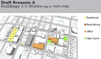
In this first scenario, the buildings on the sites would generally range from 3-5 stories, with a floor-area ratio (FAR) of up to 400% – the maximum FAR allowed in D2 (downtown interface) zoning districts. FAR, a measure of density, is the ratio of the square footage of a building divided by the size of the lot. A one-story structure built lot-line-to-lot-line with no setbacks corresponds to a FAR of 100%. A similar structure built two-stories tall would result in a FAR of 200%.
The Ashley and William site – the Kline’s lot – could accommodate 68 townhomes in several three-story buildings. The lot at Main and William could remain a surface parking lot, and be used for special events as needed. Facade improvements would be the only change on the first floor of the Fourth and William parking structure, while the Fifth and William lot could have a four-story building with ground floor retail/restaurant space and offices above. This scenario includes a four-story building on the Library Lane site, also with ground floor retail/restaurant space and office or residential on the upper floors.
Scenario B: Moderate Density
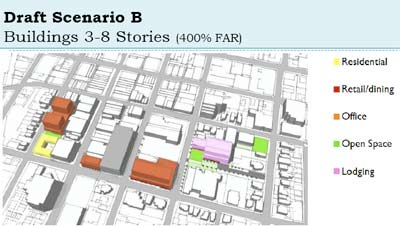
For Scenario B, buildings could range from 3-8 stories, also with a FAR of up to 400%. At the Kline’s lot, two mixed-use structures – three and eight stories – could include 18 townhouses, some ground floor office space as well as offices on upper floors. The lot at Main and William, next to Palio, could have a five-story building with ground floor retail/restaurant space, and offices above. At the Fourth and William parking structure, the ground floor would include a small business incubator space – a modest conversion of the roughly 2,500-square-foot office that’s now used by Republic Parking – in addition to facade improvements.
The Fifth and William lot could have an eight-story building with ground floor retail/restaurant space and offices above – taller than the proposed building in scenario A. And the Library Lane site could have a seven-story building with ground floor retail/restaurant space, a plaza and a 180-room hotel.
This scenario would satisfy 83% of the anticipated demand for office space, but only 1% of demand for residential housing, based on Poole’s market analysis.
Scenario C: High Density
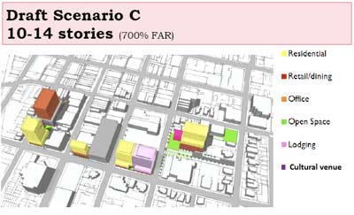
In Scenario C, buildings generally range from 10-14 stories, with a FAR of up to 700%. That higher percentage FAR is available within the zoning code, if certain criteria are met. Those criteria include affordable housing units, pedestrian amenities, and energy efficiency, among other things.
Two buildings at Ashley and William – 15 stories tall – could include ground floor retail/restaurant, 95 residential units, offices, and a “cultural venue,” such as a museum or performance space. There might be a public greenspace between the buildings, to form a kind of connector between Main Street and the Allen Creek greenway.
Retail/restaurant space, 24 residential units, and office space could be accommodated in a 10-story building at Main and William – taller than the adjacent Fourth and William parking structure. The ground floor of the parking structure could house a large business incubator of perhaps 10,000 square feet.
This scenario includes 13-story building at Fifth and William – the former YMCA lot – with ground floor retail/restaurant, 84 upper-level residential units and a 330-room hotel. This site might also accommodate some underground parking.
The Library Lane site could have a large retail anchor – like Crate and Barrel – in a 14-story building with 72 residential units and offices on upper levels.
Commission Discussion
The planning commission had a wide-ranging discussion about these different scenarios. They were asked individually to complete a feedback form, giving input on the specific scenarios as well as general development priorities. The following report summarizes highlights from their discussion, organized thematically. The discussion was led by Cheryl Zuellig of SmithGroupJJR and Amber Miller of the DDA.
Commission Discussion – Adjacent Property
Kirk Westphal wondered what the zoning was on the west side of Ashley, across from the Kline’s lot. Wendy Rampson, the city’s planning manager, reported that the west side of Ashley between William and Liberty is zoned D2 – a less dense zoning designation that acts as an interface between the highest density D1 zoning and the residential neighborhoods. It is not located in an historic district, she noted.
Westphal said one concern that’s been raised is the possibility of developers assembling lots so that they can build taller structures. It’s worth thinking about what might be possible to build on nearby property, so that the development on city-owned parcels isn’t out of scale.
Rampson pointed out that the lots on the west side of Ashley are relatively shallow, only about 90 feet deep. That depth would limit a building’s height, she said. She also noted that much of the city-owned parking lot further west at First & William is in the floodplain, which also limits what can be built there.
Wendy Woods said that shadow studies would be important, to indicate the impact of development on adjacent parcels.
Cheryl Zuellig wanted to know if the Connecting William Street presentation at future forums should include a discussion of building height on adjacent lots. That depends on whether you want to rile people up, Ken Clein joked. Bonnie Bona noted that building height was an important aspect of the recent A2D2 rezoning process.
Commission Discussion – Fourth & William Parking Structure
Cheryl Zuellig noted that the Fourth & William parking structure was “a bit of an outlier” in this project because it’s the only site that is not a surface parking lot. People have strong opinions about it, she said, and the streetscape around it is not an active one.
Susan Pollay, the DDA’s executive director, raised the possibility of bringing other transit activities there, such as offices for the Greyhound bus station. She noted that there’s already a stop there for AirRide, the service to Detroit Metro Airport.
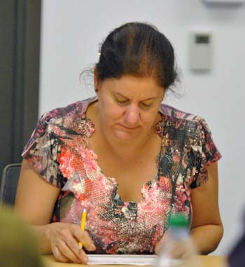
Diane Giannola fills out a feedback form for the Connecting William Street project at the Aug. 14 working session of the Ann Arbor planning commission.
Wendy Woods wondered whether there’s any talk about removing the structure. That’s unlikely anytime soon, Pollay replied, because another level was added and other renovations were done relatively recently. Another 10 years remain on the bonds to pay for that work. ”Unlovely as it is,” she said, “it does have a lot of value in it.”
Pollay also noted that a key emphasis is now on maintenance for the city’s parking structures. The reason that the Forest Street and Fourth & Washington structures had to be rebuilt after only 30 years or so was because those structures hadn’t been maintained well and had deteriorated, she said. But if well-maintained, a parking structure “will outlast all of us,” she said.
Zuellig also noted that if the Fourth & William structure is taken down, those parking spots will need to be replaced elsewhere. It’s a good location to serve the Main Street area, she said, so removing it doesn’t seem like the wisest choice. She also joked that it was built so long ago that in 10 years, it will likely be considered an architectural gem.
Woods said she understood all of that. But she wondered, if they were starting from a clean slate, would that site be better used as a performance venue or for residential housing.
Diane Giannola wondered if facade improvements would eliminate the Fourth Avenue entrance/exit. No, Pollay said. Any changes would have to work within the current layout, and the Fourth Avenue entrance/exit is an important one. [The other entrance/exit is on William Street.]
Giannola also advocated for a place to have food carts in that area. She noted that there are limited inexpensive lunch options for downtown workers, and food carts could bring variety and moderate prices, along with enlivening the area.
Commission Discussion – Affordable Housing
Evan Pratt asked whether affordable housing would be a component of the recommended development of these sites.
Susan Pollay said the DDA has been trying to understand the needs and best practices for affordable housing, and has been talking with the Washtenaw Housing Alliance, the city/county office of community & economic development, and others working in that sector. Whatever recommendation is made from the Connecting William Street effort should be aligned with other community strategies toward affordable housing, she said.
Twenty years ago, Pollay continued, best practices called for including affordable units within each project. That might not be the best strategy today. She gave an example of an affordable housing unit at Ashley Mews that someone has been trying to sell. But because the common-area costs are rising at that complex, people who fall into the income requirements for the condo can’t afford the other costs associated with living there. Another example is the Corner House Lofts at State and Washington, she said, which are targeted primarily toward the student housing market. It might not be the best place for someone older to live, even though they’re eligible for the affordable housing units.
Commission Discussion – Office vs. Residential
During the scenario presentation, it was noted that Todd Poole’s report recommended prioritizing the development of office space rather than residential. Bonnie Bona asked for more information about that recommendation.
Amber Miller replied that during interviews and in the survey, economic development and job creation had been a clear priority. The residential market is hot, she noted – developers are already bringing those kinds of projects forward. But there’s a clear need for office space, especially for larger office footprints. Cheryl Zuellig had earlier noted that her company, SmithGroupJJR, is a poster child for that situation. The company couldn’t find adequate office space to accommodate its growth, so it had to move out of the downtown area and into a building on Depot Street.
Because the city owns these five sites and has more control over the uses there, Miller said, it might make sense to prioritize office development over residential at this point.
Bona stressed the importance of building structures that are adaptable – buildings that can be used for offices now but that can be easily converted to residential or other uses in the future, as the market changes. She noted that a friend of hers owned an office condo in Tally Hall [now called Liberty Square], and converted it from office to residential. It wasn’t an easy task, she said, because of building code requirements.
Wendy Rampson, the city’s planning manager, observed that the same thing has happened at Sloan Plaza on East Huron. Two floors of office space have gradually been converted to residences, but it hasn’t been an easy process, she said.
Commission Discussion – Library Lane Site
Kirk Westphal asked about the footings in the Library Lane underground parking structure, and how much development those were designed to support.
Susan Pollay replied that the project cost roughly $50 million, and about 30% of those costs related to infrastructure for possible future development. The footings in one corner of the site are designed to support a building at least 20 stories high. It’s in excess of current height limits that were subsequently finalized after the project began. The intent was to give the city maximum flexibility, she said. Columns, elevators and stairwells were designed with the same intention, as were areas that could be cut out in the future to allow for underground connections between the garage and buildings like the adjacent library. Other infrastructure features include a new alley and larger water mains.
Westphal wondered whether it would be “leaving money underground” to not take full advantage of that infrastructure. Bonnie Bona noted that there’s no reason why they couldn’t start with something like the lower density Scenario A, then 10 years later build something like what’s described in Scenario B, then eventually build the higher density Scenario C. Ken Clein observed that a complicating factor is the way that mechanicals – heating and air conditioning units, for example – are typically placed on top of buildings, making it more difficult to build up.
Wendy Woods wondered why the tallest building on the Library Lane site, in Scenario C, was only 14 stories. Zuellig clarified with planning manager Wendy Rampson that rezoning the site to a planned unit development (PUD) would allow for an even taller structure, but would require demonstration of some kind of public benefit as well.
Evan Pratt observed that the millage campaign for a new downtown library – located immediately south of the city’s Library Lane lot – is stating that more meeting space is needed downtown. Zuellig indicated that meeting space has been part of the Connecting William Street discussion.
Diane Giannola asked whether Pratt meant free meeting space or space that’s available to rent. She said she often observes that the meeting room at the library’s Mallets Creek branch is empty, and noted that the library charges people to use the space.
Pollay noted that this topic is similar to the issue of affordable housing. The next layer of discussion needs to be who pays for these things, if they aren’t market-driven. Performance space is another example – a lot of groups can’t afford to rent a theater for rehearsal. Is that something that the city should subsidize? Operation costs are the longer-term expense, Pollay noted.
Amber Miller pointed out that this issue relates to the sweet spot she had mentioned earlier in her presentation – the overlap of community feedback, project viability and the public’s cost/benefit.
Rampson noted that the scenarios also refer to independent local businesses as part of the ground floor retail component, but those types of businesses typically need cheaper rents, compared to national chains. And the new buildings that might be developed on these sites wouldn’t be cheap. Pollay replied that in some cases, residential units on upper levels might subsidize the retail space, but Rampson’s observation made a good point, she said.
Commission Discussion – Restaurants & Retail
Susan Pollay asked Diane Giannola for more details about Giannola’s food cart idea – where might they be located? Giannola said there could be places tucked away next to the Fourth & William structure, or at the Library Lane site. They wouldn’t need to be high profile, she said, but could be in places that downtown workers would know about.
Evan Pratt noted that food carts might activate other retail in the area.
Wendy Rampson said she had the opposite concern. The “restaurant-ification” of Ann Arbor is a little alarming, she said, in the context of trying to create a diverse downtown base. Restaurants are going into the ground floor space at the new Landmark apartment building on South Forest and at Zaragon West at William and Thompson. When do you reach saturation? she wondered. When is there nothing left to do downtown except eat? Todd Poole, the land use economist, seems to think that more restaurants are better, she said. But what’s the tipping point, when Ann Arbor becomes simply the “Disneyland of foodies”?
Pollay pointed to Poole’s report, stating that Ann Arbor residents spend 1.6 times the national average on dining out and entertainment. That’s what we do for recreation, she said – that’s how we spend our disposable income.
Amber Miller added that the community’s income level is pushing that desire for more restaurants. Rampson replied that she understood all that, but it’s a concern from the perspective of building a healthy downtown. Investment that’s needed to convert a retail space into a restaurant means that it isn’t easily reversed.
Pollay said that perhaps as restaurants move into newer buildings, that would free up space for retail to return to older structures, where rents might be cheaper. She noted that there had been a mini-resurgence of retail in the South State Street area.
Bonnie Bona observed that shopping malls grouped similar-type retail stores together, and there would be advantages to having clusters of similar retail shops in downtown areas, too. Kerrytown, for example, has a cluster of food stores – including the People’s Food Co-op, the farmers market, and several stores in the Kerrytown Market & Shops.
Zuellig pointed to Poole’s analysis of retail options in and around Ann Arbor. The challenge is that a lot of retail is located within a relatively close distance to downtown – at Arborland, Briarwood Mall, Maple Village and other retail centers. So the downtown retail should focus on specialty items that can’t be found elsewhere.
Wendy Woods wondered whether Poole’s report talked about bookstores. She recalled that in the past, after having dinner downtown, she could go browse at local bookstores. But there aren’t many left now, even though Ann Arbor is supposed to be an intellectual capital. Zuellig indicated that Poole didn’t discuss the demise of bookstores. Pratt joked that perhaps Woods should have bought more books rather than browsed.
Commission Discussion – Public Reaction
Eric Mahler cautioned that the public’s response to any proposal can’t be underestimated. There was a lot of outcry about public/private proposals for the Library Lane site, he recalled, and calls for more market analysis. [Mahler was part of the committee that evaluated proposals for that site. The committee recommended a proposal by Valiant Partners, but it was ultimately rejected by the city council in April of 2011.]
Mahler said he imagined that residents of the Old West Side would be particularly involved. There will likely be a lot of call for green space, he said, and people will want to know a high level of detail regarding any recommendation. There’s generally a big concern about building white elephants, he noted – people will likely want a level of detail that can’t be provided.
Cheryl Zuellig noted that until a developer puts a specific proposal on the table, it’s not possible to provide the kind of details that people might want. The intent of this project is to set a framework that the city council and the public can use to evaluate proposals that are made by developers.
Mahler said that people will likely challenge any assumptions related to market demand, such as demand for a conference center. He also cautioned that parking and traffic concerns shouldn’t be underestimated – people will raise those issues, too.
Amber Miller noted that one of the lessons they’ve learned from previous development efforts is the importance of having conversations in advance of specific proposals, and of reaching out to a more diverse group of people.
Susan Pollay, the DDA’s executive director, agreed with Mahler’s observations. One of her takeaways is that more information is better. One example is identifying the value of a property. That’s where the assessment of someone like Todd Poole could be helpful, she said. The DDA should also get ahead of the conversation by identifying what it’s willing to do with regard to parking and tax increment finance (TIF) capture. The goal is to find the areas where there’s the most agreement – a middle ground, she said. “We’ll know it when we find it.”
Kirk Westphal said that this meeting was the first time since the Library Lane RFP process that he’s heard the term “public/private partnership” raised. At the leadership & outreach committee, the idea of public/private partnerships hasn’t come to the table, he said. Rather, the possibilities have ranged from selling property to setting very detailed specifications for developers.
Zuellig replied that just by its very nature, a private development on public land would be a public/private partnership. That doesn’t mean there will be subsidies or incentives, she added, but there needs to be a good working relationship. That’s been an issue brought up in many interviews, Zuellig said – working with the city hasn’t been the greatest experience in the past.
Evan Pratt noted that developers desire a predictable process, and that’s not what typically has happened. Westphal observed that on the flip side, the city doesn’t want to be on the hook for a bond or other investment related to private development.
Pratt also said that strong opinions are less likely to be voiced in small focus groups, but those strong views will likely emerge at larger public meetings. He said it would be good to have recent occupancy rates for local hotels and offices, to include in the presentation. He wondered if Poole’s report commented on the demand for a hotel. Amber Miller replied that Poole had received feedback during interviews with realtors and developers that there’s a demand, and that in other university towns of a comparable size, there are more downtown hotels than in Ann Arbor.
Commission Discussion – Sustainability, Climate Change Plans
Commissioners also suggested that the Connecting William Street recommendations should incorporate aspects of the city’s recently approved sustainability framework, as well as elements of a climate action plan that’s being developed.
By way of example, planning manager Wendy Rampson suggested that one question to ask the community is whether there are any energy-related components that the city should be willing to subsidize. Bonnie Bona, who serves on the task force that’s developing the climate action plan, noted that even if the city implements all of the plan’s suggestions, they’ll barely meet the 2025 goals for energy reduction and will fall far short of meeting the goals set for 2050.
Susan Pollay said that the top of the Fourth & William parking structure would be a perfect place for solar panels. It might be time for the DDA to look at what it can do incorporate that kind of element, complementing the other uses on the five sites.
Next Steps
Amber Miller outlined the next steps in the process. In late August and early September, they’ll hold additional meetings with specific groups as well as a couple of public forums. They’re also planning some webinars, for people to participate online.
In September, they’ll use the feedback they’ve received to develop a hybrid from the scenarios and craft a recommended draft plan. In late September and early October, that recommendation will be reviewed with the public through meetings and surveys for additional input and revisions.
Miller said they hope to have a final recommendation – including recommendations for implementing, and for decision-making tools – to present to the city council in late October.
The Chronicle could not survive without regular voluntary subscriptions to support our coverage of public affairs. Click this link for details: Subscribe to The Chronicle. And if you’re already supporting us, please encourage your friends, neighbors and colleagues to help support The Chronicle, too!



“The final recommendation to the city council, which is expected in late October, will likely be a hybrid of the ideas in these scenarios.”
Mary, are those your words or Miller’s?
Re. “are those your words or Miller’s”: I’m paraphrasing – that is, it’s not a direct quote – but she did use the word hybrid, if that’s what you’re asking. Their goal isn’t to ask people to select scenario A (B or C) in its entirety, but to identify elements of each scenario that people prefer.
Thanks, Mary. If she used the word “likely”, that would be sufficient to demonstrate a predisposition to certain options (conscious or not) on the part of the DDA.