AHP Zoning Revisions Go to City Council
Ann Arbor Planning Commission meeting (July 8, 2010): The 4th of July holiday caused some reshuffling of city meeting times and locations, and sent planning commissioners to the Ann Arbor District Library on Thursday night to conduct their business.

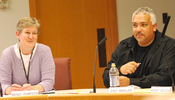
Wendy Rampson, head of the city's planning staff, and Eric Mahler, newly elected chair of the Ann Arbor planning commission, at the commission's July 8, 2010 meeting. (Photos by the writer.)
That business included approval of revised area, height and placement (AHP) standards that have been under review for more than two years. The revisions have pulled back from some of the original proposals – for example, there’s no longer an uncapped building height in certain districts. It’s the first significant overhaul of these standards in roughly 50 years, with the goal of reflecting prevailing community values. The recommendations will now be forwarded to city council for final approval.
The planning commission also voted to postpone action on a project at the Kroger on South Maple. The grocery is adding a drive-thru pharmacy, and needs city approval to reconfigure its parking lot to accommodate the drive-thru lane. A few unresolved issues led commissioners to push back consideration until their July 20 meeting.
And the commission elected a new slate of officers, with local attorney Eric Mahler replacing architect Bonnie Bona as chair.
Area, Height & Placement
The fact that no one spoke during the meeting’s public hearing on changes to the city’s area, height and placement standards might be attributable to the July 4th holiday week, or it could be related to the multiple public forums held on the topic over the past year, most recently on June 16, 2010. [For a primer on AHP, see Chronicle coverage: "Zoning 101: Area, Height, Placement." Additional information is on a page of the city's website dedicated to the AHP revision process.]
Revisions to these standards have been in the works since 2007, when the planning commission and staff started looking at doing a comprehensive update – for the first time in more than 50 years. The rationale for making revisions is summarized in a planning staff report that accompanied the proposed changes:
More recently, best practices in urban planning and environmental design recommend a more sustainable approach to land use practices including: a) more compact use of land and infrastructure, b) the preservation of natural systems, c) accommodating new growth along transit corridors in existing urban areas which have existing infrastructure, d) locating buildings closer to the right-of-way to promote non-motorized access, and e) mixed land uses. The challenge that decision makers in Ann Arbor now face is that current ordinances related to area, height and placement do not encourage these land use practices.
After working with an advisory committee, in the summer of 2008 the planning commission passed a recommendation for initial revisions.
Planning staff presented the recommendations to a city council work session in September 2008, and got direction from council to get additional public input about the changes. Eight public workshops were held, and at its Dec. 7, 2009 meeting, the council passed a resolution kicking the issue back to the planning commission for further consideration. Since then, planning staff and the commission’s ordinance revisions committee have been working on further revisions. Those revisions were presented to the full commission at their July 8 meeting.
AHP: Proposed Changes to Draft
Based on public input, as well as staff and committee review, there are a raft of proposed changes to the AHP amendments that were originally drafted. [.pdf of summarized list of substantive AHP changes and .pdf of complete revisions] Here’s a general overview of some of the current proposed changes:
- Area: “Area” is a measure of density, specifically using a floor-area ratio (FAR). FAR is the ratio of the square footage of a building divided by the size of the lot. A one-story structure built lot-line-to-lot-line with no setbacks corresponds to an FAR of 100%. A similar structure built two-stories tall would result in an FAR of 200%. Originally, three retail zoning districts had a proposed FAR of 200%, an increase compared to the current maximum of 40-50%. Some of those increases were scaled back under the revised draft. Now, the proposed FARs are: 1) 100% in the C1 retail district; 2) 150% in the C1B retail district; and 3) 200% in the C3 retail district.
- Height: Building heights in four zoning districts – office, retail, research, and research & light industrial – had originally been proposed as uncapped, but now have height limits of 55 feet and four stories. The maximum height for hotel districts – originally proposed for 120 feet – now have height limits of 50 feet, or up to 80 if there is parking below at least 35% of the building. The maximum height in the C2B (business service) zoning district has been reduced from 60 feet to 55 feet.
- Placement/Setbacks: “Placement” regulations govern where a building can be constructed within a particular lot, and are expressed in terms of “setbacks.” For example, a 25-foot minimum front setback would mean that a building needs to have a 25-foot buffer between it and the front lot line. There are several setback changes proposed. In the original proposal, setbacks in two retail zoning districts – C1 and C1B – had no minimum setback, compared to the existing 25-foot minimum. Now, the minimum setback is proposed at 10 feet.
Jeff Kahan of the city’s planning staff is the point person for the AHP initiative, and gave the staff report to commissioners.
No one spoke during a public hearing on the AHP changes. Earlier in the meeting, Rampson had said that the official notice of the meeting had included an incorrect start time – 7 p.m. – which might result in people coming late. Though planning commission meetings typically start at 7 p.m., Thursday’s meeting began at 6 p.m. to accommodate the change of venue. However, no one arrived to address the commission – there were no speakers during the final opportunity for general public commentary, either.
AHP: Commissioner Discussion
During their discussion of the AHP changes, commissioners primarily asked clarificational questions and gave some feedback, but did not suggest substantive revisions.
Evan Pratt asked a question about instances when a “skinny” piece of land doesn’t abut a residential property, but comes close. He asked whether they could modify the language to indicate a distance, rather than specify only parcels that abut residential.
Pratt was referring to the following changes, as outlined in a memo from the planning staff:
• Increase side and rear setbacks where non-residential abuts residentially zoned land from 20’ to 30’ wherever 20’ was required
• Require additional 1 foot side and rear setback for each 1 foot of building height above 30’ (e.g. a new 55’ building abutting residential would need to be set back 55’ from the residential property line)
• Restore the 100’ setback requirement for RE (Research) for side and rear setbacks
• Proposed adding modifications to Chapter 62 (Landscaping & Screening) in the following manner: a) add multiple family uses to those uses requiring a conflicting land use buffer when abutting residential property; b) increase the number of required trees in the conflicting land use buffer from 1 tree per 20 lineal feet to 1 tree per 15 lineal feet. This change is being coordinated with Public Services (Systems Planning) which is currently pursuing amendments to Chapter 62.
Kahan said he could talk to Kerry Gray and Jerry Hancock, members of the city staff who are handling revisions to Chapter 62. The overall goal is to provide a buffer to residential areas, he said.
Pratt next asked whether the lower building height for hotels (R5 zoning districts) was in response to public input. He noted that those parcels don’t seem to be imposing on any residential areas. Kahan confirmed that the R5 districts are proximate to freeways: the South State corridor at I-94, Plymouth Road at US-23, and Jackson Road at I-94. The main concern from the public had been uncapping height limits, he said. Responding to a follow-up from Pratt, he clarified that there are no FAR restrictions in those districts – there are no limits to a building’s massing.
Pratt said that Ann Arbor isn’t currently a big hotel town, but looking to the future, that might change.
Bonnie Bona spoke next, noting that other than Kahan, she was the only other person on the commission who’d been around throughout the long AHP process. The longer they’ve worked on it, she said, the more it feels like they’re going backwards – but that’s not the case. The current changes are a step back from a year ago, but are far better than the existing standards.
She made several observations about the revisions – noting, for example, that restrictions to height limitations in R4 (residential) districts do not include the R4C district. That’s because a separate study committee is looking at revisions to R4C and R2A districts.
Overall, “we’ve come a long way with this,” Bona said, adding that she thinks it will reduce number of planned projects that are proposed. [Planned projects are those requiring zoning variances, but not a rezoning as with planned unit developments.]
Diane Giannola raised a question about an additional one-foot setback requirement:
Require additional 1 foot side and rear setback for each 1 foot of building height above 30’ (e.g. a new 55’ building abutting residential would need to be set back 55’ from the residential property line)
Not many parcels – other than Georgetown Mall on Packard – would fit into this category, she noted. She wondered why it was necessary to include it, given that there were so few parcels to which the requirement would apply.
Kahan cited a few other applicable properties: The Colonnade on Eisenhower, the Cranbrook shopping plaza at Ann Arbor-Saline and Eisenhower, the Busch’s plaza on Green Road. These “micro-sized” lots won’t be able to easily build up to 55 feet, he noted, unless they put parking underground, which is expensive. Smaller developers won’t likely take advantage of the extra height option, but larger developers would be able to afford it.
Jean Carlberg added that in looking toward potential future development, there needed to be those safeguards on height and setback.

Planning commissioners Evan Pratt, left, and Kirk Westphal at the July 8, 2010 planning commission meeting.
Kirk Westphal asked about changes in the C2B retail district. FAR isn’t changing, but rear setbacks are going from none to 30 feet when abutting residential, plus an extra foot for every additional foot of height. He wondered whether that would pose an additional hardship for property owners – for example, along Stadium Boulevard. In other districts, there’s been an increase in FAR to promote compact development closer to the street.
Kahan said that overall, the intent is not only to increase workability, but also to ensure consistency among the city’s employment and commercial districts. He noted that a big plus is the large reduction in the required front setback – a minimum of 40 feet is being reduced to 10. They’re hoping that it will increase pedestrian-oriented development, Kahan said, with buildings positioned closer to the street and away from neighborhoods.
Westphal said he’d forgotten about the dramatic decrease in front setbacks.
Eric Mahler said he was a little confused about the phrase “below at least 35% of the building,” in reference to parking. Kahan clarified that at least 35% of the building’s footprint would need to include underground parking, in order to gain height premiums in certain districts. The intent is to encourage putting parking underground, he said.
Wendy Woods noted that there had been a lot of public input and staff input in this process, and that it truly was a community effort. She applauded planning staff for attending the many public meetings on the topic.
Outcome: Changes to the area, height and placement standards were unanimously approved. The city council will consider and vote on the issue at an upcoming meeting before the changes can take effect.
After the vote, Mahler wrapped up by saying, “That long saga comes to an end – good work.”
Kroger Site Plan Postponed
Owners of the Kroger store on South Maple, near the Westgate Shopping Center, want to add a drive-thru pharmacy on the south side of the building, and need city approval to reconfigure the parking lot to add a drive-thru lane.
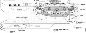
The proposal includes widening the driveway along the south side of the building, and removing 14 of the 22 existing parking spaces there. Even after eliminating those spaces, the site will have 42 spaces more than the maximum allowed by code. [The grocery store site pre-dates changes to zoning that imposed a maximum number of parking spaces.] The existing walkway and landscaped areas will be reconfigured, with a pedestrian walkway flowing through an island that’s encircled by the pharmacy drive-thru lane. Bicycle parking will be moved to the front of the store.
Staff is proposing modifications to the driveway width and configuration, narrowing a proposed east-west lane from 35 feet to 26 feet.
The planning staff presentation was made by Alexis DiLeo, and the staff recommendation was for postponement.
Kroger Site Plan: Public Hearing
Two representatives of the Kroger project spoke during the public hearing.

Jeffery Scott, an architect based in Farmington, is working on the Kroger addition and spoke to the planning commission about the project at their July 8 meeting.
Jeffery Scott introduced himself as the architect on the project. He explained that trucks going back to the store’s loading dock often jump the curb on the southwest corner, and the reconfiguration would give those semis a wider turning radius. He said he was confident that they could tweak the project to the city’s satisfaction, with the caution that they didn’t want to make the overall configuration “too curvy.” He asked that the planning commission approve the project, contingent on “fine tuning” some of the details with city staff.
Stephan Hennard of Kroger’s Michigan operations, based in Novi, introduced himself and indicated he was there to answer questions, if commissioners had any.
Kroger Site Plan: Commissioner Discussion
Bonnie Bona began by asking for additional clarification from Scott about the driveway width. Scott said the site plan proposes to widen the driveway to allow trucks more room to maneuver. Bona indicated that the city staff would work with Kroger on that.
She then asked whether Kroger considered moving the parking spaces further west, noting that there’s 32 additional feet beyond the end of the parking area. She also wondered whether they could eliminate one or two of the parking spots along that stretch. DiLeo said they hadn’t considered that, but it might be possible, given the excess amount of parking on the overall site. She said the staff wouldn’t mind if all the spaces were removed from the south side and replaced with landscaping – a suggestion that Bona endorsed.
Wendy Woods agreed with Bona that reducing some of the parking to the west of the drive-thru would be good. She was concerned that customers parking in those spots would have to walk across the drive-thru lane in order to get to the store’s entrance. She was also concerned about pushing carts along that path in inclement weather. Scott noted that the volume for drive-thru customers isn’t high – typically four cars per hour, on a good day.
Woods asked whether the pharmacy would be open 24/7. Hennard indicated that the pharmacy would close at 9 p.m. on Monday-Saturday, and at 6 p.m. on Sunday. Responding to other queries, he said that there is lighting on that side of the building, and that there would be yield signs and pavement markings to guide both traffic and pedestrians.

A site plan detail of the proposed pharmacy drive-thru at the Kroger on South Maple Road. (Links to larger image)
Erica Briggs wondered whether it would be possible to remove the parking spaces along the store’s southwest side, saying it’s potentially confusing for customers to have parking there. She also asked whether the sidewalk next to the parking was envisioned as a staff break area.
Hennard said that Kroger could mark those spots as employee-only parking. The area next to the parking has picnic tables and is the only outside break area for staff, he said.
Earlier in the discussion, Tony Derezinski had noted that they needed to decide between two options: 1) approve the site plan, contingent on working out any unresolved issues, and 2) postpone the vote. He pointed out that Scott would like to know generally whether the commission approves of the project, and it seemed that they did, he said. Derezinski then asked DiLeo whether this could be brought up at the commission’s next meeting – was there sufficient time to wrap things up by then?
DiLeo noted that the next regular meeting was on July 20, and if they canceled their Aug. 3 meeting [which they did, later in the meeting], then the next meeting after that was Aug. 17. Two weeks would be tight, she said, and there are no guarantees that they could finish, but they’d make every effort.
DiLeo said there were five outstanding issues to address, including 1) coming to agreement about modifying the driveway width; 2) updating the “existing conditions” sheet to reflect the current site, specifically showing the wireless communications tower, accessory buildings and enclosure; 3) revising a comparison chart to include all variances that had been previously granted for the site; and 4) showing documentation that Kroger will get a temporary grading easement from the adjacent property owner.
Outcome: Commissioners voted unanimously to postpone the project until their July 20, 2010 meeting.
New Officers Elected, Election Day Meeting Canceled
The commission elected a slate of new officers at their July 8 meeting, which had been moved from Tuesday to Thursday because of the July 5 holiday. Slips of paper were distributed for anonymous voting, but when it became clear that none of the seats were contested, they bagged the written ballots and held elections by a show of hands.
Eric Mahler is the new chair, taking over from Bonnie Bona. Vice chair is Kirk Westphal, and Diane Giannola was elected secretary. Bona walked over to Mahler, handed him the wooden gavel, shook his hand – and once again, a smooth democratic transition was secured.

Diane Giannola, the planning commission's newly elected secretary, proposed canceling their Aug. 3 meeting to accommodate the primary election.
Later in the meeting, another organizational issue emerged. Giannola proposed canceling the commission’s Aug. 3 meeting, since it falls on the date of the primary elections. Giannola said that in general, she didn’t think that any city business should be done on that day, in order to give people the chance to vote.
Wendy Rampson of the city’s planning staff indicated that things were pretty quiet – the Kroger site plan was the only item coming up that she was aware of. Giannola asked whether they could make it a standard practice not to schedule meetings on primary election days – it would be consistent with the practice of not holding meetings on the date of the November general election. Bona said that one good thing about having it as a standing practice is that they could set their official meeting calendar with that in mind, rather than setting the date and then canceling it.
Tony Derezinski said it would be possible to consider, given that they were currently revising their bylaws. But he noted that the next batch of commissioners might have a different view, and perhaps they’d want the flexibility to make that call themselves.
Mahler suggested running the question by the city attorney’s office. A vote to cancel the Aug. 3, 2010 meeting passed unanimously.
Present: Bonnie Bona, Erica Briggs, Jean Carlberg, Tony Derezinski, Diane Giannola, Eric Mahler, Evan Pratt, Kirk Westphal, Wendy Woods.


Regarding the Kroger drive thru, I can say from experience getting a handicapped person to the store, those spots on the south side are invaluable because of the relentless traffic in the front. When that parking is removed, I won’t go there anymore, it’s too frustrating and unsafe to cross. They could double the handicap spaces in front, it still won’t open the bottleneck forcing so many cars to cross in front of the store. The same holds true for most of Westgate, but Kroger is worse.
I have not reviewed these changes carefully in comparison to my notes from last year, but it appears to me that the staff changes faithfully respond to much of the public comment from last year.
I’m particularly glad that they eliminated the maximum setback from R2A/R2B. It seemed possible that this could affect the ability of people to grow food in their front yards. Even a small raised bed, as now being seen in many front yards, can be an important addition of fresh food to a household’s diet.
Also, limiting the R1E house size to 2,000 SF was, in my opinion, an appropriate and prudent step to make these potential small infill projects, as they say, “affordable and diverse”.
Another welcome feature was the additional commercial height limitations adjacent to residential areas. That was something many of us expressed concern about, since many of our small commercial areas abut residential neighborhoods.
Re Kroger: you have “five outstanding issues to address”, numbered 1 through 4. Was there a fifth of any significance?
Very happy to see the smaller setback requirements going into effect.
Re. #3:
The fifth issue: Kroger needs to submit an Ann Arbor Geodetic Reference System (AAGRS) Coordinate Transformation Worksheet. [.pdf file of the worksheet]