


Action on Argo Headrace, Trails Near Fuller
Ann Arbor park advisory commission meeting (Aug. 16, 2011): During a three-hour meeting on Tuesday, park commissioners walked down several topical trails in what PAC chair Julie Grand aptly described as a “super-packed” agenda.

The view looking east down the dewatered Argo headrace, with the embankment on the right. The trail along the embankment to Broadway is closed, as the city prepares for major reconstruction of the headrace. (Photos by the writer.)
Commissioners approved a resolution recommending a change to the scope of work at the Argo headrace – a change that will add a new entrance to the soon-to-be-reconstructed waterway from Argo Pond to the Huron River. The modification to the project was linked to an offer from DTE to pay for a whitewater section that’s part of the overall project, which freed up city funds for the new entrance. A state permit needed to start the reconstruction is expected to be received by Aug. 23.
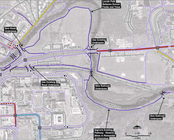
A second resolution introduced at Tuesday’s meeting urged the city council to incorporate design of a trail system – including the county’s Border to Border (B2B) trail – into the Fuller Road area in advance of building the proposed Fuller Road Station. Two members of the Washtenaw Bicycling & Walking Coalition were on hand with suggestions for where trails might be located to bypass the busy intersection of Fuller Road, Maiden Lane and East Medical Center Drive.
The topic of trails also emerged tangentially during a presentation by PAC vice chair John Lawter on dog parks. Some people walk their dogs off leash on park trails and in other park areas, violating Ann Arbor’s ordinance requiring dogs to be leashed. The exception is in the city’s two dog parks, on the north and south edges of town.
Lawter suggested that Ann Arbor might find other ways to let dogs off leash, either by creating another traditional dog park that’s more centrally located, or designating certain hours for dogs to be off leash in specific parks. PAC might form a subcommittee to explore options for a new dog park, and for how to increase enforcement of existing dog-control ordinances. Such an effort might uncover more data points like those Lawter provided in his presentation, which included the pounds of poo collected annually at Swift Run dog park.
Data collection has also been part of developing the city’s first urban forest management plan. Oliver Kiley of JJR, the consultant leading this project, updated the commission on the effort. Possible outcomes include a recommended maintenance plan, protections for mature trees, targets for new tree plantings, and proposals for relevant ordinances and zoning. The discussion among commissioners led to concerns over whether the city is prepared for something similar to the emerald ash borer – which decimated thousands of trees in the city over the past decade and chewed up the city’s forestry budget for several years.
The urban forest management plan will be among the 26 city plans in a sustainability framework being developed, focused on “triple-bottom line” goals of economic vitality, environmental quality and social equity. The commission was briefed on this project in preparation for a Sept. 27 joint meeting of the park, planning, energy and environmental commissions. The goal of that meeting is to start prioritizing goals from these existing city plans.
Argo Dam Update
Brian Steglitz gave an update on the city’s reconstruction project at the Argo dam headrace, as commissioners were asked to recommend amending the project scope with TSP Environmental. Steglitz is the city’s project manager for the Argo reconstruction. [.pdf of staff memo and resolution]
TSP, a Livonia firm, had been hired last year to build a dam bypass channel in the headrace for $988,170 and to add whitewater features for an additional $180,000. However, DTE is now offering to pay for the whitewater feature of the project, if the city agrees to hold off on construction of that piece until after DTE completes environmental remediation on its nearby property, as required by the state.
By having DTE pay for the work, the city is expected to save $163,636. The resolution at Tuesday’s PAC meeting recommended using some of these funds to improve the entrance to the headrace. That work had not previously been part of the project’s scope.
Steglitz told commissioners that the additional work would include modifying the entry into the headrace by removing the top of the concrete culvert, adding grouted limestone to widen the approach, building new concrete abutments, and installing an arched prefabricated steel clear span bridge with a concrete deck. The work is expected to cost about $85,000.
A July 25 memo from city staff reported that the city had been notified by DTE officials of upcoming remediation work that DTE plans to do in 2012, adjacent to DTE’s property on the south side of the Huron River, between Allen Creek Drain and the Broadway Bridge. The remediation is being required by the Michigan Dept. of Environmental Quality. The city is currently in negotiations with DTE about the details of the work it will do related to the headrace and whitewater features, Steglitz said.

Brian Steglitz gives a presentation on the Argo headrace project to the city's park advisory commission.
The overall Argo dam project, as previously approved, calls for removing the canoe portage and replacing it with a series of “drop pools” so that no portage is required. Originally, five pools were proposed, but that has increased to eight pools, Steglitz said. Grade changes on the drops between pools will be less steep, to accommodate fish movement through the headrace. The change will also make it easier for novice canoers and kayakers to navigate, he said. [.pdf of Argo headrace design and bridge info]
Other work includes improving the accessibility of the path – which is part of the county’s Border-to-Border trail – and addressing problems in the headrace embankment.
The work is tied to a consent agreement that the city reached with the state in May 2010, laying out steps that the city must take to deal with some of long-outstanding structural issues with the earthen embankment. TSP Environmental had been selected by the city council at its Nov. 15, 2010 meeting, following a recommendation by PAC in October 2010.
Steglitz told PAC that the city hasn’t yet received the necessary state permit to begin major work on the project. The city applied for the permit in April, and since then has been responding to comments and additional requests for information from the state. City staff expect to receive the permit by Aug. 23, after which work will begin immediately. There’s a Nov. 15 deadline from the state related to the consent agreement, Steglitz said, which had originally been set based on receiving a permit in May. Meeting that deadline now will be aggressive, he noted, but for the most part doable – and the state will likely be flexible, if necessary, given that work couldn’t begin when planned.
Steglitz also said that some work almost certainly won’t be completed by Nov. 15, such as paving the path and putting in plantings. That work will be finished up next spring.
Meanwhile, some work that didn’t require the permit has been done, including tree removal and dewatering of the headrace, which Steglitz said has been a battle. The trail along the embankment has been closed, and detour signs are up.
Argo Dam: Commissioner Discussion
Colin Smith, the city’s manager of parks and recreation, urged commissioners to visit the Argo site, saying it was exciting to see that some work has begun. He also noted that Gary Lacy, the Colorado consultant who’s designing the project, had previously talked about the benefits of improving the entryway to the headrace, if possible. City councilmembers had also expressed interest in that when they initially approved the project, he said.
David Barrett asked whether TSP Environmental will still build the whitewater feature, now that DTE is paying for it. Steglitz replied that it might not be TSP, because DTE will probably want to use its own contractor. The city still needs to negotiate with DTE about the role that city staff and Lacy will play. City staff might be indifferent to who builds it, he said, as long as the design remains acceptable.

Facing west, looking at the entry to the dewatered Argo headrace. Argo Pond is on the other side of the berm. If approved by city council, a proposed change in the project's scope of work will entail rebuilding the entry with a Trailblazer bridge to provide more headroom to travel from Argo Pond into the headrace.
Smith said DTE staff have been very helpful in working with the city. In response to a query from Sam Offen, Smith said it wasn’t yet clear what type of remediation needs to take place on the DTE site, but he promised to forward that information to PAC as soon as it’s available. Barrett noted that if the remediation is extensive, it might push back the timeframe for building the whitewater features. Tim Berla clarified that even if that occurs, the new headrace would still be open.
Berla asked whether the deal with DTE had been finalized – was it certain that they’ll pay? Smith said that DTE reviewed the memo about the project that was provided to PAC and the city council, so everyone is on the same page. Everything has been laid out, he said, though the agreement hasn’t been finalized. Smith felt it was solid. Offen later asked Smith to seek the city’s attorney’s opinion on the agreement, before PAC’s recommendation goes to city council.
In response to a question from Tim Doyle, Smith said the new bridge would be similar to one installed in Bandemer Park.
John Lawter confirmed that the city would still have the ability to close the headrace, following reconstruction. Steglitz said a stop log could still be used, which would allow staff to block water flowing into the headrace, if necessary.
Outcome: Commissioners unanimously approved recommending an amendment to the scope of work for the Argo dam headrace project. The recommendation will be forwarded to city council for final approval.
Trails and Fuller Road Station
Over the past two years or so, several PAC members have raised concerns about various aspects of the proposed Fuller Road Station, a large parking structure, bus depot and possible rail station to be located near the intersection of Fuller Road, Maiden Lane and East Medical Center Drive, near the University of Michigan medical campus on city-owned land. The land has been used as a surface parking lot since 1993, leased to the university, but is on property designated as parkland. It’s a joint project of the city of Ann Arbor and UM, though a formal agreement regarding its construction and operation hasn’t yet been finalized.
In June 2010, the commission passed a resolution that asked the city council to make available a complete plan of Fuller Road Station – including any significant proposed agreements, such as what the university will pay the city for use of the structure – allowing sufficient time for a presentation at a televised PAC meeting before the council votes on the project. The resolution also asked that staff and the council ensure the project results in a net revenue gain for the parks system. Revenues from the lease of the surface parking lot support the parks system.
PAC most recently got a detailed update on the project at its May 2011 meeting. At that meeting, there was a discussion about the status of trails – including the county’s Border-to-Border (B2B) trail – as it runs through that area. As a follow-up to that discussion, at Tuesday’s PAC meeting, commissioners Gwen Nystuen and Tim Berla presented a resolution recommending that planning for a trail system be incorporated into plans for the proposed Fuller Road Station.
Trails and Fuller Road Station: Public Commentary
Eric Boyd of Ann Arbor said he strongly supported including non-motorized trails in the Phase 1 design of Fuller Road Station. The overall Fuller Road Station project is worthwhile to improve transit services in Ann Arbor, he said. But he said it will poorly serve cyclists if improvements aren’t made to non-motorized trails in the area – either first or at the same time. Specifically, one of the city’s best non-motorized assets is the trail connecting Bandemer Park to Parker Mill – a key link in the Border-to-Border trail, he said.
Right now, Boyd said, there are three obstacles preventing this from being a truly great ride, especially for families with young children: (1) access to Bandemer Park from the west is a mess, he said, (2) the dirt track along the headrace is difficult to navigate – he noted that the city is thankfully working on that now, and (3) the intersection at Fuller Road and Maiden Lane is an unwelcome obstacle and time-consuming to navigate safely. Boyd urged PAC to take a strong advocacy role in supporting non-motorized improvements – as called for in the Parks, Recreation and Open Space (PROS) plan – in the vicinity of Fuller Park, before or during construction of the Fuller Road Station.
John Satarino, a former PAC member, encouraged commissioners to look at a study that was done several years ago regarding the Border-to-Border trail, especially as it related to the Bandemer/Argo area. The rest of his comments related to Fuller Road Station, and a recent letter that mayor John Hieftje sent out to the community with comments about the project. Satarino asked who would pay the $15 million annual operating and maintenance costs for the facility – no one talks about that, he said, though it’s included in a consultant’s report on the project. Also, nothing was said about WALLY, the north/south commuter rail project. That will cost about $36 million to get up and running, Satarino said, plus $6 million to $8 million in annual operating costs.
The mayor minimized the issue of when the Fuller Road Station site became parkland, Satarino said – that was in 1932, when the city acquired the property. At that time, there had been provisions that the land remain parkland, but over the years “I guess the lawyers might have taken care of that,” he said. Satarino also wanted to remind people that there’s a paved parking lot on the land now because the University of Michigan bullied the city into building it – creating a “hostage situation” in order to save some old oak trees near the Veterans Administration hospital.
Trails and Fuller Road Station: Presentation
In starting the discussion, PAC chair Julie Grand suggested commissioners limit their focus to the issue of trails in the area of Fuller Road Station, and not discuss the facility itself at this point.
Tim Berla agreed, saying the resolution was a way to address having biking and pedestrian paths that would provide a safer way to navigate through an area where thousands of vehicles pass every day. He then introduced two members of the Washtenaw Bicycling & Walking Coalition (WBWC): Larry Deck and Joel Batterman.

Larry Deck of the Washtenaw Bicycling & Walking Coalition.
Deck and Batterman covered much of the information contained in a statement issued by WBWC in June. [.pdf of WBWC statement and map showing recommended trails] They showed a series of maps with options for trails – including maps from the city’s PROS plan and the 2006 non-motorized transportation plan.
The WBWC is suggesting three actions, Deck said:
- Complete the trail system before construction of the Fuller Road Station parking structure.
- Complete the trail system before the proposed bike center within Fuller Road Station is completed.
- Have the university share in the costs of the trails and a bridge.
Batterman described several conflicts that pedestrians and bicyclists face with vehicles in the Fuller Road area, at intersections and at entrances to places like Fuller Park. A demand for improvements exists there, he said. A 12-hour traffic count in 2006 showed more than 4,000 pedestrians and 700 bicyclists used that area.
Batterman noted that in the early 1980s, when bridges on Fuller Road and East Medical Center Drive were built over the railroad and when the bridge was built over the Huron River on Maiden Lane, the design included room for future trails to go under the bridges. However, those trails haven’t yet been built, and there’s no continuity in that area for the B2B trail. Both the PROS plan and the non-motorized plan recommend completing these trails, he said. The non-motorized plan also calls for a bridge to be constructed over the Huron River, linking the trails on the south of the river to the trail that continues on the north side of the river through Riverside Park.
It seems reasonable to request funding for trail improvements that have been envisioned for roughly 30 years, Batterman said. The lack of trails is one of the last major gaps in the Huron River greenway system in the city’s center, he noted, and is a keystone in the corridor between UM’s central and north campuses.
Trails and Fuller Road Station: Commissioner Discussion
Berla began by noting that the traffic study mentioned by Batterman is five years old – given the university’s growth, those figures are likely higher today, he said. Berla referred to the text of the resolution, but did not read it – the resolution and memo had been distributed to commissioners via email before the meeting. [.pdf of memo and resolution]
Among other things, the resolution states that detailed plans for the design and funding of the trail system, including the B2B trail through Fuller Park and the connecting links on all sides, should be approved by PAC and the city council prior to action on the Fuller Road Station project. The resolution calls for trail improvements to be completed prior to or concurrently with changes planned along Fuller Road or construction of the Fuller Road Station, and recommends that any future transit improvements – including the “Signature Route” of the future University of Michigan rapid transit connector along Fuller Road – should preserve the integrity of the trail system.
Further, the resolution states that improvement of the trail system should be given priority over planned bicycle amenities within Fuller Road Station, and that costs of a complete non-motorized trail system and a source of funding should be established jointly by the city of Ann Arbor, the University of Michigan, and the Washtenaw County Parks & Recreation Commission.

PAC member Tim Berla.
Julie Grand clarified with Larry Deck that the WBWC was proposing trails underneath the bridges in that area.
Parks planner Amy Kuras was asked for her opinion about the WBWC proposal. She said she agreed that the intersection at Maiden Lane and Fuller Road was one of the most dangerous in the city for pedestrians and bicyclists. Trail connections under the bridges are probably the safest alternative.
Berla noted that the resolution prioritizes trails over the bike amenities planned inside Fuller Road Station. But he wondered whether it would be useful to be even more specific in the resolution. He directed his question to Christopher Taylor, an ex-officio PAC member who also represents Ward 3 on city council.
Taylor replied that in general, articulating priorities isn’t a bad thing. He wondered what the current plans are for trails at Fuller Road Station. Berla said it was difficult to know, since he hadn’t actually seen the plans. But the last time Berla had asked that question of Eli Cooper, the city’s transportation program manager, Cooper had indicated that the design entailed widening an existing path through the site to 10 feet, but that no other trail linkages would be part of the project’s first phase.
Tim Doyle asked how expensive it would be to build a non-motorized bridge over the Huron River. Deck indicated it could cost as much as $500,000.
Sam Offen had questions about two of the resolved clauses:
5) That improvement of the trail system, including the B2B Trail, be given priority over the bicycle elements of Phase I of FRS since there is use of and demand for trail continuity now, and
6) That the costs of a complete non-motorized trail system and source of funding be established jointly by the City of Ann Arbor, the University of Michigan, and the Washtenaw County Parks & Recreation Commission.
Regarding the #5 resolved clause, Berla clarified that while he’d like both the trails and the proposed amenities within the facility – bike lockers within the station, for example – priorities should be given to completing the trails first. Taylor observed that it seemed the clause oversteps the point of the resolution, which is to make sure the facility fits with the non-motorized infrastructure that feeds into it.
Offen was curious to know how Washtenaw County parks & rec was involved. Berla and Nystuen both emphasized that the county is a major funder of the B2B trail.
With no further questions, Grand called for a vote.
Outcome: Commissioners unanimously approved the resolution recommending action related to non-motorized trails in the Fuller Road Station area. The resolution will be forwarded to city council.
Dog Parks: More Needed?
John Lawter, PAC’s vice chair, has on several occasions raised the question of whether the city has a sufficient number of dog parks, and at Tuesday’s meeting he gave a formal presentation on the issue. He began broadly – by noting that dogs are believed to be the first domesticated animal, dating back more than 32,000 years. Dogs were hunting companions and guarded humans against danger, so in many ways, Lawter said, the evolution of humans is closely linked to the evolution of dogs.
The number of dogs is growing, both nationally and locally, Lawter said, including an estimated 75,000 dogs in Washtenaw County. And while there’s a leash law in Ann Arbor, there’s also a need for off-leash socialization and exercise. Leashes can cause dogs to be territorial, Lawter noted.

An off-leash dog area is fenced off from the rest of Olson Park, on the city's north side.
At the same time, complaints about off-leash incidents are on the rise, and enforcement is handled by police, who understandably don’t give it a high priority, Lawter said. But the challenge is that off-leash options in Ann Arbor are limited, he said – there are only two legal off-leash dog parks in Ann Arbor, at Ols0n Park and Swift Run. That’s led to informal off-leash gatherings, which Lawter characterized as common. In an “undisclosed” location in his neighborhood, Lawter said on Saturdays 50 or more people gather to run their dogs off leash. He knows of at least two other locations where this happens within a one-mile radius of the city’s center.
Possible solutions include increased enforcement and additional dog parks. The benefit of a dog park, Lawter said, is that it promotes responsible pet ownership and the enforcement of dog-control laws, while giving dogs a safe place to exercise. Dog parks provide seniors and the disabled with an accessible place to exercise their dogs, as well as a place for socializing for all people and dogs who visit the park – it’s a way to build community, he said.
On the flip side, concerns over dog parks include safety, sanitation, noise, traffic, effects on wildlife and natural areas, and the costs of construction and maintenance. Locations are often hard to find, he said, especially in areas adjacent to residential neighborhoods.
The two existing dog parks are located on the city’s edges – one in Olson Park, a fenced half-acre on the north side of town, and another 10 acres of fenced area at Swift Run in the south, which includes a separate section for small dogs. To reach these parks, most people need to drive there, Lawter said. Dogs aren’t permitted on AATA buses, and these aren’t walkable locations for most city residents.
Lawter also noted that while the number of permits to use these parks has dropped – from about 800 in 2008 to just over 400 in 2010 – the “pounds of poo” have increased, indicating that usage of the dog parks is increasing. About 12,000 pounds were collected by park staff in 2008, compared to over 14,000 pounds in 2010.
Traditional fenced-in dog parks cost about $40,000 to build, not including parking, Lawter said. Olson was cheaper – about $21,000. Maintenance costs are also a factor. Swift Run maintenance costs about $20,000 annually, he said.
In addition to traditional fenced-in areas, Lawter laid out several different options for dog parks. “Instant” dog parks can be created by putting up temporary fencing in areas that aren’t being used for other purposes, for example. Or unfenced dog parks can be designated in larger parks, he said, perhaps by setting restricted hours of use. Other ideas include having amenities like water areas for dogs to play in, benches that can be paid for by donors, and sponsorship opportunities – raising money by selling customized engraved bricks for paths, for instance. The goal is to “focus on the loot, not the poop,” Lawter quipped. He reported that a park planner in Indianapolis said permits for dog parks are “recession-proof” for that city, and that the dog parks could be money-makers, if managed well.
Lawter laid out a process the city could pursue, first by forming public/private partnerships to create additional options for dog parks, possibly by partnering with dog owner organizations. The city would need to identify an appropriate site – at least a quarter-acre minimum, and factoring in a capacity of 25 dogs per acre. Rules, regulations and enforcement issues would need to be developed, he said, followed by design of the park and eventual construction.
In conclusion, Lawter said there’s a need for another off-leash area in the central part of the city. He recommended incorporating this goal into the city’s park planning efforts, adding it as a consideration when looking at land acquisitions, and asking that parks staff actively look for potential sites.
Dog Parks: Commissioner Discussion
Julie Grand asked whether Lawter had suggestions for possible dog park locations. He did not identify any specific locations but said there are potential spots, depending on whether the dog park would be a small fenced-in area or a larger open space. However, the biggest issue is convincing neighbors to allow it, he said. It takes campaigning and advocating, which isn’t the role of the city staff, he said – that’s up to advocates for the dog parks.
Gwen Nystuen suggested setting up a PAC subcommittee to explore Lawter’s recommendations, and said she’d be willing to serve on it.
David Barrett jokingly described the informal off-leash gatherings as “spontaneous doggie flash mobs,” and asked whether there were a lot in the city. Lawter said he knew of at least three in his neighborhood alone, and he agreed with Barrett’s characterization that there was a kind of “doggie underground.”
Barrett also asked about the data regarding poo poundage. That’s collected by county employees at Swift Run, Lawter said – the dog park there is a joint city/county operation. Colin Smith, the city’s parks and recreation manager, reported that it’s one of the stranger data points he’s regularly received from the county over the past three years, but that Lawter had found it useful – “so you never know,” Smith said.

From left: Park advisory commissioners Sam Offen and Tim Doyle.
Sam Offen said he supported another dog park, if it’s in the right park with the right amenities. But it’s important that an increased effort to find a location for another dog park in the city’s center be accompanied by increased enforcement, he said. Bird Hills seems to be the easiest place to find people walking their dogs off-leash, Offen said – and when it’s politely pointed out to them that they’re violating a city ordinance, they often don’t care. However, it’s not cost effective to have police patrol the parks, he added, saying he didn’t know what the solution is.
Lawter agreed that more enforcement is needed. A lack of enforcement only encourages more people to break the rules, he said.
Grand supported the idea of designating limited hours to allow off-leash dogs in an area in an existing park. She suggested exploring that idea since it meant not having to build another dog park. Lawter said that in other cities where this is done, the hours are set to coincide with times that the parks aren’t used by children – early in the morning, or later at night.
Tim Doyle asked whether any section of Bird Hills might be used for this purpose – would there be public outcry at that? Yes, Smith said, there’d be outcry. Bird Hills is one of the higher-quality nature areas in the city, and there’s no area where dogs could run without damaging the plant life, he said.
Barrett asked if Lawter had ideas about how the dog parks could make money, as the park planner in Indianapolis had indicated. There are many ways, Lawter said. Some dog parks have gates requiring keys that must be purchased. Another option is to periodically go to the dog parks and check to see if people have permits – probably only a third of people who currently use Ann Arbor’s dog parks have permits, he said. Or occasionally a booth could be set up at the dog park to accept permit applications, and educate people about why permits are needed.
Offen noted that currently, permits must be purchased at city hall – it’s not possible to get one online or at other locations, so it’s not convenient to do. Lawter said that one possibility would be to have permit applications available at other park sites where staff are present. Smith said that for people who’ve already gotten a permit, the city mails reminders at the end of the year, urging them to renew. [.pdf of dog permit application]
There are other reasons why permits are important, beyond the revenue, Lawter said. It’s also a way to verify that the dogs are vaccinated – that’s important for public safety. Doyle suggested making permits available at local veterinarian offices.
Smith noted that a few years ago, when the two dog parks were created, the city did significant public outreach on the issue. It’s possible to draw on that information again, he said.
Urban Forest Management Plan
Commissioners received a presentation about development of the city’s urban forest management plan from Oliver Kiley, a landscape architect with the firm JJR, which has been hired by the city as a consultant for the project. [Cheryl Zuellig of JJR is working as a consultant on the project as well. She also serves on the city's public art commission.]
This is the city’s first urban forest management plan, Kiley told commissioners. The intent is to develop a long-term vision for how to manage this major community asset. Public engagement has been a big part of the process, he said, in working to establish a range of goals, objectives and an action plan. Possible outcomes include a recommended maintenance plan, protections for mature trees, targets for new tree plantings, and proposals for relevant ordinances and zoning.
The process started over a year ago, when a working group was set up of the consultants and city staff. An advisory committee of community members was also formed to give input. Beyond that, Kiley said, there’s been outreach to stakeholders and focus groups, as well as two citywide public meetings last year. Two more meetings will be held later this year and in early 2012. In addition, an online survey posted last year yielded about 400 responses, he said.
The draft plan is divided into three components: (1) tree resources, (2) resource management, such as policies, funding and staff, and (3) community engagement. Goals have been set for each component, and a draft of over 50 possible objectives has been developed, Kiley said. [.pdf of draft objectives] The timetable calls for a draft plan to be circulated in April and May of 2012, with city council reviewing and adopting it later that year.
Kiley pointed commissioners to the project’s website at www.a2gov.org/urbanforestry for more information. He noted that Connie Pulcipher of the city’s systems planning unit is the point person for this project, during the time when the city’s forester, Kerry Gray, is on maternity leave.
Urban Forest: Commission Discussion
Gwen Nystuen referred to stormwater management as a major issue for the city, and an important aspect of the urban forest. Will the urban forest management plan attempt to measure or quantify this impact? Kiley noted that the consultant Davey Resource Group did a tree inventory and benefits analysis in 2009 that addressed this issue. [.pdf of full report]
Sam Offen asked who serves on the advisory committee. Members include:
- Harry Sheehan: Office of the Washtenaw County Water Resource Commissioner
- Joel Dalton: Huron Valley Group of the Sierra Club
- Ann Lund: Broadway neighborhood
- Kathy Stroud: Traver Association
- Allison Stupka: Old Westside
- Lynn Borset: Ann Arbor Tree Conservancy
- Jeff Plakke: UM Botanical Gardens & Arboretum
- Neal Foster: Orchard‐Hills Maplewood Homeowners Association & Millers Creek Action Team
- Rita Mitchell: Neighborhood Alliance
- Jim Rogers: Friends of Greenview and Pioneer Nature Areas
- Peggy Sorvala: DTE
- Mike Martin: First Martin (representing business/property managers)
- Paul Bairley: Former city forester
- Kris Olsson: Huron River Watershed Council
- Matt Naud: Environmental Commission (city staff, sitting in for reporting purposes)
- John Lawter: Park Advisory Commission and UM Grounds
- Joan Doughty: Community Action Network
Offen noted that the city had been hit by the emerald ash borer several years ago, which decimated most of the emerald ash trees. He wondered if the city would have responded to the crisis differently, if an urban forest management plan had been in place at that time. Kiley replied that one of the plan’s goals is to be flexible and responsive to changing conditions. It’s important always to keep an eye on what the next disease or insect attack might be, he said, but it’s not clear how the city could have anticipated the emerald ash borer. The city was caught off guard, he said, and for several years the crisis consumed all of the city’s forestry budget and man-hours. That meant that other routine maintenance was deferred – the city just didn’t have the capacity to handle it.
Kiley noted that diversity of trees in the city is important, to prevent decimation of the urban forest by a single bug or disease.
David Barrett asked if the emerald ash borer crisis was over. The borer doesn’t attack trees under a certain size, Kiley said, so for the most part, those smaller ashes are all that remain in the city. Over the longer term, the question is whether the insect has moved out of the area so that the ash trees can grow.
Lawter noted that the plan will address many areas that relate to parks, including setting goals for tree canopy coverage, funding sources, and possible ordinances related to when trees can be removed. He said PAC will at some point receive a draft copy to review for input.
Julie Grand asked whether the interviews with stakeholders or focus groups yielded any surprises or common themes. Riley pointed her to a document on the urban forest website that lists common themes pulled from those interviews. [.pdf of common themes] A sampling includes: (1) the importance of communication and transparency of forestry activities, (2) the need for tree diversity, (3) the importance of tree maintenance and young tree care, and (4) the suggestion of incentives for tree plantings on private property.
Mike Anglin, an ex-officio PAC member who also represents Ward 5 on city council, wrapped up the discussion by thanking Kiley for the work he’s doing.
Sustainability Update
Jamie Kidwell, who’s working for the city on a sustainability project funded by a $95,000 grant the city received from the Home Depot Foundation, gave an update to PAC about those efforts. She had given a similar presentation at a city planning commission working session earlier this month.
The concept of sustainability focuses on what’s called the triple bottom line: environmental quality, economic vitality, and social equity. Kidwell told commissioners that the goal of the project isn’t to develop a new plan. Rather, it’s to review the city’s existing plans and organize them into a framework of goals, objectives and indicators that can guide future planning and policy. Other project goals include improving access to the city’s plans and to the sustainability components of each plan, and to institutionalize the concept of sustainability into city planning and future city plans.
There’s an 18-month timeline for the project, which started earlier this year. For the first phase, Kidwell reviewed existing city plans – such as the downtown plan, the non-motorized transportation plan, the natural features master plan and others – and interviewed key city staff to determine which plans they use to guide their decision-making. There are 26 plans that are included in this project, and the second phase has involved organizing the goals for each plan. [.pdf of the list of 26 plans]
Kidwell said she and other city staff are starting to develop a framework for these plans, and to identify gaps that exist – goals that the city might want to pursue, but that aren’t laid out in existing plans.
The final six months of the project will be focused on developing an action plan, Kidwell said. That will include prioritizing goals within the framework, and tying those goals to the city’s two-year budget plan.
Efforts in other parts of the country – Philadelphia, Miami-Dade, Santa Monica, Calif. and Asheville, N.C. – have provided some guidance in developing a framework for Ann Arbor, Kidwell said. Philadelphia’s model was particularly appealing for its simplicity, she said, using broad themes like energy and the environment.
The draft for Ann Arbor’s framework is centered around four themes: (1) climate and energy, (2) natural systems, (3) community, and (4) land use and access. Goals from each of the city’s 26 plans in the framework are being sorted to see how many of those goals fit into these four themes, Kidwell said.
Also in draft form is a document with summaries for each of the 26 plans, including the top 10 goals from each plan. It’s intended to be a reference resource, Kidwell said. [.pdf of draft sustainability summaries]
At the end of the project, Kidwell said, there will be two concrete products: a relative brief document that will be distributed with a summary of the city’s sustainability framework, and an interactive website – a centralized place where people can access all of the city’s plans, and can sort information based on different goals and themes.
Kidwell concluded by highlighting some upcoming events tied to the sustainability project:
- Tuesday, Sept. 13 at 7 p.m.: Lecture on sustainability by Dick Norton, chair of the University of Michigan’s urban and regional planning program. The venue has not yet been finalized.
- Tuesday, Sept. 27 at 6 p.m.: A joint meeting of the planning, park, environmental and energy commissions, to set sustainability priorities. The meeting will be held at Cobblestone Farm, 2781 Packard Road.
- Second Thursday of each month, January-April 2012: A lecture series on sustainability issues.
The events will be open to the public.
Sustainability Update: Commissioner Discussion
David Barrett asked whether there had been any outreach to the business community, given that one of the three sustainability goals is economic vitality. Not yet, Kidwell said. This initial phase has involved organizing what the city has already adopted. In later phases, the effort will involve community outreach, and the business community will be part of that.
Sam Offen described it as a tremendous project, and asked what outcomes Kidwell anticipates, in terms of recommendations and priorities. Kidwell replied that she hopes some priorities will be set at the Sept. 27 joint meeting of the four city commissions, perhaps identifying one priority from each theme that could be moved head in the coming year. That would provide direction for staff to focus. There are hundreds of goals within the 26 plans, she noted, and not all of them can be acted on at the same time. The hope is that an action plan will prioritize some of the goals so that staff can better track progress toward reaching those goals.
Colin Smith, parks and recreation manager, added that the priorities can be linked to the city’s capital improvements plan (CIP), which is used to prioritize projects for budgeting purposes.
Offen noted that if this kind of framework had been in place, then perhaps projects like the Fuller Road Station would have evolved from it by identifying transportation and environmental needs, rather than just appearing suddenly on someone’s To Do list. Fuller Road Station would have been more understandable if it had been part of a process, rather than just being “birthed,” he said.
Tim Doyle asked whether Kidwell had run across any inconsistencies or conflicts between goals in the different city plans. Not as much as anticipated, she said. There are some conflicts – between goals in the solar and urban forest plans, for example – but those will just have to be addressed whenever they’re encountered, she said. Conflicting goals will be highlighted in the database she’s compiling, Kidwell added.
Offen wondered why there weren’t any plans related to public safety. Kidwell said she wasn’t aware of any such plan, but that there was still time to incorporate suggestions for other plans to include.
Barrett observed that there also weren’t any plans specifically related to economic vitality. Kidwell said that no city plan focuses specifically on that issue, but that goals in many of the 26 plans used in the framework do address economic vitality. In response to a question from Offen, she said that no plans from the Ann Arbor Downtown Development Authority are being incorporated into the framework, though similar goals are in some of the city’s master plans.
Barrett then asked what’s meant by “social equity.” That’s a big question, Kidwell said, and one that the community needs to answer. Generally, it means ensuring that public health and affordable housing goals, for example, are part of the city’s planning. But part of the process to develop a sustainability framework is to define these terms, she said.
Julie Grand noted that several of the city plans address issues related to the Huron River and non-motorized transportation. She observed that PAC’s agenda that evening included an item related to that too – trails in the Fuller Road Station area.
Kidwell wrapped up the discussion by mentioning that she’s keeping a blog on the Sustainable Cities Institute website, giving updates on the Ann Arbor project.
Misc. Communications
At the end of Tuesday’s three-hour meeting, parks and recreation manager Colin Smith gave several brief updates.

Colin Smith, Ann Arbor's manager of parks and recreation.
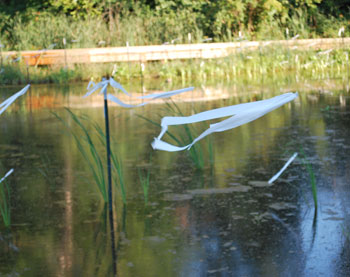
He noted that stakes with white flags had been placed in the West Park detention pond in an attempt to “politely dissuade” water fowl from eating the plants there. He acknowledged that it would be helpful to put up signs explaining the purpose of those flags. He also noted that a memo had been sent to city council earlier this month, providing an update on West Park construction.
Earlier in the day, Smith said, an event to launch the RiverUp! project had been held at Island Park. [At its July 2011 meeting, PAC had been briefed on the project, which is spearheaded by a conservancy group called the Wolfpack, and involves several other partners, including the Huron River Watershed Council, the National Wildlife Federation, the Michigan League of Conservation Voters, and the Community Foundation for Southeast Michigan.] The event had been well attended, he said, but it was also a chance to reflect on how much the city has done over the past decade or so to improve conditions along the river and provide exposure to the river as a recreational resource. It was good to know that the city has taken a lead on that, he said.
Smith also reported that Matt Warba has been promoted to assistant manager of field operations for the city, taking on broader responsibility for operations outside of the parks. Warba was on hand to give a very brief report, focusing on efforts at Plymouth Park. The city continues to battle stormwater runoff from the railroad embankment in that area along Plymouth Road, he said. Engineering work is underway for a longer-term solution, he said, with construction to start in the fall.
Present: David Barrett, Tim Berla, Doug Chapman, Tim Doyle, Julie Grand, Sam Offen, Gwen Nystuen, John Lawter, councilmember Mike Anglin (ex-officio), councilmember Christopher Taylor (ex-officio). Also Colin Smith, city parks manager.
Absent: Karen Levin
Next meeting: PAC’s meeting on Tuesday, Sept. 20, 2011 begins at 4 p.m. in the city hall second-floor council chambers, 301 E. Huron St., Ann Arbor. [confirm date]
The Chronicle survives in part through regular voluntary subscriptions to support our coverage of public bodies like the Ann Arbor park advisory commission. If you’re already supporting The Chronicle, please encourage your friends, neighbors and coworkers to do the same. Click this link for details: Subscribe to The Chronicle.
Regarding dog parks: I don’t believe that additional dog parks will improve leash law compliance. We have lots of dog walkers in our area and it is my belief that they want to take their dogs to locations near their homes. Our little neighborhood natural area, Sunset-Brooks, has a number of people parking their cars and taking dogs into the park, and I’m pretty sure that it is to be off-leash. Also, we have a problem with people walking their dogs off-leash along our streets and there is no enforcement even for this. (Call 911? Are you kidding?)
I don’t quite understand the reference to WALLY in the Fuller Road Station discussion. WALLY would not intersect with the FRS. I recently reviewed that subject in detail [link].
I believe John Satarino’s comment was to the effect of “The city is proposing lots of other transportation capital fund projects as well, such as WALLY, and may not have enough money for all of them.”
That said, I was having a hard time following his remarks, and may have misunderstood his intent.
Ah! I finally learn what those white flags, fishing lines, and stakes at West Park are for.
I think the City should definitely explore online and in-park dog license sales. Just show up at Slauson on Saturday morning / afternoon — they’ll make a mint!
According to this article, the permit has been approved by the state: [link]
Unfortunately, it looks like the B2B trail won’t be paved until Spring 2012, which means the detour will be there for like 2/3rds of a year.
Here’s a .pdf file of the text portion of the state permit for the Argo work: [link]
There seem to be two glaring omissions from the proposed trail connections. How do I get from North Main Street over to Argo Dam without detouring to either Lake Shore Drive or the Broadway bridge? And if I’m headed outbound on Fuller from downtown, how do I get through the dreaded Maiden Lane intersection?
Regarding the proposed new trails and Fuller, it does seem like it would add to the usefulness (and cost) to connect the sidewalks on the north and south side of Fuller with the trails down below.
However, it could be that it’s steep enough that it wouldn’t be ADA compliant without a lot of extra funds. (I haven’t ever stopped and tried to guess where the paths would lie.)
North Main (north of Depot) is a disaster in many ways. I really wish the city had the funds and the authority to make safe, child-friendly non-motorized connections between the waterfront (somewhere near Argo Dam) and the west side of town.