


Miller Avenue to Be Resurfaced and More

The poor condition of the pavement on Miller Avenue in Ann Arbor is the primary impetus behind the project, which could include many other improvements.
There was grumbling among some residents before the meeting even started: “They’re going to do what they’re going to do, it’s already a done deal.”
But the half-dozen city staffers who met with neighbors at Forsythe Middle School last Wednesday presented a variety of different options for how the resurfacing of Miller Avenue between Maple and Newport roads could be undertaken. Construction on the project could begin as soon as 2010, but far more likely is a 2011 start, according to project manager Nick Hutchinson, who’s a civil engineer with the city.
Some irritations from neighbors did surface in the course of the meeting. But reached by phone after the meeting, Hutchinson said he thought it was a healthy exchange and that the project team had been able to collect a lot of useful information.
Beyond Resurfacing
A point of agreement in the room was the need to address a variety of concerns beyond improving the road’s surface, even though the poor condition of the pavement was the impetus behind the project. To Eli Cooper, the city’s transportation program manager, the project represents an opportunity to implement some aspects of the city’s non-motorized transportation plan: (i) installation of sidewalks where there are currently gaps on the south side of Miller, and (ii) widening of bicycle lanes from 3.5 feet to 5 feet.
To Susan Bryan, a city parks planner, and Jerry Hancock, natural resource and environmental planning coordinator, the project represents an opportunity to manage storm water runoff better and to soften the impact of runoff on Allen’s Creek, both in terms of volume and quality.
And the questionnaire circulated at Wednesday’s meeting reflected those goals. Among other questions, the survey asked residents to rank the following components of an improved road cross-section in order of importance:
- On-street parking
- Creating less paved surface
- Storm water improvements/rain gardens
- Bicycle lanes
- Wider lawn extensions
The availability of on-street parking appeared on the list, because some of the alternatives being considered would reduce the amount of street parking.
But one resident pointed out – after multiple people at the meeting had weighed in expressing their support for a signal light at Miller and Newport – that the list about road cross-section components didn’t offer an opportunity for residents to express their concern about the necessity of hazard controls, which had clearly been common thread across many comments. In response, Hutchinson encouraged residents to write in anything they felt was important.
Traffic Hazards
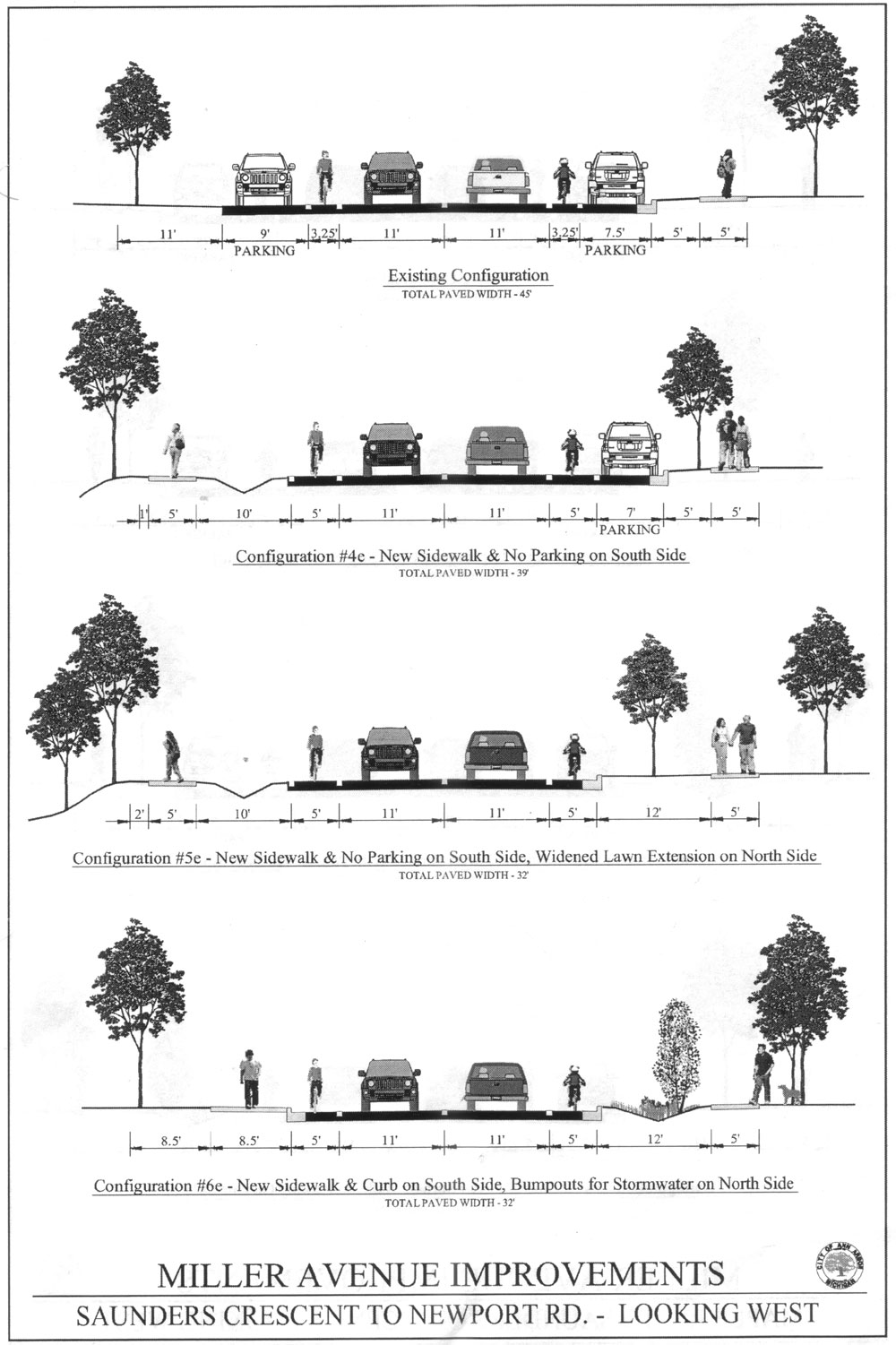
The issue of putting a signal at the intersection at Miller and Newport did arise on multiple occasions. Residents sketched a picture of Miller Avenue during peak morning and afternoon traffic times as an unending stream of vehicles that made it nearly impossible to exit their driveways. The stream included SUVs, school buses, and AATA buses, one woman said: “It’s not just beautiful little cars, it’s heavy traffic!” She was alluding to the sketched-up diagrams that were provided on easels and on handouts, showing the current road cross-section configuration with various alternatives.

Current Miller Avenue road cross section from Newport to Saunders, looking west.
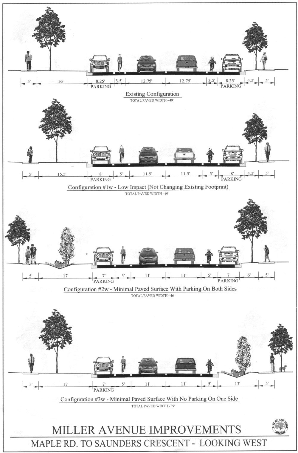
Based on its current cross section, Miller Avenue is divided into two sections: (i) Newport to Saunders, and (ii) Saunders to Maple. Current road cross-section configurations plus sketched examples in .jpg files are availble here: Newport to Saunders, and Saunders to Maple.
In response to the frequent calls for a traffic light at Miller and Newport, Les Sipowski, traffic engineer with the city, explained that the city had undertaken studies in the past and that another one would be done in connection with this project. But he said that past studies of traffic volume did not indicate a signal was justified. Sipowski said that such decisions are based on “warrants,” which is the vocabulary used in the traffic engineering field to describe the thresholds or standards that need to be met in order to install a signal. The Manual on Uniform Traffic Control Devices indicates that eight such warrants are:
- Warrant 1, Eight-Hour Vehicular Volume
- Warrant 2, Four-Hour Vehicular Volume
- Warrant 3, Peak Hour
- Warrant 4, Pedestrian Volume
- Warrant 5, School Crossing
- Warrant 6, Coordinated Signal System
- Warrant 7, Crash Experience
- Warrant 8, Roadway Network
There’s a hump in the road at the intersection that somewhat limits sight distance, but Sipowski said that it still met the guidelines for the indicated speed limit of 35 miles an hour. However, he said that if the construction work gave the city an opportunity to flatten the hump to improve sight distance, then they would do that.

Headed east on Miller. Car in the distance headed left to right is emerging from Newport. Note bus stop at the right. Bike lane is currently 3.5 feet wide. Standard would be 5 feet.
At a couple of different points, residents said flatly, “I don’t care what your study said, we need a signal there!” One resident explained that the number of vehicles measured as going through the intersection might not reflect the fact that people use Pinetree as a cut-through around it – even school buses, she said, though they’re not supposed to.
Sipowski assured residents that as far as a traffic signal went, “It’s not that I’m opposed to this, it’s what I do for a living!”
One resident, a dedicated cyclist, suggested that focus needed to be put on reducing the amount of traffic on Miller – looking at the problem holistically. He suggested that much of the peak-hour traffic was due to parents dropping their kids off at Forsythe, or at the Mack Open School (at 7th and Miller). Ways of reducing that kind of traffic should be looked at, he said. After years of cycling, he said, he did not know how much longer he could continue to put his life at risk to ride along that corridor.
Sidewalks and Funding
Another major resident concern was that the stretch along Miller is included in this season’s city sidewalk repair program – property owners are required to maintain and repair the sidewalks in front of their homes. The concern is that residents might be required spend money on replacing sidewalk slabs this year, only to have the sidewalk torn up and reconstructed in a year or two. Hutchinson said that he was coordinating with the director of the city’s sidewalk program, Brad Kluczynsk. However, he alerted residents to the fact that they would probably see the painted silver circles appear, indicating a needed repair, and would receive letters. He said they could call him for clarification. Said one resident, “You’re going to get a lot of calls!”
For sections on the south side of Miller where there are currently no sidewalks, Hutchinson said that one typical means of financing construction was through a special assessment – owners with property fronting the sidewalk pay. However, he said it was hoped that would not be necessary, depending on how the funding for the whole project came together.
It will be paid for out of a combination of funds: the 2006 street reconstruction millage; water and sanitary sewer funds, and state revolving funds for storm water improvements. This last item is the same funding mechanism being used to finance other projects affecting the Allen’s Creek drainage area, including one on the property of Pioneer High School. The revolving fund is a loan that would be administered through the water resources commissioner’s office (formerly known as the drain commissioner).

Rain garden on Miller Avenue. The garden is the half-moon-shaped depression a the the left of the photo.
Storm Water and Rain Gardens
Some of the project components that might be funded with the loan administered through the water resources commissioner include the idea of reducing the width of paved surface, and using the lawn extension area for a bio-swale – essentially an elongated rain garden. At the Wednesday meeting, it was Susan Bryan, landscape architect with the city, who presented the possibility of using rain gardens as a way of letting some of the water from the road soak in to the ground, instead of trying to lead all of it to directly to storm drains using a gutter system.
The day after the meeting, The Chronicle took a pass through the corridor of the project looking for photo opps to illustrate various aspects of the project. The front of Jeremy Sobczak’s house brought together a couple of different aspects. For one thing, Sobczak’s house is one place where the sidewalk ends – and if the non-motorized plan is implemented, that would change. For another, Sobczak has already installed a rain garden in his front yard, with the assistance of a program administered by the county’s water resources commissioner.
Sobczak is graduating this spring from the University of Michigan with a degree in sustainable landscape design. He took the time to show The Chronicle the hoop house he’d built behind his house, where he has greens already emerging from the planter boxes inside the structure, which is built from electrical conduit draped with double-layered plastic – all supplies acquired from Stadium Hardware, Sobczak said.
Next Steps
Hutchinson said that there were a couple of slots that needed to be filled yet on the design advisory committee by residents who live along he corridor. [If you're interested, contact Hutchinson at nhutchinson AT a2gov.org] The DAC will meet in mid-April, and from mid-April to mid-May, city staff will work on conceptual drawings. In late May there’ll be another DAC meeting, and sometime in June there’ll be a second public meeting. Construction is expected to start in winter/spring of 2011.

Nick Hutchinson, project manager for the Miller Avenue resurfacing.

Les Sipowski, city of Ann Arbor traffic engineer.

Susan Bryan introduces the concept of rain gardens as a component of the project.

Miller Avenue westbound.

Jeremy Sobczak inside his hoop house where he grows food year round.
Things that weren’t addressed here:
1. Cars frequently cross into the bike lanes to swerve around cars that are turning. This illegal activity (it is illegal to cross the solid white bike line for the bike lane) has little to no police actions against it.
2. Buses block bike lanes when picking up and dropping off.
3. Parking on Miller in the winter extends into the bike lanes.
4. What is Ann Arbor doing to reduce traffic? Why are so many parents driving their kids to school?
5. What patching will happen in the next year? The road is bordering on undriveable.
I would echo the comments above. Miller is main traffic conduit in and out of downtown, and it’s too narrow for safe cycling.
I would just strongly support installing a traffic light at the corner of Newport and Miller. One reason that parents may drive their kids to Forsythe is that there is no safe way for children to walk or bike from the neighborhood south of Miller to Forsythe. So installing a traffic light could both slow traffic down and reduce it overall — not to mention improve the health of our middle schoolers.
Re: 1.4 “So many” parents drive their kids to school, including me, because having a child attempt to cross Newport Road in the morning is insanely dangerous! Drivers coming off Newport onto Miller never, ever look for children (or adults, or bikes) walking to school — they are only interested in getting onto Miller Road as quickly as possible in the traffic chaos. The only safe way to get through that intersection in the morning is to ALSO be in a car! My children could easily walk the mile to school, the one and only reason they don’t, is because no one get across Newport Rd safely between 7 and 8 AM.
Secondly, many parents drive to Open(Mack) from the far reaches of the city…Open is a magnet program that enrolls students from the entire town (we’re talking all the way to the edges of Saline, Ypsilanti, Dexter). Due to cost-cutting, the school district does not use enough buses to make those children’s rides a reasonable length. Some of our students at Open would have bus rides in EXCESS of an hour and a half, each way, everyday. Many parents are willing to use the school buses once a day (the afternoon), but not to put their kids on the buses for 3 hours each day! Would you recommend keeping a 6 year old on a school bus for 3 hours a day? It’s hardly a “holisitc” approach. We at Open do not like it either, mind you; it is a constant complaint that the District refuses to fix. Not only are the kids on the buses for too long, they are also forced to transfer buses at the middle schools, without adult supervision or help (imagine your 6 or 7 year old trying to transfer buses at a middle school with hundreds of teenagers runnning around– our little ones can’t even see the buses! Over and over our little ones have been dumped at the middle schools, missed the transfers, and been traumatized by the experiences. It happens every year…and then the parents start driving in. Open families would gladly use the school buses — if the District cared to make the bus runs manageable. But it all comes down to money again…the more parents who drive, the less the District has to spend on transportation. There is no motivation to fix it…and it’s not fair to blame the parents who just want to keep their kids safe and healthy. Money is also why the District will not hire a crossing guard for Newport (frankly, I don’t think the Newport drivers would stop even with a crossing guard!)
About the “Rules” for traffic lights: If there ever was a good exception, Newport-Miller would be it. What makes no sense is that there are plenty of other locations with similar intermittent high volume problems that DO have a traffic light — for example, traffic lights outside factory and business parking lots that allow workers to exit at the end of a shift. There is a similar light just down the street at the exit to Veterans Park. It only turns on when a hundred cars are trying to get out of the baseball fields! So there must be a way around the “rules”…I think the officials use the “rules” in this case to avoid the expense of a new traffic light. I suppose that there are shared funding sources when the “rules” are meant..but not when it is an exceptional problem.
In suggesting a holistic approach to reducing overall traffic volume on Miller — including a reduction in vehicles where a parent drives a child to school — I didn’t take the cyclist at the public forum to be advocating for hour-and-a-half school bus rides, or that parents should just send their kids walking and hope they could dodge the traffic. Apologies if that’s how the article seemed to portray him.
I just took it to mean that non-road-engineering alternatives should be explored — like asking, as CarMom has, what the public schools could do to provide transportation to their magnet schools. Based on the experience described, it sounds like some pessimism is warranted. If there’s some room for optimism, though, I’d say it lies in the fact that AAPS is supposed to be a part of the design advisory committee list of stakeholders. So this could provide an opportunity to try again and get it right.
Otherwise put, I think the call was not so much for parents to just unilaterally stop driving their kids to school, but rather for reasonable alternatives to be provided, so that it wouldn’t be necessary.
I have some vague recollection of an initiative for “walking buses” here in Ann Arbor a few years ago. Here’s a link that mentions Ann Arbor as a place where they’ve been implemented successfully. Any information about which Ann Arbor neighborhoods have active WB programs would be welcome.
Obviously, that doesn’t address kids in Saline getting to Mack Open. And even a “walking bus” would benefit from crosswalks at Newport and Miller that are marked in some way that’s dramatically better than what’s there now.
I am just happy to see this is being addressed. The city seems to be doing a good job of out reach on projects. The Huron Riv. planning dialog has been especially well done.
New, wider bike lanes on Miller will be much appreciated.
Dave, I recall a couple of A2 elementary schools trying to start a “walking bus” and there was some participation at the beginning but it faded quickly.
A lot of road and intersection work is payed for from other sources. The roundabout at Huron Pky. and Nixon is being paid for by the US Govt.
I have no idea but should a roundabout be considered for Miller and Newport. It would slow the traffic down and they seem to work fine for bikes.
Before putting a light at Newport and Miller that operates 24/7 for 365 days a year, why wouldn’t someone propose a crossing guard?
It is senseless to put bike lanes alongside parked cars. Launching over a newly-opened car door at 30 mph will cause serious injury or death. A prudent cyclist who avoids car doors, will be 5′ from the parked cars (into the lane of traffic) and not staying in bike lane). Shame on A^2, the bicycle-friendly city.
And buses?: In Europe they do not violate bike lanes.
Hmm — “But reached by phone after the meeting, Hutchinson said he thought it was a healthy exchange and that the project team had been able to collect a lot of useful information.”
I’m sure he did.
When reached after the meeting, did residents have a similar position? Or were they still feeling agitated?
Re: [9]
I did not attempt to contact any residents after the meeting. I disagree with the implication that this somehow reflects a lack of appropriate balance in reporting.
FWIW, the specific reason I called Hutchinson was not to get his thoughts on the meeting, but rather to establish whether the funding mechanism for the storm water portion of the project was the same one used for the Pioneer High School project.
Based on hearing back from city officials after a number of public engagement sessions on a variety of topics over the last six months, it’s not universal that they feel like it was useful to them — a sentiment that is typically not made for attribution. So when a project manager says that a meeting resulted in useful collection of information, even when some of the commentary was simply: “We don’t care what your study says,” then I think it’s worth including in the report.
Thanks for the response, Dave. The context you’ve added about the call is helpful.
It would be interesting to hear from residents directly once work on the project has been completed or is near completion.
I’m think of setting up some sort of follow-up calendar similar to the (dishearteningly named) Wrong Tomorrow. On that site, predictions are given an expiration date, which encourages long-term responsibility.
What about the rest of Miller – from Newport to Main?!? The section from Seventh to Main is in even worse condition than the section west of Newport – absolutely third world – Kabul’s streets are probably in better shape. It won’t even be drivable, soon, let alone safe for bikes. Most major streets in A2 are either too narrow or too busy for bike traffic anyway. When I had a bike, the only place I ever felt safe was on the sidewalks, or the bike paths along the river. I’ll take my chances with the pedestrians rather than the cement mixers and gravel trains, thank you.
I agree with Rob, you have a chance on a bike until Seventh however after than the road is far too narrow and way too rough.
It’s pretty much a joke that Ann Arbor considers itself a bike town when there are very few true bike routes in the City and even where there are bike paths drives give riders no respect.
I agree with Rob and Kris — and I too have been wondering about the stretch of Miller between Seventh and Main. For bikers, this is extremely rough terrain and completely dangerous. I hate riding my bike on sidewalks but choose to do so on this particular stretch because it is so bumpy, gravelly, and basically, frightening! It is an accident waiting to happen. Actually, many bike accidents have happened already. I keep thinking to myself, is it possible that someone could file a lawsuit against the city for negligence of the road surface? I have no idea if this is a possibility, but it has crossed my mind many times as I have risked my life along Miller.