Stories indexed with the term ‘State Street corridor’

Next Steps Taken on S. State Corridor Plan

Moving ahead on a project that’s been long in the works, Ann Arbor planning commissioners have now recommended that the city council distribute a draft of the South State Street corridor plan to neighboring jurisdictions and other stakeholders, such as the University of Michigan, the Ann Arbor Public Schools, and the Ann Arbor Area Transportation Authority. It’s the next step toward adopting the corridor plan’s recommendations into the city’s master plan. The vote took place at the commission’s Jan. 3 meeting [.pdf of draft South State corridor plan]

The plan includes more than 40 overall recommendations for the corridor, which stretches about 2 miles between Stimson Street at the north end down to Ellsworth in the south. Recommendations are organized … [Full Story]

Two Residential Projects Get Go-Ahead

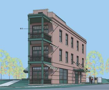
Ann Arbor planning commission meeting (Dec. 18, 2012): Winning praise for its design, the site plan for a proposed three-story “flatiron-style” building at 544 Detroit received a recommendation of approval from planning commissioners at their most recent meeting.

544 Detroit, Rueter Associates Architects, Ann Arbor planning commission, The Ann Arbor Chronicle

A rendering that shows the proposed design for 544 Detroit St., at the corner of Detroit and North Division.

The project is located at the triangle tip of Detroit and North Division, just southwest east of the Broadway bridge – the site of a long-abandoned gas station. The new building would include offices on the first floor and residences on the upper two floors.

It was one of two residential projects that will now move to the Ann Arbor city council for consideration. The other one – Blue Heron Pond – is a townhome development located at the northwest corner of West Liberty and South Maple. A previous project at that location had languished under a different owner after one building was constructed in 2006. The new project includes nine buildings with a mix of two- and three-bedroom rental units.

In other action, rezoning requests for two other projects did not get recommendations for approval. A rezoning request and area plan waiver for 2271 S. State St. – which would allow for auto sales on the site, where Pilar’s Tamales restaurant had been located – was postponed. Planning commissioners wanted to hold off until a South State Street corridor study is completed. That’s expected to happen by the spring of 2013.

And receiving a technical denial was a rezoning request for 490 Huron Parkway from R3 (townhouse district) to R1B (single-family dwelling). Of the six commissioners at the Dec. 18 meeting, only five supported the request. It needed six votes for a recommendation of approval. Bonnie Bona voted against it, saying she supported more dense development in that area, which is located near Huron High School along a bus line. No construction is proposed at this point.

Commissioners also approved the city’s proposed capital improvements plan (CIP). The plan covers the fiscal years 2014-2019, and includes a list of major capital projects, both those that are funded and those for which funding hasn’t yet been identified. [.pdf of CIP for FY 2014-2019] [Full Story]

Rezoning for S. State Site Postponed

A rezoning request and area plan waiver for 2271 S. State St. – which would allow for auto sales on the site – was postponed by the Ann Arbor planning commission at its Dec. 18, 2012 meeting. The city’s planning staff had recommended denial of the requests, noting that the changes did not align with uses in the city’s master plan for that area.

The 2.24-acre site is located on the east side of South State, across the street from a University of Michigan tennis facility. Most recently, Pilar’s Tamales restaurant was located there, though that building is now vacant. The owner, Capital Investment Co., requested rezoning from M1 (limited industrial) to M1A (limited light industrial) so that an auto dealership … [Full Story]

Ideas Floated for South State Corridor

An informal session with University of Michigan urban planning students gave Ann Arbor planning commissioners more ideas for possible changes to the South State Street corridor.

Danielle Thoe, Ann Arbor planning commission, The Ann Arbor Chronicle, South State Street corridor, University of Michigan Taubman College of Architecture & Urban Planning

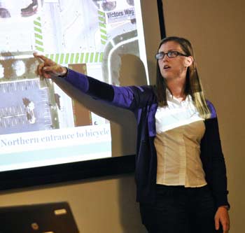
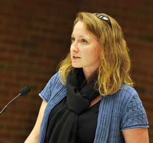
Danielle Thoe, a University of Michigan graduate student in urban planning, explains a concept for creating a boulevard for pedestrians and bicyclists to navigate better the I-94 overpass along South State Street. (Photos by the writer.)

The Nov. 27 meeting included a presentation by four graduate students in urban and regional planning. They had analyzed the corridor between Ellsworth and Stimson, which the city has also been studying. The presentation came in the context of a draft report currently under review by planning commissioners, with more than 40 recommendations to improve the corridor. [.pdf of draft report]

The students approached their work by identifying changes that could have an immediate impact on the corridor, while also looking at more visionary, long-term goals. Shorter-term suggestions included replacing and widening sidewalks, and adding new sidewalks in sections where there are none.

A more ambitious idea is to transform the broad center turn lanes on the I-94 overpass into a protected bicycle/pedestrian median. Currently, navigating the freeway interchange on foot or by bike is daunting. The approach could serve multiple purposes. If bioswales and landscaping were in place along the outer edges, it would help with stormwater management and provide a physical barrier between vehicles and pedestrians/cyclists. The greenery would also have visual impact for people exiting the freeway, indicating that you’re entering a city that values the environment and alternative transportation, according to the students.

Creating a sense of identity along the corridor was a common theme, with an additional focus on safety issues, stormwater management, and functionality/aesthetics.

The meeting was attended by four of the eight current planning commissioners, as well as planning manager Wendy Rampson. The commission is expected to make a recommendation on the city’s draft corridor plan at either its Dec. 18 or Jan. 3 meeting. The Ann Arbor city council would need to approve the plan before any action is taken toward implementing its recommendations. [Full Story]

Sustainability Goals Shape Corridor Study

Ann Arbor planning commission meeting (Sept. 18, 2012): Two projects converged at the most recent planning commission meeting: A draft report of a South State Street corridor study, and next steps toward incorporating the city’s new sustainability goals into its master plan.

Ann Arbor planning commission work session

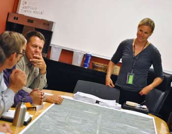
The Sept. 18, 2012  Ann Arbor planning commission work session focused on South State Street – an aerial map of the corridor is spread out on the table. To the right is Kristin Baja, who provided staff support for the project. She’ll be leaving the city to take a job in Baltimore, and was praised by commissioners for her work. (Photos by the writer.)

Eric Mahler recalled that both projects had been highlighted at a planning commission retreat two years ago, and that in some ways their completion marked a new era in city planning. The corridor study is the first project that incorporates the sustainability goals. The study’s recommendations are organized into the four main sustainability categories: resource management; land use and access; climate and energy; and community.

The recommendations themselves cover a wide spectrum of issues, from traffic and walkability to public art and zoning. [.pdf of draft report] Planning commissioners spent nearly two hours reviewing the recommendations in a working session immediately following their regular Sept. 18 meeting. They’ll likely address the project again before it’s forwarded to city council.

Also during the Sept. 18 meeting, planning manager Wendy Rampson reviewed highlights from an annual report of planning activities for the fiscal year 2012, which ended June 30, 2012. The report reflected an increase in development activity within the city. As one example, there were 28 site plans submitted during the year, up from 13 in FY 2011.

Several University of Michigan students attended the commission’s regular meeting on Sept. 18. Responding to a query from Tony Derezinski, they reported that they are graduate students in urban planning, taking a class from professor Dick Norton. Coming to this meeting had been part of a class requirement. [Norton had also been a speaker on some of the panel discussions related to the city's sustainability efforts.] [Full Story]

South State St. Corridor Report Drafted

A draft report of the South State Street corridor plan will be considered at the Sept. 18, 2012 meeting of the Ann Arbor planning commission. [.pdf of draft report] The plan includes more than 40 overall recommendations for improving the corridor, which stretches about 2 miles between Stimson Street at the north end down to Ellsworth in the south.

Recommendations are organized into categories of the city’s recently adopted sustainability framework: Land use and access, community, climate and energy, and resource management. Among the recommendations are: (1) Evaluate use of vacant parcels for alternative energy generation; (2) Evaluate integrating public art along the corridor; (3) Evaluate use of open land for community gardens; (4) Assess and improve high crash areas along the corridor; … [Full Story]

South State Corridor Gets Closer Look

As one of Ann Arbor’s primary north-south corridors, South State Street is being studied with an eye toward improving what some see as a congested, unwelcoming gateway to the city. City planning staff are seeking input and developing recommendations for changes along that 2.5-mile stretch, from Stimson at the north end – where The Produce Station is located – all the way south to Ellsworth.

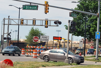
The intersection of South State and Stimson, looking north

The intersection of South State and Stimson, looking north. A study of the South State corridor runs south from Stimson to Ellsworth. (Photos by the writer.)

A diverse range of land uses can be found between those two points, including small commercial enterprises, a large apartment complex, University of Michigan sports facilities, an auto dealership, high-rise office buildings, Briarwood Mall, the snarled I-94 exchange, sprawling research and industrial parks, and the soon-to-open Costco at the southern end, in Pittsfield Township.

The city held a forum recently to update the public about plans for improving South State and to seek input for possible changes. And the Ann Arbor planning commission’s retreat last week focused on the corridor, and included a van tour of the area.

This report covers both of those meetings.

Observations made by planning commissioners about the South State Street corridor at their retreat included: a lack of cohesion; a negative environment for pedestrians and bicyclists; and a sense that the corridor doesn’t reflect the character of Ann Arbor. Several commissioners noted that the stretch is just plain ugly – not an area that evokes the street as a major gateway into Ann Arbor. Suggestions ranged from improved landscaping and wayfinding signs to updating the city’s master plan, reflecting land use goals more in line with the city’s current priorities and sustainability efforts.

This isn’t the only corridor that’s getting attention – efforts to take a strategic look at North Main and Washtenaw Avenue are also underway.

For the South State study, the planning staff expects to develop draft recommendations by the end of this year, with additional public meetings, review by the planning commission, and consideration by the city council. If approved by the council, city staff would begin implementing recommendations. [Full Story]

Ann Arbor Council: Land, Water, Buildings

Ann Arbor city council meeting (Feb. 21, 2012): Land use was one common theme that trickled through the city council’s relatively short meeting.

Amtrak Station

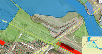
The Ann Arbor city council gave initial approval to new Federal Emergency Management Agency (FEMA) flood maps at its Feb. 21 meeting. The council briefly touched on the topic of the current location of the Amtrak train station, which is in the floodplain (green area). The dark red is a building (Gandy Dancer) that was previously not analyzed as within the floodplain, but now is analyzed as such – similarly for parcels colored bright red. (Image links to higher resolution file with legend.)

The council denied a rezoning request from the owners of Biercamp Artisan Sausage and Jerky, located on South State Street near the Produce Station, that would have allowed them to use the property for a retail operation larger than what currently exists. But the council did give initial approval to a rezoning request from the Society of Les Voyageurs that will allow the group to make an addition to their house, which is located near the Argo Dam.

At the other end of the spectrum from development, the council also took action that will allow the city to move quickly to demolish buildings that are derelict, posing a safety risk to the community. The council authorized the allocation of $250,000 from the general fund to pay upfront costs for the demolition of such structures. The city expects to be able to replenish the money out of a lawsuit settlement it won previously against the owner of the former Michigan Inn. The city will also eventually be able to recover its costs from property owners whose buildings require demolition.

Also related to possible future construction on land throughout the city, as well as the insurance for existing buildings, was the council’s initial approval of new federal flood maps. The most recent maps date from 1992. The new maps being considered for approval by the city were created out of a process begun by the Federal Emergency Management Agency (FEMA). Throughout the city, 452 structures are no longer analyzed as lying within a floodplain, while 88 buildings are newly analyzed as in a floodplain, according to the new maps.

Floods are one of the natural disasters that the city’s new emergency management director, Rick Norman, will be responsible for preparing the city to handle. The council formally authorized Norman’s appointment at their meeting.

In resolutions that required expenditures of funds, the council authorized additional outside accounting and legal expenses, as well as the painting and repair of equipment at the city’s water treatment plant.

In other business, the council passed a resolution in support of a clean air campaign, and authorized the closing of city streets for eight different upcoming events.

Two significant appointments were discussed at the meeting. The first was a mayoral nomination on which the council will be asked to take action at its next meeting – appointing Sue Gott, planner for the University of Michigan, to the board of the Ann Arbor Transportation Authority. The other was an appointment that has already been made by Gov. Rick Snyder – Joe Burke as judge to the 15th District Court. Burke was on hand to be introduced to the council. [Full Story]

Biercamp Parcel Annexation OK’d

At its Oct. 17, 2011 meeting, the Ann Arbor city council approved the annexation 1643 and 1645 S. State Street into the city of Ann Arbor from Ann Arbor Township. A new business, Biercamp Artisan Sausage and Jerky, is located on one of the parcels.

Now that the annexation has been approved, action by the city council on a rezoning request will be scheduled. The owners of Biercamp would like for the city to approve the parcel for C3 (fringe commercial district) zoning. It would allow the business to sell a greater variety of products beyond those that it produces on the premises.

The planning commission voted unanimously to deny C3 zoning for the parcels at its Sept. 8, 2011 meeting. The rezoning request will be the second one considered recently in the general area of State Street and Stimson. On Oct. 3, 2011 the council rejected a request to rezone the parcel where Treecity Health Collective is located – from O (office) to C1 (local business).

The two rezoning requests have prompted discussion by the planning commission and the city council about the need for a study of the South State Street corridor, so that the parcels in question can be considered in a larger context. At an Oct. 11 working session, the planning commission was updated on city planning staff’s in-house effort to conduct a study of the State Street corridor. Previously, the intent was to hire a consultant to do that work.

This brief was filed from the city council’s chambers on the second floor of city hall, located at 301 E. Huron. A more detailed report will follow: [link] [Full Story]

South State Corridor Study Gets Started

At their Oct. 11, 2011 working session, Ann Arbor planning commissioners were briefed on city staff’s efforts to conduct a study of the South State Street corridor, a 2.15-mile section from Ellsworth to Stimson. The corridor is the city’s main gateway from the south. The stretch includes an I-94 interchange, entrances to Briarwood Mall, and other retail, commercial and office complexes. Although there is one large apartment complex along the corridor, it is not a densely residential area.

A previous proposal called for an outside consultant to conduct the study, and about $150,000 had been set aside for that purpose. However, some city councilmembers were reluctant to make the expenditure, and the project was put on hold until now.

Rather than use a … [Full Story]

Rezoning for Biercamp Parcel Voted Down

At its Sept. 8, 2011 meeting, the Ann Arbor planning commission voted unanimously against recommending a rezoning request for the property at 1643 and 1645 S. State St., south of Stimson and next to the Produce Station. The parcels currently house a new business – Biercamp Artisan Sausage and Jerky – as well as an auto repair shop and furniture manufacturer. The recommendation against approval will be forwarded to city council for final action.

Biercamp owners Walt Hansen and Hannah Cheadle want to rezone the property to C3 (fringe commercial district), which would allow their business to sell a wider variety of merchandise, including products not made on site.

The commission first considered this request at its Aug. 16, 2011 meeting, along with a … [Full Story]

Medical Marijuana Rezoning Request Denied

Ann Arbor planning commission meeting (Aug. 16, 2011): Two zoning-related requests on South State Street received mixed responses from planning commissioners, amid calls for a formal study of that corridor.
Treecity Health Collective

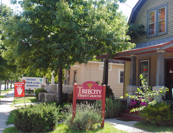
Treecity Health Collective, a medical marijuana dispensary on South State Street. (Photos by the writer.)

One request was the first tied to the city council’s recent approval of zoning regulations for medical marijuana dispensaries. The operator of Treecity Health Collective, a dispensary at 1712 S. State, asked that the location be rezoned from O (office) to C1 (local business). In June 2011, the council approved amendments to the city’s zoning ordinances that prevent medical marijuana dispensaries from operating in office zoning districts. Rather than relocate the dispensary, the operator was asking for the zoning change. The property is located on the west side of State, south of Stimson.

While expressing sympathy for the operator, commissioners recommended denying the rezoning request, noting that the master plan calls for an office district in that area. It will now be forwarded to the city council for final action.

The commission considered a separate request for nearby parcels on the opposite side of South State, where the new Biercamp Artisan Sausage and Jerky opened about a month ago. The property – 1643 and 1645 S. State St., south of the Produce Station – is in Ann Arbor Township, and requires both annexation and zoning. The commission recommended approval of annexing the land, but postponed a decision on zoning. Biercamp owners are hoping for commercial zoning, which would allow them to expand the retail component of their business. The city’s master plan currently calls for light industrial zoning in that section.

In discussions for both Treecity and Biercamp requests, some commissioners pointed to the need for a comprehensive study of the South State Street corridor. Such a study has been planned, but earlier this year the city council voted against funding a consultant to conduct the work.

In other action, commissioners recommended annexing several Scio Township parcels that are located in a recently expanded well prohibition zone related to the Pall/Gelman Sciences 1,4 dioxane underground plume. Pall is paying for the hook-ups to city water and sewer, according to city planning staff.

Commissioners also recommended approval of a site plan at 3590 Washtenaw Ave., at the southwest corner of Washtenaw Avenue and Yost Boulevard. The plan calls for building a 9,500-square-foot, single-story addition to the existing 15,769-square-foot retail building that currently houses the Dollar Tree. It’s in the spot where Frank’s Nursery formerly operated, along the same stretch that’s part of the Reimagining Washtenaw Avenue project.

Wendy Rampson, the city’s planning manager, gave several updates to the commission. Among them, she noted that four projects previously approved by the city council are now asking for two-year extensions on their site plans: (1) The Gallery planned unit development (PUD) on North Main, at the site of the former Greek Orthodox church; (2) the 42 North residential development at Maple and Pauline; (3) the Forest Cove office building on Miller; and (4) the Mallets View office building on Eisenhower. Those requests are being reviewed by city planning staff.

During his communications from city council, Tony Derezinski, who also represents Ward 2 on council, mentioned that a final meeting for the R4C/R2A advisory committee is tentatively set for Sept. 21. He noted that the 21st is also Saint Matthew’s Feast Day, which he quipped might help the group finish up the project.

One member of that advisory committee is former planning commissioner Jean Carlberg, who received a resolution of appreciation from the commission at the beginning of Tuesday’s meeting. Her term ended June 30 – she served on the commission for 16 years. [Full Story]

Planning Group Gets Stormwater Tutorial

Ann Arbor planning commission meeting (May 3, 2011): Tuesday’s meeting featured a presentation on stormwater management by the city’s new water quality manager, Jennifer Lawson.

Jennifer Lawson

Jennifer Lawson, Ann Arbor's new water quality manager, gave a presentation to planning commissioners about the city's stormwater management issues. (Photos by the writer.)

Lawson described the city’s efforts to reduce or eliminate pollutants from entering the Huron River because of stormwater runoff, and fielded a range of questions from commissioners. Her presentation was likely the only time that the term “poo water” and a quote by the Scottish philosopher Thomas Carlyle have occurred during the same public meeting.

Also during Tuesday’s meeting, commissioners approved minor revisions to the city’s master plan, as part of a process that occurs each May. No one spoke during a public hearing on the revisions.

Wendy Rampson, the city’s planning manager, told commissioners that efforts to seek a consultant for a South State Street corridor study have been put on hold, following concerns raised by some city councilmembers over the project’s cost.

In other business, a public hearing was announced for the commission’s May 17 meeting regarding a request by Summers-Knoll School for a special exception use. If granted, the special exception would allow an office building at 2203 Platt Road to be converted into a private school. [Full Story]

State Street Corridor Study Planned

Ann Arbor planning commission working session (April 12, 2011): Moving ahead on a project they’ve discussed for more than a year, planning commissioners gave feedback on a draft request for proposals (RFP) for a South State Street corridor study.

state street corridor

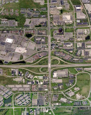
State Street runs north-south. Ellsworth, which runs east-west, is at the bottom of the frame. The large paved area northwest of the I-94/State Street interchange is Briarwood Mall. The proposed area of study extends farther north to Stimson. (Image links to Bing Map.)

The RFP, which will likely be issued next week, will solicit a consultant to develop a comprehensive plan for the 2.15-mile section between Stimson Street to the north – near a railroad crossing and the Produce Station – and Ellsworth to the south.

The corridor is the city’s main gateway from the south – the stretch includes an I-94 interchange, entrances to Briarwood Mall, and other retail, commercial and office complexes. Although there is one large apartment complex along that road, it is not a densely residential area.

Also at Tuesday’s working session, commissioners and staff discussed plans for an April 26 retreat that will focus on another major corridor: Washtenaw Avenue. [Full Story]

Ann Arbor to Issue RFP for State Street Corridor

At their April 12, 2011 working session, Ann Arbor planning commissioners gave feedback on a draft request for proposals (RFP) for a South State Street corridor study. The RFP, which will likely be issued next week, will solicit a consultant to develop a comprehensive plan for the 2.15-mile section between Stimson Street to the north and Ellsworth to the south. Commissioners have discussed this project previously, including at a retreat held in April 2010. [.pdf file of draft State Street Corridor study RFP]

The RFP calls for the study to include: (1) a data inventory and analysis with information on existing conditions for land use, transportation, natural features and other elements; (2) a market analysis to identify demand and redevelopment potential; (3) identification of goals, issues and opportunities for the corridor; (4) identification of possible scenarios for developing the corridor; (5) selection of a preferred land use scenario; (6) identification of action plans and policies to implement the preferred scenario; and (7) development of a final corridor plan report. The process is expected to take 12 months to complete.

Jill Thacher, the city planner who is leading this project, plans to issue the RFP next week, with a mid-May deadline for submitting proposals and selection of a consultant taking place later that month. The planning commission’s master plan review committee – consisting of Wendy Woods, Diane Giannola, Evan Pratt and Erica Briggs – will help select the consultant. The goal is for work to begin in July 2011. Because the study is expected to cost more than $25,000, it would first require city council approval.

This brief was filed shortly after the commission’s Tuesday evening meeting. A more detailed report will follow: [link] [Full Story]